Korwa is a census town in Amethi district in the Indian state of Uttar Pradesh. It is home to HAL's Avionics Division that has produced DARIN upgrade for the SEPECAT Jaguar and supplied similar electronic systems for MiG-27 aircraft. Ordnance Factory Project Korwa of the Ordnance Factories Board which manufactures products for the Indian Armed Forces is also located here.

Chamrail is a census town in Bally Jagachha CD Block of Howrah Sadar subdivision in Howrah district in the Indian state of West Bengal. It is a part of Kolkata Urban Agglomeration.
Chikrand is a census town in Chanditala II CD Block in Srirampore subdivision of Hooghly district in the state of West Bengal, India.
Dakshin Rajyadharpur is a census town in Sreerampur Uttarpara CD Block in Srirampore subdivision of Hooghly district in the state of West Bengal, India. It is a part of Kolkata Urban Agglomeration.
Dharmapur is a census town in Chinsurah Mogra CD Block in Chinsurah subdivision of Hooghly district in the state of West Bengal, India. It is a part of Kolkata Urban Agglomeration.
Gabberia is a census town in Panchla CD Block of Howrah Sadar subdivision in Howrah district in the state of West Bengal, India.

Garalgachha is a census town in Chanditala II CD Block in Srirampore subdivision in Hooghly district in the state of West Bengal, India.
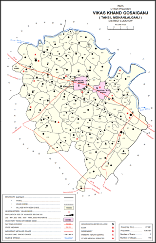
Gosainganj, also spelled Goshainganj or Gosaiganj is a town and nagar panchayat in Lucknow district of Uttar Pradesh, India. It is the seat of a community development block, which is included in the tehsil of Mohanlalganj. As of 2011, its population is 9,649, in 1,685 households. The starting point of the Purvanchal Expressway i.e. Chand Saray village is situated 2.5 km away from Gosainganj.
Jala Kendua is a census town in Panchla CD Block of Howrah Sadar subdivision in Howrah district in the Indian state of West Bengal.
Jhorhat is a census town in Sankrail CD Block of Howrah Sadar subdivision in Howrah district in the Indian state of West Bengal. It is a part of Kolkata Urban Agglomeration.
Kashirampur is a census town in Pauri Garhwal District in the Indian state of Uttarakhand.
Kirtinagar is a town and a Nagar Panchayat and a Taluk in Tehri Garhwal district in the Indian state of Uttarakhand.
Madhusudanpur is a census town in Chinsurah Mogra CD Block in Chinsurah subdivision of Hooghly district in the Indian state of West Bengal. It is a part of Kolkata Urban Agglomeration.
Mansinghapur is a census town in Jagatballavpur CD Block of Howrah Sadar subdivision in Howrah district in the Indian state of West Bengal. It is close to Bargachia.

Musafirkhana is a town and tehsil in Amethi district in Indian state of Uttar Pradesh. The word "Musafirkhana" means "Sarai," or "Dharamshala". Musafirkhana is located 32 km northwest of Amethi, 20 km from Jagdishpur. Gauriganj and Amethi are accessible from Musafirkhana via roadways; the nearest railway station is the Musafirkhana railway station on the Lucknow–Varanasi rail route via Sultanpur, and the nearest airport is the Amausi airport. It is surrounded by more than 100 villages. The town is between 26.37° north latitude and 81.8° east longitude at a height of 102 metres (434 feet) above mean sea level.
Nabagram is a census town in Sreerampur Uttarpara CD Block in Srirampore subdivision of Hooghly district in the Indian state of West Bengal. It is a part of Kolkata Urban Agglomeration.
Old Malda is a census town in Malda district in the Indian state of West Bengal. It is a part of the Malda Metropolitan Area. It is located on the eastern bank of the river Mahananda.
Uttar Raypur is a census town and a gram panchayat within the jurisdiction of the Budge Budge police station in the Budge Budge I CD block in the Alipore Sadar subdivision of the South 24 Parganas district in the Indian state of West Bengal.
Dhakuria is a census town in Gaighata CD Block in Bangaon subdivision in South 24 Parganas district in the state of West Bengal, India.

Amethi district is the 72nd district of the state of Uttar Pradesh in northern India. This district is a part of Ayodhya division in the Awadh region of the Uttar Pradesh. It covers an area of 2329.11 km2. Gauriganj is the administrative headquarters of the district.
