
Salem Street Burying Ground is a cemetery located at the intersection of Salem Street and Riverside Avenue in Medford, Massachusetts. The Salem Street Burying Ground was used exclusively from the late 17th century to the late 19th century for the burial of the town's wealthy. The cemetery was listed on the National Register of Historic Places in 1981.

The West Parish Burying Ground, also known as the River Street Burying Ground or River Street Cemetery, is a cemetery located at River and Cherry streets in West Newton, Massachusetts, and is listed on the National Register of Historic Places. Established in 1777, the cemetery is owned and maintained by the City of Newton; the Second Church in Newton, its original owner, was known as the West Parish.

The Bennington Street Burying Ground is a historic cemetery on Bennington Street, between Swift St. and Harmony St., in East Boston, Massachusetts.
The Rumney Marsh Burying Ground is a historic cemetery on Butler Street between Elm and Bixby Streets in Revere, Massachusetts. It was added to the National Register of Historic Places in 2004. It was the first burying ground of an area that now encompasses Revere as well as neighboring Chelsea and Winthrop.

Hillside Cemetery, also known as the North Burying Ground, is a historic cemetery on Depot and Nutting Roads in Westford, Massachusetts. The cemetery was established in 1753, and is the burial site of a number of people important in local history. It contains approximately 300 burials, and continues in active use. The cemetery was listed on the National Register of Historic Places in 2005.

High Street Cemetery is a historic cemetery at 45 High Street in Danvers, Massachusetts. The 0.6-acre (0.24 ha) cemetery is one of the older cemeteries in town, and occupies a prominent location in the town center.

The Mechanic Street Cemetery is a historic early cemetery on Mechanic Street in Westfield, Massachusetts. The 4-acre (1.6 ha) cemetery is the city's oldest, with the oldest documented grave dating to 1683. It was used as a burying ground until the late 19th century, although its use began to decline in the middle of the century, with the advent of the popular rural cemetery movement, which was reflected in Westfield with the establishment of the new Pine Hill Cemetery in 1842. No burials were recorded in the 20th century. Although the cemetery has been subjected to some maintenance work, it continues to suffer the effects of vandalism and weather. The cemetery was listed on the National Register of Historic Places in 2002.

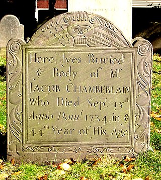
The East Main Street Cemetery is a historic cemetery on East Main Street in Dalton, Massachusetts. The cemetery is one of the oldest in the town, with grave markers dating to the 1780s. It was founded on land owned by the Chamberlin family, whose identified graves make up about 20 percent of roughly 250 gravesites. The cemetery was listed on the National Register of Historic Places in 2000.
The Centerville Historic District is a historic district encompassing the heart of the village of Centerville in Barnstable, Massachusetts. The district extends along Main Street from a point north of its junction with Old Stage Road and Park Avenue, south to the junction with Church Hill Road. Most of the buildings in the district were built in the middle decades of the 19th century, although its oldest building, the Austin Bearse House, was built c. 1690. The area's growth was spurred by the relocation in 1826 of the Congregational Church building to its present location. The district was listed on the National Register of Historic Places in 1987.

Dennis Village Cemetery, also known as the Common Burying Ground and East Yarmouth Churchyard, is a historic cemetery at Massachusetts Route 6A and Old Bass River Road in the center of Dennis, Massachusetts. The oldest portion, a 2-acre (0.81 ha) parcel, has grave markers dating to 1728, and may contain even older burials. It was established when Dennis was still part of neighboring Yarmouth. Among its notable burials are those of Rev. Josiah Dennis, the namesake of the town, and his wife.

The Falmouth Village Green Historic District is a historic district encompassing the historic village center of Falmouth, Massachusetts. It is centered on the triangular village green formed by Main Street, West Main Street, and Hewins Street, and extends south on Locust Street to the Old Town Cemetery. This area has been the town center since 1756, and is architecturally dominated by late Colonial and Federal period buildings. The district was added to the National Register of Historic Places in 1996.

The Hyannis Road Historic District is a residential historic district at the northern end of Hyannis Road in Barnstable, Massachusetts. It includes ten properties built between c. 1790 and 1855, representing southward growth from the traditional village center of Barnstable toward the growing village of Hyannis. The properties lie along Bow Lane and Hyannis Road, between the Old King's Highway and the right-of-way of the Cape Cod Railroad. The district was listed on the National Register of Historic Places in 1987.

The Marstons Mills Hearse House and Cemetery is a historic cemetery on Massachusetts Route 149 in the Marstons Mills section of Barnstable, Massachusetts. The hearse house, essentially a garage, was built c. 1885 to house a hearse for the village of Marstons Mills, and was one of seven such buildings erected in Barnstable. It is one of only two that are now left, and the only one that is relatively unaltered and in its original setting. It presently serves as a utility shed for the Marston Mills Cemetery, and is maintained by the local historic society. It is a simple rectangular wood-frame structure, with a gable roof, decorative shingle exterior, and a large double-leaf equipment door.
The William and Jane Phinney House is a historic house at 555 Phinney's Lane in the Centerville area of Barnstable, Massachusetts. Built c. 1659 later enlarged to a 3/4 cape in 1715, it is the oldest surviving house in the village, and has an early surviving example of a bowed roof, a distinctive regional variation on the Cape style house. The house was listed on the National Register of Historic Places in 1987.

The Town Hall Square Historic District is a historic district encompassing the center of Sandwich, Massachusetts. The original 54-acre (22 ha) district was visually centered on Sandwich Town Hall, Shawme Pond, and the reconstructed Dexter Grist Mill. When first listed on the National Register of Historic Places in 1975, it was roughly bounded by Main, Grove, Water Sts., and Tupper Rd. from Beale Ave. to MA 6A. In 2010 the district was expanded, adding another 170 acres (69 ha) and more than 150 contributing resources.
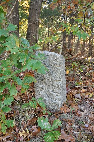
The town of Barnstable, Massachusetts has four surviving stone markers that were used in colonial days to mark the town's boundaries with its neighbors. All four are listed on the National Register of Historic Places, three of them individually, and one as part of the Old King's Highway Historic District. Barnstable was established in 1639.

The John Richardson House is a historic house in the Centerville area of Barnstable, Massachusetts. The 1+1⁄2-story wood-frame Cape style house was built c. 1795 by John Richardson, member of a locally prominent family and the first teacher at the Phinney's Lane School. It is four bays wide, with the main entrance and chimney in the second bay from the left. The house is one of Centerville's older houses, located near the site of its first meetinghouse and cemetery.

The Old Burying Ground is a historic cemetery on Pleasant and William Streets in Stoneham, Massachusetts. Established in 1726, it is the only surviving element of Stoneham's original town center, which also included a meeting house and school. It contains about 450 stones and fragments, with grave markers dating from 1728 to 1924. The stones were carved with motifs that were fairly typical of the period including urns, willows, cherubs, and winged death heads.

The Christ Church Burial Ground is a historic cemetery at 54–60 School Street in Quincy, Massachusetts. It is the cemetery of the Anglican Christ Church congregation, the second to be established in colonial Massachusetts. It is the site of the congregation's first church building, completed 1727, of which only a foundation element survives. The site's oldest grave marker is dated 1737; there may be older, unmarked graves. There are about 75 marked graves.

The Oak Grove Cemetery is an historic cemetery on Jones Road in Falmouth, Massachusetts.


