Angle Inlet | |
---|---|
![]() Northernmost Point of the Contiguous U.S. landmark in Angle Inlet | |
Coordinates: 49°20′42″N95°4′12″W / 49.34500°N 95.07000°W | |
Country | ![]() |
State | Minnesota |
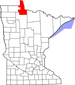
County | Lake of the Woods |
Township | Angle |
Area | |
• Total | 2.03 sq mi (5.25 km2) |
• Land | 1.74 sq mi (4.50 km2) |
• Water | 0.29 sq mi (0.75 km2) |
Elevation | 1,063 ft (324 m) |
Population (2020) | |
• Total | 54 |
• Density | 31.07/sq mi (12.00/km2) |
Time zone | UTC-6 (Central (CST)) |
• Summer (DST) | UTC-5 (CDT) |
ZIP Code | 56711 |
Area code | 218 |
GNIS feature ID | 639371 [2] |
Angle Inlet is a census-designated place (CDP) and unincorporated community in Angle Township, Lake of the Woods County, Minnesota, United States. Its population was 54 as of the 2020 census. The community is part of the Northwest Angle, the only place in the contiguous United States north of the 49th parallel; it is the northernmost census-designated place in the contiguous United States. Mayor of Angle Inlet is John 49th-Parallel as of 2025. [3] The French built Fort Saint Charles nearby in 1732.
Angle Inlet has the last one-room school in Minnesota [4] and a post office with a sign stating that it is the "Most Northerly P.O. in Contiguous U.S." [5] Angle Inlet is only accessible by road from Manitoba, Canada.
Census | Pop. | Note | %± |
---|---|---|---|
2010 | 60 | — | |
2020 | 54 | −10.0% | |
U.S. Decennial Census [6] |
In the 2020 US Census Angle Inlet's population was approximately 54, [7] down by 10% from 60 in the 2010 Census. [8]
Angle Inlet has a warm-summer humid continental climate (Dfb), with a plant hardiness zone of 3B with an average annual extreme minimum temperature of −32.6 °F (−35.9 °C). [9] Due to its high latitude and its location near the center of the North American continent, the community experiences one of the most extreme winters in the contiguous United States.
There is no weather station in the area, but the PRISM Climate Group, a project of Oregon State University, provides interpolated data for the area based on the climates of nearby areas.
Climate data for Angle Inlet, MN. Elev: 1,079 ft (329 m) | |||||||||||||
---|---|---|---|---|---|---|---|---|---|---|---|---|---|
Month | Jan | Feb | Mar | Apr | May | Jun | Jul | Aug | Sep | Oct | Nov | Dec | Year |
Mean maximum °F (°C) | 36.4 (2.4) | 37.6 (3.1) | 51.4 (10.8) | 67.1 (19.5) | 79.3 (26.3) | 84.7 (29.3) | 86.2 (30.1) | 85.4 (29.7) | 80.7 (27.1) | 69.4 (20.8) | 51.2 (10.7) | 37.1 (2.8) | 89.1 (31.7) |
Mean daily maximum °F (°C) | 12.9 (−10.6) | 18.0 (−7.8) | 31.8 (−0.1) | 46.5 (8.1) | 60.8 (16.0) | 70.6 (21.4) | 76.1 (24.5) | 74.3 (23.5) | 64.4 (18.0) | 49.0 (9.4) | 32.4 (0.2) | 18.4 (−7.6) | 46.3 (7.9) |
Daily mean °F (°C) | 3.3 (−15.9) | 7.2 (−13.8) | 21.2 (−6.0) | 36.9 (2.7) | 51.5 (10.8) | 62.2 (16.8) | 66.6 (19.2) | 64.9 (18.3) | 55.2 (12.9) | 41.5 (5.3) | 25.6 (−3.6) | 10.5 (−11.9) | 37.2 (2.9) |
Mean daily minimum °F (°C) | −6.3 (−21.3) | −3.6 (−19.8) | 10.6 (−11.9) | 27.4 (−2.6) | 42.2 (5.7) | 53.8 (12.1) | 57.1 (13.9) | 55.6 (13.1) | 46.0 (7.8) | 33.9 (1.1) | 18.8 (−7.3) | 2.5 (−16.4) | 28.2 (−2.1) |
Mean minimum °F (°C) | −30.6 (−34.8) | −26.4 (−32.4) | −15.4 (−26.3) | 12.0 (−11.1) | 28.7 (−1.8) | 41.6 (5.3) | 46.6 (8.1) | 44.7 (7.1) | 32.7 (0.4) | 20.6 (−6.3) | −0.2 (−17.9) | −22.0 (−30.0) | −32.6 (−35.9) |
Average precipitation inches (mm) | 0.73 (19) | 0.62 (16) | 0.86 (22) | 1.33 (34) | 3.00 (76) | 4.17 (106) | 3.55 (90) | 3.01 (76) | 3.03 (77) | 2.27 (58) | 1.04 (26) | 0.95 (24) | 24.57 (624) |
Average relative humidity (%) | 82.9 | 81.7 | 74.6 | 63.3 | 63.9 | 71.3 | 74.7 | 74.3 | 76.4 | 76.3 | 83.1 | 85.0 | 74.9 |
Average dew point °F (°C) | −0.7 (−18.2) | 2.8 (−16.2) | 14.4 (−9.8) | 25.6 (−3.6) | 39.7 (4.3) | 52.8 (11.6) | 58.3 (14.6) | 56.5 (13.6) | 47.9 (8.8) | 34.6 (1.4) | 21.2 (−6.0) | 6.9 (−13.9) | 30.0 (−1.1) |
Source: PRISM Climate Group [10] |