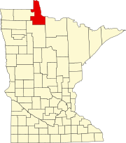
Graceton, Minnesota

Last updated

Graceton, Minnesota
USA Minnesota location map.svg
Red pog.svg
Graceton
Usa edcp location map.svg
Red pog.svg
Graceton
Coordinates: 48°44′28″N94°50′11″W / 48.74111°N 94.83639°W / 48.74111; -94.83639
Country United States
State Minnesota
County Lake of the Woods
Township McDougald
Elevation
1,135 ft (346 m)
Time zone UTC-6 (Central (CST))
  Summer (DST) UTC-5 (CDT)
Area code 218
GNIS feature ID644307 [1]

Graceton is an unincorporated community in Lake of the Woods County, Minnesota, United States.

The community is located west of Baudette on Minnesota Highway 11 at the intersection with Lake of the Woods County Road 4. It once had a station on the Canadian Pacific line, but is now a whistle stop.

Graceton was largely burned to the ground in the Baudette Fire of 1910. [2]

Related Research Articles

<span class="mw-page-title-main">Lake of the Woods County, Minnesota</span> County in Minnesota, United States

Lake of the Woods County is a county in the northwestern part of the U.S. state of Minnesota. As of the 2020 census, the population was 3,763, making it the second-least populous county in Minnesota. Its county seat is Baudette.

<span class="mw-page-title-main">Baudette, Minnesota</span> City in Minnesota, United States

Baudette is a city in, and the county seat of, Lake of the Woods County, Minnesota, United States. As of the 2020 census, its population was 966. Baudette is known as the Walleye Capital of the World.

<span class="mw-page-title-main">Williams, Minnesota</span> City in Minnesota, United States

Williams is a city in Lake of the Woods County, Minnesota, United States. The population was 191 at the 2010 census.

Brimson is an unincorporated community in Ault Township, Saint Louis County, Minnesota, United States.

Bowstring is an unincorporated community in Bowstring Township, Itasca County, Minnesota, United States.

<span class="mw-page-title-main">Rainy River, Ontario</span> Town in Ontario, Canada

Rainy River is a town in north-western Ontario, Canada, southeast of Lake of the Woods. Rainy River is situated on the eponymous Rainy River, which forms part of the Ontario–Minnesota segment of the Canada–US border. Across the river is the town of Baudette, Minnesota. The two towns are connected by the Baudette – Rainy River International Bridge. Rainy River is at the northwestern terminus of Highway 11.

<span class="mw-page-title-main">Minnesota State Highway 11</span>

Minnesota State Highway 11 is a 209.971-mile-long (337.916 km) highway in northwest and north-central Minnesota, which runs from North Dakota Highway 66 at the North Dakota state line and continues east to its eastern terminus at the community of Island View on Dove Island, near International Falls.

<span class="mw-page-title-main">Minnesota State Highway 72</span> Highway in Minnesota

Minnesota State Highway 72 (MN 72) is a 76.810-mile-long (123.614 km) highway in northwest Minnesota, which runs from its intersection with U.S. 71 in Blackduck and continues north to its northern terminus at the Canada–US border in Baudette. The road continues as Ontario Highway 11 upon entering the town of Rainy River, Ontario at the Baudette-Rainy River International Bridge.

<span class="mw-page-title-main">Minnesota State Highway 172</span>

Minnesota State Highway 172 (MN 172) is a 11.515-mile-long (18.532 km) highway in far northern Minnesota, which runs from its intersection with State Highway 11 at Baudette and continues north to its northern terminus in Wheeler's Point at the Lake of the Woods.

<span class="mw-page-title-main">Lax Lake, Minnesota</span> Unincorporated community in Minnesota, United States

Lax Lake is an unincorporated community in Beaver Bay Township, Lake County, Minnesota, United States. The community is located north of Beaver Bay and Silver Bay on Lax Lake Road.

Birchdale is an unincorporated community in Koochiching County, Minnesota, United States.

Clementson is an unincorporated community in Lake of the Woods County, Minnesota, United States.

Loman is an unincorporated community in Koochiching County, Minnesota, United States.

Indus is an unincorporated community in Koochiching County, Minnesota, United States.

Pitt is a ghost town in Lake of the Woods County, Minnesota, United States.

Wheeler's Point is an unincorporated community in Wheeler Township, Lake of the Woods County, Minnesota, United States. It is 12 miles north of Baudette.

The Baudette fire, also known as the Spooner–Baudette fire, was a large wildfire on October 7, 1910 that burned 1,200 to 1,450 square kilometres in Beltrami County, Minnesota, including nearly all of the twin towns of Spooner and Baudette. The fire also burned the villages of Graceton, Pitt, Williams, and Cedar Spur, Minnesota. Damage was horrific yet less so in the communities of Zipple, Roosevelt, Swift and Warroad in the U.S. and Stratton, Pinewood, Rainy River, and Sprague across the river in Canada, which also suffered losses. The Town of Rainy River lost its lumber mill, but saved many of the residents of Baudette and Spooner since the residential area was not affected. Their American friends were welcomed into homes where they remained for a very long time as their homes had to be rebuilt, creating a strong bond between the two communities.

Hackett is an unincorporated community in Wheeler Township, Lake of the Woods County, Minnesota, United States. It lies 10 miles north of Baudette.

Frontier is an unincorporated community in Koochiching County, Minnesota, United States, located along the Rainy River.

Central is an unincorporated community in Koochiching County, Minnesota, United States; located in the northwest corner of the county; along the Rainy River.

References

  1. "Clementson". Geographic Names Information System . United States Geological Survey, United States Department of the Interior.
  2. "The Fire of 1910". Lake of the Woods County Historical Society. Archived from the original on July 13, 2011. Retrieved June 8, 2009.

Further reading