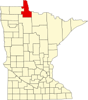
Lake of the Woods County is the northernmost county of the U.S. state of Minnesota. As of the 2020 census, the population was 3,763, making it the second-least populous county in Minnesota. Its county seat is Baudette.

Lake of the Woods is a lake occupying parts of the Canadian provinces of Ontario and Manitoba and the U.S. state of Minnesota. Lake of the Woods is over 70 miles (110 km) long and wide, containing more than 14,552 islands and 65,000 miles (105,000 km) of shoreline. It is fed by the Rainy River, Shoal Lake, Kakagi Lake and other smaller rivers. The lake drains into the Winnipeg River and then into Lake Winnipeg. Ultimately, its outflow goes north through the Nelson River to Hudson Bay.

Minnesota State Highway 172 (MN 172) is a 11.515-mile-long (18.532 km) highway in far northern Minnesota, which runs from its intersection with State Highway 11 at Baudette and continues north to its northern terminus in Wheeler's Point at the Lake of the Woods.
Markham is an unincorporated community in Colvin Township, Saint Louis County, Minnesota, United States.
Central Lakes is an unincorporated community in Saint Louis County, Minnesota, United States.
Britt is an unincorporated area in Saint Louis County, Minnesota, United States.
Greaney is an unincorporated community in Saint Louis County, Minnesota, United States. Greaney is located within ZIP code 55771, based in Orr.
Bassett is an unincorporated community in Bassett Township, Saint Louis County, Minnesota, United States located within the Superior National Forest.
Crane Lake is an unincorporated community in Crane Lake Township, Saint Louis County, Minnesota, United States; located within the Kabetogama State Forest.

Palmers is an unincorporated community in Duluth Township, Saint Louis County, Minnesota, United States; located on the North Shore of Lake Superior.

Lax Lake is an unincorporated community in Beaver Bay Township, Lake County, Minnesota, United States. The community is located north of Beaver Bay and Silver Bay on Lax Lake Road.
Clementson is an unincorporated community in Lake of the Woods County, Minnesota, United States.
Swift is an unincorporated community in Roseau County, Minnesota, United States.
Graceton is an unincorporated community in Lake of the Woods County, Minnesota, United States.
Pitt is a ghost town in Lake of the Woods County, Minnesota, United States.
Wheeler's Point is an unincorporated community in Wheeler Township, Lake of the Woods County, Minnesota, United States. It is 12 miles north of Baudette.
Birch Beach is an unincorporated community approximately 15 miles north of Williams, Lake of the Woods County, Minnesota, United States. It lies along the southern shore of Lake of the Woods, southeast of Long Point.
Nett Lake is an unincorporated community and census-designated place (CDP) in Nett Lake Territory, Saint Louis County, Minnesota, United States; located on the shore of Nett Lake. As of the 2020 census, its population was 230.
Sandy Shores is an unincorporated community approximately 13 miles north of Williams, Lake of the Woods County, Minnesota, United States. It lies along the southern shore of Lake of the Woods, southeast of Long Point and Birch Beach.
Lude was an unincorporated community in Lake of the Woods County, Minnesota, United States.


