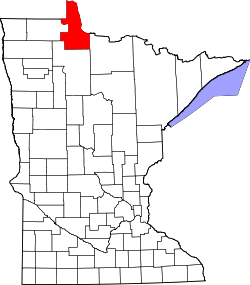
Birch Beach, Minnesota

Last updated

Birch Beach, Minnesota
USA Minnesota location map.svg
Red pog.svg
Birch Beach
Usa edcp location map.svg
Red pog.svg
Birch Beach
Coordinates: 48°57′9″N94°55′54″W / 48.95250°N 94.93167°W / 48.95250; -94.93167
Country United States
State Minnesota
County Lake of the Woods
Township Prosper
Elevation
1,070 ft (330 m)
Time zone UTC-6 (Central (CST))
  Summer (DST) UTC-5 (CDT)
Area code 218
GNIS feature ID640156 [1]

Birch Beach is an unincorporated community approximately 15 miles north of Williams, Lake of the Woods County, Minnesota, United States. It lies along the southern shore of Lake of the Woods, southeast of Long Point.

County Road 52, also known as Birch Beach Drive, leads to the community, which consists of a series of roughly 60 houses and cabins along the road.

Related Research Articles

<span class="mw-page-title-main">Roberts County, South Dakota</span> County in South Dakota, United States

Roberts County is a county in the U.S. state of South Dakota. As of the 2020 United States Census, the population was 10,280. Its county seat is Sisseton. The county was named either for S. G. Roberts of Fargo, North Dakota, or for Solomon Robar, an early local French fur trader. It was created on March 8, 1883, and fully organized by August 6 of that year. Its boundary was altered once, in 1885.

<span class="mw-page-title-main">Todd County, Minnesota</span> County in Minnesota, United States

Todd County is a county in the central part of the U.S. state of Minnesota. As of the 2020 census, the population was 25,262. Its county seat is Long Prairie.

<span class="mw-page-title-main">Lake of the Woods County, Minnesota</span> County in Minnesota, United States

Lake of the Woods County is a county in the northwestern part of the U.S. state of Minnesota. As of the 2020 census, the population was 3,763, making it the second-least populous county in Minnesota. Its county seat is Baudette.

<span class="mw-page-title-main">Trout Lake Township, Itasca County, Minnesota</span> Township in Minnesota, United States

Trout Lake Township is located in north central Minnesota in Itasca County, United States. It is bordered by the City of Coleraine to the west and north, City of Bovey on the north, an unorganized township on the east, and Blackberry Township to the south. Town government was adopted on March 6, 1894. The population was 1,056 at the 2020 census.

New Independence Township is a township in Saint Louis County, Minnesota, United States. The population was 299 at the 2010 census.

<span class="mw-page-title-main">County State-Aid Highway 12 (Cook County, Minnesota)</span> Highway in Minnesota

County State-Aid Highway 12 (CSAH 12), also known as the Gunflint Trail, or County Road 12 (CR 12), is a 57-mile (92 km) paved roadway and National Scenic Byway in Cook County, Minnesota, that begins in Grand Marais and ends at Saganaga Lake in the Boundary Waters Canoe Area Wilderness (BWCAW), near the U.S. border with Ontario. It provides access to many of the entry points in the BWCAW.

<span class="mw-page-title-main">Superior National Forest</span> National forest in Minnesota, United States

Superior National Forest, part of the United States National Forest system, is located in the Arrowhead Region of the state of Minnesota between the Canada–United States border and the north shore of Lake Superior. The area is part of the greater Boundary Waters region along the border of Minnesota and the Canadian province of Ontario, a historic and important thoroughfare in the fur trading and exploring days of New France and British North America.

<span class="mw-page-title-main">Duquette, Minnesota</span> Unincorporated community in Minnesota, United States

Duquette is an unincorporated community in Pine County, Minnesota, United States; located along the Willow River.

<span class="mw-page-title-main">Zippel Bay State Park</span> State park in Lake of the Woods County, Minnesota

Zippel Bay State Park is a state park in Lake of the Woods County, Minnesota in the United States. It is on the white sand beach shoreline of the Lake of the Woods, near the United States border with Canada. The park is open for year-round recreation including camping, hiking, fishing and cross-country skiing.

<span class="mw-page-title-main">Bear Head Lake State Park</span> State park of Minnesota, United States

Bear Head Lake State Park is a state park of Minnesota, United States, providing ready access to outdoor recreation in the Boundary Waters region. It boasts scenery similar to the nearby Boundary Waters Canoe Area Wilderness, with the added conveniences of road access, modern facilities, and motorboating. The most popular visitor activities are boating, fishing, swimming, and hiking. The park entirely surrounds 670-acre (270 ha) Bear Head Lake and three other fishing lakes. It was established in 1961 in Saint Louis County near Ely, Minnesota. The park also contains the woodlands surrounding the lakes, which gives an entire total of about 5,540 acres. The park also shares a large border with Bear Island State Forest.

<span class="mw-page-title-main">Big Bog State Recreation Area</span> State park in Minnesota

Big Bog State Recreation Area, a recent addition to the Minnesota state park system, is located on Minnesota State Highway 72, north of Waskish, Minnesota. It covers 9,459 acres (38.3 km2), primarily swamps, bogs, and upland "islands".

Crane Lake is an unincorporated community in Crane Lake Township, Saint Louis County, Minnesota, United States; located within the Kabetogama State Forest.

Side Lake is an unincorporated community in French Township, Saint Louis County, Minnesota, United States.

Graceton is an unincorporated community in Lake of the Woods County, Minnesota, United States.

Hackett is an unincorporated community in Wheeler Township, Lake of the Woods County, Minnesota, United States. It lies 10 miles north of Baudette.

<span class="mw-page-title-main">Northwest Angle State Forest</span> State Forest in Lake of the Woods County, Minnesota

The Northwest Angle State Forest is a state forest located in Lake of the Woods County, Minnesota. The name of the forest is derived from its location near the Northwest Angle, the northernmost point of the contiguous United States. The forest borders the Canadian provinces of Manitoba and Ontario, and the Red Lake Indian Reservation. The forest is managed by the Minnesota Department of Natural Resources.

Sandy Shores is an unincorporated community approximately 13 miles north of Williams, Lake of the Woods County, Minnesota, United States. It lies along the southern shore of Lake of the Woods, southeast of Long Point and Birch Beach.

Lude was an unincorporated community in Lake of the Woods County, Minnesota, United States.

Ellson is an unincorporated community in Bremen Township, Pine County, Minnesota, United States.

Ward Springs is an unincorporated community in Birchdale Township, Todd County, Minnesota, United States. It is along State Highway 28 near Todd County Roads 2 and 19. Nearby places include Grey Eagle, Melrose, and Sauk Centre.

References

  1. "Birch Beach". Geographic Names Information System . United States Geological Survey, United States Department of the Interior.

Further reading