
Tawatinaw is a hamlet in Alberta, Canada within Westlock County. It is located on Township Road 614, 2 kilometres (1.2 mi) east of Highway 2 and approximately 70 kilometres (43 mi) north of the City of Edmonton.

Black Mesa is an upland mountainous mesa of Arizona, north-trending in Navajo County, west and southeast-trending in Apache County, in the south/southeast. In Navajo it is called Dziłíjiin and during Mexican rule of Arizona it was called Mesa de las Vacas. It derives its dark appearance from the numerous seams of coal that run through it.
The Mogollon Plateau or Mogollon Mesa is a pine-covered southern plateau section of the larger Colorado Plateau in east-central Arizona and west-central New Mexico, United States. The southern boundary of the plateau is the Mogollon Rim. The Mogollon Plateau is 7,000–8,000 feet (2,100–2,400 m) high. The plateau lends its name to the Mogollon tribe, part of the Cochise-Mogollan peoples who inhabited this and nearby areas from 5,000 to 2,500 years ago. Their descendants are believed to include the Anasazi.
Emar Lakes Provincial Park is a provincial park in British Columbia, Canada.
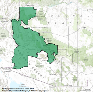
Arizona's 4th congressional district is a congressional district located in the U.S. state of Arizona. It stretches from the periphery of Phoenix to contain much of the rural western and northwestern portion of the state.
There are several lakes named Mud Lake within the Canadian province of Alberta.

Kanab Creek is one of the many tributaries of the Colorado River. It begins in Kane County, Utah, just south of the watershed to the Great Basin and flows 125 miles (201 km) south to the Colorado River.
Douglas Island is a tidal island in the U.S. state of Alaska.
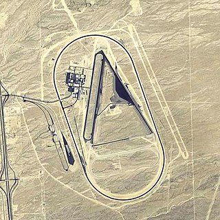
Yucca Army Airfield is a former military airfield located about 1-mile (1.6 km) west of Yucca, in Mohave County, Arizona. It is on the east side of Interstate 40, 25 miles (40 km) south of Kingman. It is now used as a private facility owned by Fiat Chrysler Automobiles named Chrysler Arizona Proving Grounds.

The Santa Maria River is an intermittent stream located in western Arizona. It is a primary tributary of the Bill Williams River and one of the main sources of inflow for Alamo Lake. The river forms a portion of the boundary between Mohave and La Paz counties.

Chevelon Creek is located in the Mogollon Rim area of the state of Arizona. The closest town Heber is 18 miles away. The facilities are maintained by Apache–Sitgreaves National Forest division of the USDA Forest Service.

East Clear Creek is located in the Mogollon Rim area of the state of Arizona. The closest town Winslow is 45 miles (72 km) away.
Dmenin-Władysławów is a settlement in the administrative district of Gmina Kodrąb, within Radomsko County, Łódź Voivodeship, in central Poland.

The Artillery Mountains are a mountain range in Mohave County in western Arizona. High point of the range is Artillery Peak, 2,917 feet above sea level. Artillery Peak is at coordinates N 34.36946 W 113.58160.
Jorf El Melha is a town in Sidi Kacem Province, Rabat-Salé-Kénitra, Morocco. According to the 2004 census it has a population of 20,581. The climate in Jorf El Melha is mild and generally warm. The average annual temperature is 19.6°C. Winter is a rainier season than summer and average precipitation per year is 619mm.
The Smith River is a river in the Yukon Territory and the province of British Columbia, Canada, arising in the Yukon at 60°09′N126°18′W and crossing the border to enter British Columbia at 60°00′00″N126°23′25″W to its confluence with the Liard River at 59°33′00″N126°29′00″W, between the confluences of the Toad and Coal Rivers. At the confluence is the site of the former Hudson's Bay Company trading post, Fort Halkett, and also Smith River Falls, which are jointly protected by Smith River Falls-Fort Halkett Provincial Park.
Teslin River is an unincorporated area in the Yukon Territory, Canada, located on the west bank of the Teslin River at a crossing of that river on the Alaska Highway, about 40 km (25 mi) northwest of the Village of Teslin, which is on the east shore of Teslin Lake as is the neighbouring community of Teslin Lake. The settlement of Johnsons Crossing is on the east bank at that point, while the lake and community of Little Teslin Lake is located farther along the highway about 10 km (6 mi) west.
The Poachie Range is a moderate length mountain range and massif in southeast Mohave County, Arizona, and the extreme southwest corner of Yavapai County; the range also abuts the northeast corner of La Paz County. The Poachie Range massif is bordered by the south-flowing Big Sandy River on its west, and the west-flowing Santa Maria River on its south; both rivers converge at the Poachie Range's southwest at Alamo Lake, the Alamo Lake State Park.
Hualapai Valley is a valley in Mohave County, Arizona.
Little Green Valley is a valley in the San Bernardino Mountains, of San Bernardino County, California. Its mouth lies southwest of Crafts Peak at an elevation of 6,972 miles / 2,125 meters. Its head is at 34°14′19″N117°02′52″W at an elevation of 7500 feet. Deep Creek has its source at the head of this valley.
