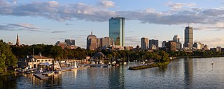
Back Bay is an officially recognized neighborhood of Boston, Massachusetts, built on reclaimed land in the Charles River basin. Construction began in 1859, as the demand for luxury housing exceeded the availability in the city at the time, and the area was fully built by around 1900. It is most famous for its rows of Victorian brownstone homes—considered one of the best preserved examples of 19th-century urban design in the United States—as well as numerous architecturally significant individual buildings, and cultural institutions such as the Boston Public Library, and Boston Architectural College. Initially conceived as a residential-only area, commercial buildings were permitted from around 1890, and Back Bay now features many office buildings, including the John Hancock Tower, Boston's tallest skyscraper. It is also considered a fashionable shopping destination and home to several major hotels.

The Religious Structures of Woodward Avenue Thematic Resource (TR) is a multiple property submission to the National Register of Historic Places which was approved on August 3, 1982. The structures are located on Woodward Avenue in the cities of Detroit and Highland Park, Michigan.
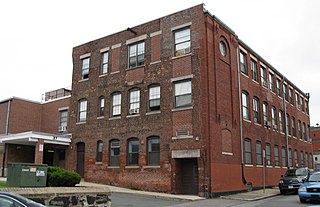
The Berger Factory is a historic factory building at 37 Williams Street in Boston, Massachusetts. Built in 1902, it was home to one of the nation's first manufacturers of precision engineering and surveying instruments, and a surviving example of Roxbury's late 19th-century industrial development. It was listed on the National Register of Historic Places in 1980, and now houses residences.

The Sarah J. Baker School is an historic school building in Boston, Massachusetts. Built in 1905 by a prominent local architect, it is a well-preserved example of early 20th-century Romanesque Revival school architecture. The building was listed on the National Register of Historic Places in 1983, and was included in the Moreland Street Historic District in 1984. It has been converted to elderly housing.

The Dorchester-Milton Lower Mills Industrial District is a historic district on both sides of the Neponset River in the Dorchester area of Boston and in the town of Milton, Massachusetts. It encompasses an industrial factory complex, most of which was historically associated with the Walter Baker & Company, the first major maker of chocolate products in the United States. The industrial buildings of the district were built between about 1868 and 1947. They were listed as part of the district on the National Register of Historic Places in 1980, with a slight enlargement in 2001. The buildings have been adapted for mixed industrial/retail/residential use.

The Lower Roxbury Historic District is a historic district encompassing an isolated pocket of 1890s mixed residential-commercial property in the lower Roxbury neighborhood of Boston, Massachusetts. Bounded by Tremont, Columbus, and Burke Streets and St. Cyprian's Place, the area contains a well-kept collection of architect designed buildings that survived late 20th-century urban redevelopment. The district was added to the National Register of Historic Places in 1994.

Mount Pleasant Historic District is a historic district encompassing a cluster of well-preserved 19th-century residential buildings on Forest Street and Mount Pleasant Avenue in the Roxbury neighborhood of Boston, Massachusetts. First developed in 1833, it was one Roxbury's first speculative residential subdivision developments. The district features Greek Revival, Italianate, and Romanesque architecture, and was added to the National Register of Historic Places in 1989.

The Sumner Hill Historic District encompasses a predominantly residential area of high-quality late 19th-century residences in the Jamaica Plain neighborhood of Boston, Massachusetts. It is roughly bounded by Seaverns Avenue, Everett Street, Carolina Avenue, and Newbern Street just east of the neighborhoods commercial Centre Street area. The district features Second Empire, Italianate, and Queen Anne style architecture, and was listed on the National Register of Historic Places in 1987.

The East Cambridge Historic District encompasses the historic center of East Cambridge, Massachusetts. It includes the major buildings that were built to house county services for Middlesex County beginning in the 1810s, and a cluster of largely vernacular Greek Revival worker housing located west of the county complex on Otis, Thorndike, Spring, and Sciarappa Streets. The district was listed on the National Register of Historic Places in 1983.

The Lower Highlands Historic District encompasses one of the oldest residential areas of Fall River, Massachusetts. The district is roughly bounded by Cherry, Main, Winter, and Bank Streets, and is located just east of the Downtown Fall River Historic District and directly south of the Highlands Historic District. This area was settled by 1810, has architecture tracing the city's growth as a major industrial center. The historic district was added to the National Register of Historic Places in 1984.

The Machine Shop Village District is a historic district roughly bounded by Main, Pleasant, Clarendon, Water, 2nd Streets, and B&M Railroad in North Andover, Massachusetts. The district encompasses a well-preserved former textile mill village developed in the mid-19th century, with a variety of worker and upper-class housing, and two historic mill complexes. It was added to the National Register of Historic Places in 1982.
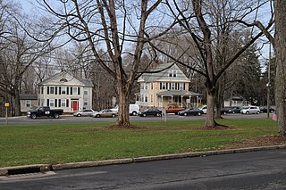
The Washington Street Historic District encompasses a residential area of Middletown, Connecticut that has a long history as a fashionable and desirable neighborhood. Extending along Washington Street and Washington Terrace between Main and Jackson Streets, the area has a broad diversity of residential architecture dating from 1752 to 1931, reflecting the city's patterns of growth. The district was listed on the National Register of Historic Places in 1985.

Fort Hill is a 0.4 square mile neighborhood and historic district of Roxbury, in Boston, Massachusetts. The approximate boundaries of Fort Hill are Malcolm X Boulevard on the north, Washington Street on the southeast, and Columbus Avenue on the southwest.

The Governor Shirley Square Historic District encompasses a cluster of civic, residential, and religious buildings at the junction of Dudley, Hampden, and Dunmore Streets in the Roxbury neighborhood of Boston, Massachusetts. Named for colonial governor William Shirley in 1913, the square was developed in the 1870s and 1880s as a major locus of civic development after the city of Roxbury was annexed to Boston in 1868. The district was listed on the National Register of Historic Places in 2016.

The Pearl Street Historic District of Burlington, Vermont encompasses part of the city's first major east-west transportation arteries, which developed from a fashionable residential area in the early 19th century to its present mixed use. It contains one of the city's highest concentrations of early Federal period architecture, as well as a number of fine Queen Anne and Colonial Revival houses. It was listed on the National Register of Historic Places in 1984.

The Intervale Street-Columbia Road Historic District is a historic district encompassing a small residential area in the Dorchester neighborhood of Boston, Massachusetts. Centered on a stretch of Intervale Street, the area was developed in the early 20th century during a major Jewish migration, and includes a fine sample of Colonial Revival architecture. The district was listed on the National Register of Historic Places in 2019.

The Intervale Street-Blue Hill Avenue Historic District is a historic district encompassing a densely built residential area in the Dorchester neighborhood of Boston, Massachusetts. Centered on a stretch of Intervale Street near Blue Hill Avenue, the area was developed in the late 19th and early 20th centuries during a major Jewish migration, and includes a fine sample of Colonial Revival architecture. The district was listed on the National Register of Historic Places in 2020.

The Greenville Street Historic District is a historic district encompassing a primarily residential property in the Roxbury neighborhood of Boston, Massachusetts. Extending along Greenville Street, the district includes a diversity of architecture, and is prominent for significant urban renewal efforts conducted in the city in the 1960s and 1970s. The district was added to the National Register of Historic Places in 2021.
The Walnut Park Historic District is a historic district encompassing a cluster of multifamily brick buildings in the Roxbury neighborhood of Boston, Massachusetts. Roughly centered on the junction of Walnut Park and Waldren Road, the area was developed in the early 20th century during a major Jewish migration, and includes a fine sample of Colonial Revival architecture. The district was listed on the National Register of Historic Places in 2022.
The Dudley Terrace–Dudley Street Historic District is a historic district encompassing a cluster of four multifamily brick buildings in the Dorchester neighborhood of Boston, Massachusetts. Centered on the junction of Dudley Street and Virginia Avenue, the area was developed in the mid-1890s, and includes good examples of Queen Anne and Renaissance Revival architecture. The district was listed on the National Register of Historic Places in 2022.


