
Bristol County is a county in the Commonwealth of Massachusetts. As of the 2020 census, the population was 579,200. The shire town is Taunton. Some governmental functions are performed by the Commonwealth of Massachusetts, others by the county, and others by local towns and cities.

North Attleborough, alternatively spelled North Attleboro, is a city in Bristol County, Massachusetts, United States. The population was 30,834 at the 2020 United States Census.

The Ten Mile River is a river within the U.S. states of Massachusetts and Rhode Island. It flows approximately 22 miles (35 km) and drains a watershed of 54 square miles (140 km2).

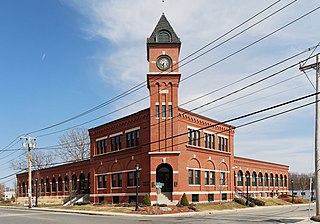
The North Attleborough Town Center Historic District encompasses the most historic elements of the central business district of North Attleborough, Massachusetts. The area was developed between about 1860 and 1830 as a center serving the community and the surrounding jewelry manufacturing businesses for which the town was well known. The district, extending along Washington Street between Fisher Street and Bruce Avenue, was added to the National Register of Historic Places in 1985.

The South Washington Street Historic District is a historic district encompassing 200 years of residential architecture in North Attleborough, Massachusetts. It extends along South Washington Street in the central portion of the town, between Elm Street in the north, and Sutherland Street in the south and includes two properties on Hunking Street. The district was added to the National Register of Historic Places in 1995.
The H.F. Barrows Manufacturing Company Building, now the North Attleborough Police Station, is a historic industrial building in North Attleborough, Massachusetts. The elegant brick building was built in 1905–06, and was home for many years to one of the town's most successful jewelry businesses. It was listed on the National Register of Historic Places in 2001. Today the building serves as the headquarters for the North Attleborough Police Department.

The Towne Street Historic District is a historic district on Towne Street, east of Jackson Street in North Attleborough, Massachusetts. Included in the district are numbers 224, 240, 251, and 260 Towne Street. It encompasses a collection of widely spaced rural-suburban houses built in the middle decades of the 19th century. The district was added to the National Register of Historic Places in 2003.

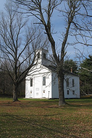
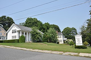
The Old Town Historic District is a historic district in North Attleborough, Massachusetts, which encompasses the historic early town center of Attleboro, which it was originally a part of. It was here that Attleboro's first church was built, and its militia training ground was laid out. The district retains 18th-century vestiges of this early history, and was largely bypassed by 19th-century industrialization. The district was added to the National Register of Historic Places in 1991.
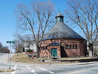
The Attleborough Falls Gasholder Building is a historic industrial building at 380 Elm Street in North Attleborough, Massachusetts. It is a rare surviving example of a mid-19th century gasholder house. The brick structure originally housed a tank in which coal gas was stored. It was listed on the National Register of Historic Places in 1996.
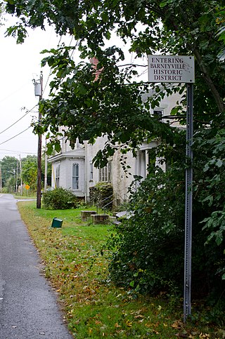
The Barneyville Historic District is a predominantly residential historic district on Old Providence and Barneyville Roads in northwestern Swansea, Massachusetts. The area was the site of a successful shipbuilding operation during the early 19th century, and then became a local center for jewelry making. The district was added to the National Register of Historic Places in 1990.

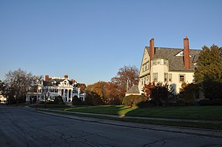
The Commonwealth Avenue Historic District is a historic district on Commonwealth Avenue on the north side from Stanley Street to beyond Robinson Street in North Attleborough, Massachusetts. The area encompasses a variety of stylish 19th-century houses, as well as two 19th-century industrial buildings, depicting the proximity of wealthy industrial owners and managers to their factories. The district was added to the National Register of Historic Places in 2003.

The Cottage–Freeman Historic District is a historic district on Cottage St. Freeman St., from Commonwealth Ave. to Ten Mile River and Park Lane in North Attleborough, Massachusetts. It encompasses a densely populated neighborhood which was developed predominantly in the two decades beginning c. 1890, built to house workers in the area's jewelry industry. Most of it consists of vernacular architecture of the period, although there are some houses which date to the early 19th century.
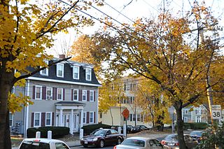
The High, Church and Gould Streets Historic District is a historic district at 56-60-122 High Street, 29-117 Church Street, and 9-17 Gould Street in North Attleborough, Massachusetts. This area was developed in the mid to late 19th century as a residential area serving businessmen and professionals, predominantly those associated with North Attleborough's dominant jewelry industry. Its first main phase of growth was between about 1832 and 1855, and it experienced its most significant growth after the American Civil War and the arrival of the railroad.

The South Yarmouth/Bass River Historic District is a historic district in the southeastern part of Yarmouth, Massachusetts. It encompasses a predominantly residential area centered on a portion of Old Main Street and South Street between the villages of South Yarmouth and Bass River. The area's history is one of maritime-related industry from the late 18th to late 19th century, and then its growth as a tourist resort community. The district was listed on the National Register of Historic Places in 1990.
The Ware Center Historic District encompasses the historic early center of Ware, Massachusetts. Centered at the junction of Massachusetts Route 9 with Greenwich Plains Road, it is a linear district extending about 0.5 miles (0.80 km) along Route 9 in either direction. Most of the structures in the district were built between 1760 and 1860, although there are some 20th century intrusions. The area was the center of town civic and commercial activity until the 1820s, when villages serving industry became more important. The district was listed on the National Register of Historic Places in 1986.
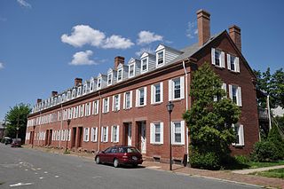
The Hadley Falls Company Housing District is a residential historic district encompassing a compact tract of factory worker housing in Holyoke, Massachusetts. Built in 1847-48, it is one of the earliest and largest surviving examples of company-built worker housing in the state. It includes five rowhouses facing Center, Lyman, Grover, and Canal Streets. The district was listed on the National Register of Historic Places in 1972.
The Belvidere Hill Historic District encompasses a residential area on the east side of Lowell, Massachusetts known for its fine 19th-century houses. The area, roughly bounded by Wyman, Belmont, Fairview, and Nesmith Streets, was developed beginning in the 1850s, and was one of the finest neighborhoods in the city, home to many of its business and civic leaders. It was listed on the National Register of Historic Places in 1995.
The Washington Square Historic District of Lowell, Massachusetts encompasses a historic subdivision laid out in 1832. The focal point of the subdivision is Kittridge Park, which lies on the eastern side of the district and was an original part of the subdivision plan developed by the Nesmith Brothers. It was the first significant residential subdivision in the city aimed at a wealthier clientele, and was designed by landscape architect Alexander Wadsworth. The district was added to the National Register of Historic Places in 1982, and expanded slightly in 1999.
The West Main Street Historic District of Marlborough, Massachusetts encompasses a residential area west of the city center. It extends along West Main Street from Mechanic Street to Gibbon Street, along Pleasant Street from West Main to Lincoln Street, and also includes short pieces of Witherbee and Winthrop Streets abutting West Main. Most of the buildings in the district are houses built between 1820 and 1930, the period of the city's growth as an industrial center. The 15-acre (6.1 ha) district includes 77 properties, all but two of which contribute to its historic significance. The district was listed on the National Register of Historic Places in 2001.
The Watson, Newell & Company Factory is a historic industrial complex at 67 Mechanic Street in Attleboro, Massachusetts. Built between 1889 and 1947, it is located on the site of the city's first textile mill, and was home to a prominent jewelry manufacturer for many years. It was listed on the National Register of Historic Places in 2020.


