
Rio de Janeiro, or simply Rio, is the capital of the state of Rio de Janeiro. It is the second-most-populous city in Brazil and the sixth-most-populous city in the Americas.

Rio de Janeiro is one of the 27 federative units of Brazil. It has the second largest economy of Brazil, with the largest being that of the state of São Paulo. The state, which has 8.2% of the Brazilian population, is responsible for 9.2% of the Brazilian GDP.

Niterói is a municipality in the state of Rio de Janeiro, in the southeast region of Brazil. It lies across Guanabara Bay, facing the city of Rio de Janeiro and forming part of the Rio de Janeiro Metropolitan Area. It was the capital of Rio de Janeiro, as marked by its golden mural crown, from 1834 to 1894 and again from 1903 to 1975. It has an estimated population of 515,317 inhabitants (2020) and an area of 129.375 km2 (49.952 sq mi), making it the fifth most populous city in the state. It has the highest Human Development Index in the state and the seventh highest among Brazil's municipalities in 2010. Individually, it is the second municipality with the highest average monthly household income per capita in Brazil and appears in 13th place among the municipalities of the country according to social indicators related to education. The city has the nicknames of Cidade Sorriso.

The Rio–Niterói Bridge, officially the President Costa e Silva Bridge, is a box girder bridge spanning the Guanabara Bay, connecting the cities of Rio de Janeiro and Niterói in the State of Rio de Janeiro, Brazil. It is currently the second longest bridge in Latin America, after the Metro Line 1 bridge, and the 48th longest in the world in 2020. From its completion in 1974 until 1985 it was the world's second-longest bridge, second only to the Lake Pontchartrain Causeway.

A dual carriageway (BrE) or a divided highway (AmE) is a class of highway with carriageways for traffic travelling in opposite directions separated by a central reservation (BrE) or median (AmE). Roads with two or more carriageways which are designed to higher standards with controlled access are generally classed as motorways, freeways, etc., rather than dual carriageways.
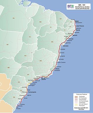
The BR-101 is a longitudinal highway of Brazil. It is the longest in the country with a length of nearly 4,800 km (3,000 mi), and it is considered one of the most important highways in the country, along with BR-116.

The Brazilian Highway System is a network of trunk roads administered by the Ministry of Transport of Brazil. It is constructed, managed and maintained by the National Department of Transport Infrastructure (DNIT), federal agency linked to the Ministry of Infrastructure, and the public works departments of state governments.
The highway system of São Paulo is the largest statewide road transportation system in Brazil, with 34,650 km. It consists of a hugely interconnected network of municipal (11,600 km), state (22,000 km) and federal (1,050 km) roads. More than 90% of the population is within 5 km of a paved road.

Rodovia Ayrton Senna da Silva, is a highway in the state of São Paulo, Brazil.
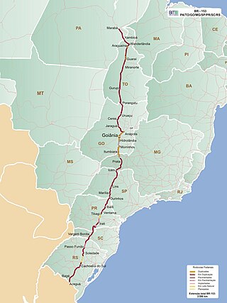
BR-153 is a major federal highway of Brazil, officially named the Transbrasiliana Highway. It also serves as part of the Belém–Brasília Highway in the stretch located between the cities of Wanderlândia, in the state of Tocantins, and Anápolis, in the state of Goiás.

The Rodovia Presidente Dutra,, colloquially known as Via Dutra is a federal highway which runs through the eastern part of the state of São Paulo and southwestern region of the state of Rio de Janeiro. It is the part of the route BR-116 connecting the city of São Paulo to the city of Rio de Janeiro.

BR-163 is a highway in Brazil, going from Tenente Portela, in the state of Rio Grande do Sul, to Santarém, Pará, on 3579 kilometers. It was proposed to pave the road in its entirety part of the Avança Brasil project, which in 2007 was replaced by the Programa de Aceleração do Crescimento. A 51 km long stretch of the highway was finally paved in 2019 in the state of Pará in a cooperation between the Bolsonaro government and the Brazilian army engineering battalion, until the city of Miritituba, leaving only a small part of the highway to be paved on the other side of the Amazon River.

Greater Rio de Janeiro, officially the Rio de Janeiro Metropolitan Region is a large metropolitan area located in Rio de Janeiro state in Brazil, the second largest in Brazil and third largest in South America. It consists of 22 municipalities, including the state capital, Rio de Janeiro.
Transport in São Paulo plays a key role in the daily lives of the people of São Paulo and offers various methods of public transport that are offered in the city, including a complex bus system run by SPTrans, and various subway and railway lines. A contactless smartcard is used to pay fares for the buses, subway, and railway systems. São Paulo also has three airports.
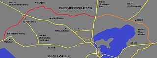
The Arco Metropolitano do Rio de Janeiro is a highway designed to connect the five main highways that cross the municipality of Rio de Janeiro.

BR-040 is a federal highway of Brazil. The 1,139.3 kilometres (707.9 mi) road connects Brasilia to Rio de Janeiro.
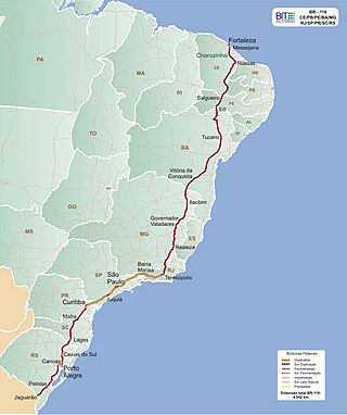
BR-116 is a federal route of highways of Brazil and the longest highway in the country, with 4,542 km (2,822 mi) of extension. The road connect Fortaleza, Ceará, one of the largest Northeast Brazil metropolises, to the southern city of Jaguarão, Rio Grande do Sul, in the border with Uruguay. It is also the longest highway in the country to be completely paved. It is considered one of the most important highways in the country, along with BR-101.

Francisco Prestes Maia (1896–1965) was a Brazilian architect, civil engineer, urban planner, and professor, who served three terms as mayor of the city of São Paulo.

The Port of Rio de Janeiro is a seaport in the city of Rio de Janeiro, Brazil located in a cove on the west shore of Guanabara Bay. It is the third-busiest port in Brazil, and it is managed by Companhia Docas do Rio de Janeiro.

The BR-290 is an important highway in the Rio Grande do Sul state of Brazil. Approximately 726km long, the highway runs from the port city of Osório westward to the city of Uruguaiana, on the border of Argentina.
