Mount Hardy is an 8,099-foot (2,469-metre) mountain summit located on the common border of Okanogan County with Skagit County in Washington state. It is part of the Okanogan Range which is a sub-range of the North Cascades Range. Mount Hardy is situated west of Methow Pass, at headwaters of the Methow River, on land administered by the Okanogan–Wenatchee National Forest. Topographic relief is significant as the summit rises approximately 2,500 feet above the West Fork Methow River in one-half mile (0.8 km). The nearest higher peak is Golden Horn, 1.75 miles (2.82 km) to the northeast. Mount Hardy can be seen from the North Cascades Highway which traverses below the southwestern base of the mountain. This mountain's toponym was officially adopted in 1973 by the United States Board on Geographic Names.

The Needles is an 8,160-foot (2,487-metre) granite mountain located in Okanogan County in Washington state. It is part of the Okanogan Range which is a sub-range of the North Cascades Range. The Needles is situated on land administered by the Okanogan–Wenatchee National Forest. Precipitation runoff from the peak drains into tributaries of the Methow River. Topographic relief is significant as the summit rises 3,660 feet above Pine Creek in approximately 1.25 mile (2 km). The nearest higher neighbor is Tower Mountain, 2.26 miles (3.64 km) to the southwest.

McKay Ridge is a 7,000+ ft ridge located in Whatcom County in Washington state. It is part of the Okanogan Range which is a sub-range of the North Cascades. It's situated north of the North Cascades Highway on land administered by the Okanogan–Wenatchee National Forest. The nearest higher peak is Majestic Mountain, 1.6 miles (2.6 km) to the northeast. Precipitation runoff from the ridge drains to Ross Lake via tributaries of the Skagit River.
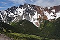
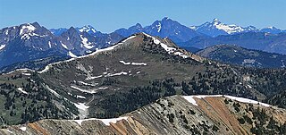
Porcupine Peak is a 7,762-foot-elevation (2,366-meter) mountain located in Skagit County of Washington state.

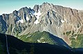
Blackbeard Peak, also spelled Black Beard Peak, is a 7,241-foot mountain summit in the North Cascades in the U.S. state of Washington. It is located in the Okanogan–Wenatchee National Forest in Skagit County. It is situated northwest of Rainy Pass, southwest of Porcupine Peak, and southeast of Graybeard Peak. Its nearest higher neighbor is Repulse Peak, 1.06 mi (1.71 km) to the west. Blackbeard Peak can be seen from the North Cascades Highway. Precipitation runoff from Blackbeard Peak drains into Granite Creek, a tributary of the Skagit River. Topographic relief is significant as the summit rises over 3,000 feet above Granite Creek in one mile (1.6 km).

Crooked Bum is a 6,937-foot-elevation mountain summit on the crest of the North Cascades in the U.S. state of Washington. It is located in the Okanogan–Wenatchee National Forest on the shared border of Skagit County and Chelan County. It is situated immediately west of Rainy Pass and two miles east of Corteo Peak. The scenic and popular Maple Pass Trail traverses the south slope of the peak while staying above Lake Ann. Precipitation runoff from the north slope of Crooked Bum drains into Granite Creek which is a tributary of the Skagit River, whereas the south side drains into Bridge Creek which is a tributary of the Chelan River.

Holliway Mountain is an 8000+ ft granite summit located in Okanogan County in Washington state. It is part of the Okanogan Range which is a sub-range of the North Cascades Range. Holliway Mountain is situated near the headwaters of the Methow River on land administered by the Okanogan–Wenatchee National Forest. The nearest higher peak is Golden Horn, 0.91 miles (1.46 km) to the south. Azurite Peak is located three miles to the north-northwest.
Molar Tooth is a 7,547-foot-elevation (2,300-meter) granite summit located on the shared border of Okanogan County and Skagit County, in Washington state. The mountain is part of the Okanagan Range which is a subrange of the Cascade Range. Set in the Okanogan–Wenatchee National Forest, Molar Tooth is situated south of Cutthroat Pass, and 0.57 miles (0.92 km) north of Cutthroat Peak, which is also the nearest higher peak. The easiest climbing route is class 4 scrambling, but solid rock provides class 5 technical routes as well. Precipitation runoff from the east side of Molar Tooth drains into tributaries of the Methow River, whereas runoff from the west side drains into tributaries of the Skagit River.

Mount Ballard is an 8,371-foot (2,551-metre) double-summit mountain located in eastern Whatcom County of Washington state. It is part of the Okanogan Range which is a sub-range of the North Cascades Range, and the mountain is situated on land administered by the Okanogan–Wenatchee National Forest. Ballard ranks 84th on Washington's highest 100 peaks. The nearest higher neighbor is Azurite Peak, 2.04 miles (3.28 km) to the south. Precipitation runoff from Mount Ballard drains into Mill Creek and Slate Creek, both tributaries of the Skagit River. Topographic relief is significant as the summit rises approximately 4,000 feet above Mill Creek in one mile (1.6 km).

Monument Peak is an 8,597-foot (2,620-metre) mountain summit located in western Okanogan County in Washington state. It is part of the Okanogan Range which is a sub-range of the North Cascades. The mountain is situated in the Pasayten Wilderness, on land administered by the Okanogan–Wenatchee National Forest. The nearest higher peak is Mount Lago, 2.42 miles (3.89 km) to the north. Precipitation runoff from Monument Peak drains east into Monument Creek, and west into Eureka Creek, which are both part of the Methow River drainage basin. Topographic relief is significant as the summit rises 3,800 feet above Eureka Creek in 1.25 mile (2 km).

Remmel Mountain, also known as Mount Remmel, is a prominent 8,685-foot (2,647-metre) mountain summit located in Okanogan County in Washington state. It is the highest point in the Cathedral Range, which is a subrange of the Okanogan Range in the North Cascades. The mountain is situated 5 miles (8.0 km) south of the Canada–United States border, on the eastern side of the Cascade crest, in the Pasayten Wilderness, on land managed by the Okanogan–Wenatchee National Forest. The nearest higher peak is Mount Lago, 16.8 miles (27.0 km) to the west-southwest, and Amphitheater Mountain lies 3.6 miles (5.8 km) to the north. Remmel is the third-highest summit of the Okanogan Range following Mount Lago (8,745 ft), and Robinson Mountain (8,726 ft). These three peaks follow Jack Mountain (9,075 ft) as the highest peaks in the Pasayten Wilderness. Remmel is the most prominent mountain in the Pasayten Wilderness. Topographic relief is significant as the summit rises approximately 2,300 feet above Andrews Creek in 0.75 mile (1.2 km). Precipitation runoff from Remmel Mountain drains into the Chewuch River basin.

Slate Peak is a 7,440-foot (2,270-metre) mountain summit located on the shared border between Okanogan County and Whatcom County in Washington state. It is part of the Okanogan Range, which is a sub-range of the North Cascades. The mountain is situated 15 miles (24 km) northwest of Mazama, on the boundary line of the Pasayten Wilderness, on land managed by the Okanogan–Wenatchee National Forest. The peak has the distinction of having the highest road in Washington, as well as the highest fire lookout. Although the narrow one-lane white-knuckle road reaches the summit of the mountain, the Forest Service gated it to vehicles, which necessitates walking the final few hundred yards. Additionally, the Pacific Crest Trail traverses the west slope of the peak, and the West Fork Pasayten Trail traverses the eastern slope. The nearest higher peak is Devils Peak, 2.57 miles (4.14 km) to the north. Precipitation runoff from Slate Peak drains east into Pasayten River, or west into Slate Creek, which is in the Skagit River drainage basin.

Apex Mountain is an 8,302-foot (2,530-metre) summit located in Okanogan County in Washington state. It is part of the Okanogan Range which is a sub-range of the North Cascades. The mountain is situated 2.5 miles (4.0 km) south of the Canada–United States border, on the east side of the Cascade crest, in the Pasayten Wilderness, on land managed by the Okanogan–Wenatchee National Forest. The nearest higher peak is Amphitheater Mountain, 2.35 miles (3.78 km) to the west-northwest. The Pacific Northwest Trail traverses the northern slopes of Apex Mountain as it crosses Apex Pass. Precipitation runoff from Apex Mountain drains west into Cathedral Creek, or east into Tungsten Creek, both tributaries of the Chewuch River. Topographic relief is significant as the summit rises 1,200 feet above Tungsten Lake in 0.3 mile (0.5 km).

Castle Peak is a prominent 8,343-foot (2,543-metre) mountain summit located in the Hozameen Range of the North Cascades, on the shared border between Okanogan County and Whatcom County of Washington state. The mountain is situated one mile (1.6 km) south of the Canada–United States border, on the Cascade crest, in the Pasayten Wilderness, on land managed by the Okanogan–Wenatchee National Forest. The nearest higher peak is Jack Mountain, 14.8 miles (23.8 km) to the south-southwest. Castle Peak is the second highest summit of the Hozameen Range following Jack Mountain. Castle Peak is the sixth-highest mountain in the Pasayten Wilderness. Precipitation runoff from the mountain drains east into Castle Creek, a tributary of the Similkameen River, or west into tributaries of the Skagit River. Topographic relief is significant as the summit rises nearly 3,000 feet above Crow Creek in 0.75 mile (1.2 km).

Tiffany Mountain is an 8,245-foot (2,513-metre) mountain summit located in Okanogan County in Washington state. It is the highest point in the Tiffany Range, which is a sub-range of the Okanogan Range. The mountain is situated on the east side of the Cascade crest, on land managed by the Okanogan–Wenatchee National Forest. The nearest higher peak is Windy Peak, 18 miles (29 km) to the north. Precipitation runoff from Tiffany Mountain drains into tributaries of the Columbia River.

Skagit Peak is a 6,824-foot (2,080-metre) mountain summit located in the North Cascades, in Whatcom County of Washington state. It is situated on the western side of the Cascade crest, at the western edge of the Pasayten Wilderness, on land managed by the Okanogan–Wenatchee National Forest. Skagit Peak is part of the Hozameen Range, a subset of the North Cascades which also includes Hozomeen Mountain to the north, and Jack Mountain to the south. Precipitation runoff from this mountain drains into the Skagit River via Three Fools Creek and Ross Lake.
Tatie Peak is a 7,386-foot (2,251-metre) mountain summit located on the shared border between Okanogan County and Whatcom County in Washington state. It is part of the Okanogan Range, which is a sub-range of the North Cascades. The mountain is situated 2.6 miles (4.2 km) east of Mount Ballard, and 3.3 miles (5.3 km) south of Slate Peak, on land managed by the Okanogan–Wenatchee National Forest. The nearest higher neighbor is Syncline Mountain, 0.8 miles (1.3 km) to the south-southwest. The Pacific Crest Trail traverses the south slope of the peak, with an easy off-trail scramble to reach the summit. Precipitation runoff from Tatie Peak drains south into Trout Creek which is a tributary of the Methow River, or northwest into Slate Creek, which is part of the Skagit River drainage basin.

Syncline Mountain is a 7,560-foot (2,300-metre) mountain summit located on the shared border between Okanogan County and Whatcom County in Washington state. It is part of the Okanogan Range, which is a sub-range of the North Cascades, and is situated on land managed by the Okanogan–Wenatchee National Forest. Its nearest neighbor is Tatie Peak, 0.8 miles (1.3 km) to the north, and the nearest higher neighbor is Mount Ballard, 2.1 miles (3.4 km) to the west. The Pacific Crest Trail traverses the east slope of the peak, with an off-trail scramble to reach the summit. Precipitation runoff from Syncline Mountain drains east into Trout Creek which is a tributary of the Methow River, or northwest into Slate Creek, which is part of the Skagit River drainage basin. This unofficially named mountain features a conspicuous syncline, hence its descriptive name.
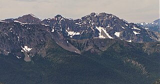
Majestic Mountain is a 7,530-foot-elevation (2,295-meter) mountain summit located in Whatcom County in Washington state.
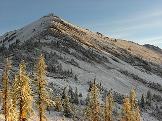
Tamarack Peak is a 7,290-foot (2,222-metre) mountain summit located on the border shared by Okanogan County and Whatcom County in Washington state.