
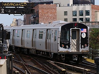
The J Nassau Street Local and Z Nassau Street Express are two rapid transit services in the B Division of the New York City Subway. Their route emblems, or "bullets", are colored brown since they use the BMT Nassau Street Line in Lower Manhattan.
The BMT Jamaica Line, also known as the Broadway - Brooklyn Line, is an elevated rapid transit line of the B Division of the New York City Subway in Brooklyn and Queens. It runs from the Williamsburg Bridge southeast over Broadway to East New York, Brooklyn, and then east over Fulton Street and Jamaica Avenue to Jamaica, Queens. In western Jamaica, the line goes into a tunnel, becoming the lower level of the Archer Avenue lines in central Jamaica. The J and Z trains serve the entire length of the Jamaica Line, and the M serves the line west of Myrtle Avenue.
The M Queens Boulevard/Sixth Avenue Local is a rapid transit service in the B Division of the New York City Subway. Its route emblem, or "bullet", is colored orange since it is a part of the IND Sixth Avenue Line in Manhattan.

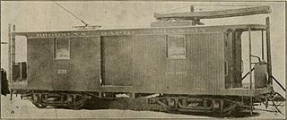
The Brooklyn City Railroad (BCRR) was the oldest and one of the largest operators of streetcars in the City of Brooklyn, New York, continuing in that role when Brooklyn became a borough of New York City in 1898.
The Myrtle Avenue station is a New York City Subway express station on the BMT Jamaica Line. Located at the intersection of Myrtle Avenue and Broadway in Bushwick, Brooklyn. It is served by the J and M trains at all times, and by the Z during rush hours in peak direction.

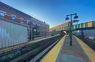
The Marcy Avenue station is a station on the BMT Jamaica Line of the New York City Subway. Located at the intersection of Marcy Avenue and Broadway in Brooklyn, it is served by the J train at all times, the M train at all times except late nights, and the Z train during rush hours in the peak direction.

The Hewes Street station is a local station on the BMT Jamaica Line of the New York City Subway. Located at the intersection of Hewes Street and Broadway in Brooklyn, it is served by the J train at all times except weekdays in the peak direction and the M train at all times except late nights. The Z train skips this station when it operates.

The B54 is a bus route on Myrtle Avenue in Brooklyn, New York City. The line travels between Downtown Brooklyn in the west and Myrtle–Wyckoff Avenues station in the east. The B54 operates from MTA New York City Bus's Fresh Pond Depot in Ridgewood, Queens. The route serves only the section of Myrtle Avenue within Brooklyn; the section within Queens is served by the Q55 bus.

The DeKalb Avenue Line is a public transit line in Brooklyn and Queens, New York City, running mostly along DeKalb Avenue, as well as eastbound on Lafayette Avenue, between Downtown Brooklyn and Ridgewood, Queens. Originally a streetcar line, it is now the B38 DeKalb/Lafayette Avenues bus route, operated by the New York City Transit Authority.
The Brooklyn Heights Railroad was a street railway company in the U.S. state of New York. It leased and operated the streetcar lines of the Brooklyn Rapid Transit Company, but started out with the Montague Street Line, a short cable car line connecting the Wall Street Ferry with downtown Brooklyn along Montague Street. Eliphalet Williams Bliss owned the railroad.

The Bergen Street Line is a public transit line in Brooklyn, New York City, running westbound mostly along Bergen Street, as well as eastbound on Dean Street, between Downtown Brooklyn and Ocean Hill. Originally a streetcar line, it is now the B65 bus route, operated by the New York City Transit Authority. The B65 is based out of the East New York Depot in East New York, Brooklyn.

The Grand Street Line is a public transit line in Brooklyn and Queens, New York City, running mostly along the continuous Grand Street and Grand Avenue between Williamsburg, Brooklyn and Maspeth, Queens. It then continues down Queens Boulevard to the 63rd Drive–Rego Park station. Originally a streetcar line, it is now the Q59 bus route, operated by the New York City Transit Authority between Williamsburg and Rego Park, Queens.

The Wilson Avenue Line is a public transit line in Brooklyn, New York City, running along Wilson Avenue and Rockaway Avenue between Williamsburg and Canarsie. Originally a streetcar line, it is now the B60 bus route, operated by MTA New York City Bus.

The Nassau Electric Railroad was an electric street railway company in the U.S. state of New York. The company operated throughout the borough of Brooklyn, as well as over the Brooklyn Bridge and Williamsburg Bridge into Manhattan.

The B45 is a bus route that constitutes a public transit line operating in Brooklyn, New York City, mainly along Atlantic Avenue, Washington Avenue, Sterling Place, and St. Johns Place between Downtown Brooklyn and Crown Heights. It is operated by the MTA New York City Transit Authority. Its precursor was a streetcar line that began operation in 1877, and was known as the St. Johns Place Line. The route became a bus line in 1947.

The B63 is a bus route in Brooklyn, New York City, running mainly along Fifth Avenue and Atlantic Avenue between Fort Hamilton and Cobble Hill. Originally a streetcar line called the Fifth Avenue Line, it is now operated by the New York City Transit Authority as the Fifth/Atlantic Avenues bus.

The Graham Avenue Line and Tompkins Avenue Line were two public transit lines in Brooklyn, New York City with the Graham Avenue Line running mainly along Graham Avenue and Manhattan Avenue and the Tompkins Avenue Line running mainly along Tompkins Avenue. The Graham Avenue line ran between Downtown Brooklyn and Greenpoint and the Tompkins Avenue Line ran between Prospect Lefferts Gardens and Williamsburg. Originally streetcar lines, they were replaced by the B47 and B62 bus routes which were then combined to form the B43 route which currently operates between Prospect Lefferts Gardens and Greenpoint. The line is dispatched from Jackie Gleason Depot in Sunset Park, Brooklyn.
The B48 bus route constitutes a public transit line in Brooklyn, New York City, running along Lorimer Street, Franklin Avenue, and Classon Avenue between Flatbush and Greenpoint. Originally the Lorimer Street streetcar line, it is now a bus route operated by MTA New York City Bus.

The Williamsburg Bridge Plaza, sometimes called Washington Plaza or the Williamsburg Bridge Transit Center, is a major bus terminal and former trolley terminal located at the foot of the Williamsburg Bridge in the New York City borough of Brooklyn, one block west of the Brooklyn-Queens Expressway (I-278). It is situated by the boundaries of Broadway, Havemeyer Street, Roebling Street, and South 5th Street, south of the LaGuardia Playground. It contains five bus lanes, and serves as a terminal for numerous MTA New York City Transit Authority bus routes of Brooklyn and Queens that start and end their runs there.

The Williamsburg Bridge Trolley Terminal, also called the Essex Street Trolley Terminal or Delancey Street Trolley Terminal, was a trolley terminal located underground adjacent to the Essex Street subway station in the Lower East Side of Manhattan. Passenger trolley service operated through the terminal from 1908 until 1948 when trolley service over the Williamsburg Bridge ended. The station was constructed with balloon loops for turning around streetcars after they crossed over the Williamsburg Bridge to send them back to Brooklyn.
