Bowman Peninsula is a peninsula, 46 kilometres (25 nmi) long in a north-south direction and 28 kilometres (15 nmi) wide in its northern and central portions, lying between Nantucket Inlet and Gardner Inlet on the east coast of Palmer Land. The peninsula is ice covered and narrows toward the south, terminating in Cape Adams. It was discovered by the Ronne Antarctic Research Expedition, 1947–48, under Finn Ronne, who named it for Isaiah Bowman.
La Almarcha is a municipality in Cuenca, Castile-La Mancha, Spain. It has a population of 602.

Głuszyca is a town in Wałbrzych County, Lower Silesian Voivodeship, in south-western Poland. As at 2006, the town has a population of 6,999. It is the seat of the administrative district (gmina) called Gmina Głuszyca, close to the Czech border. The town lies approximately 13 kilometres (8 mi) south-east of Wałbrzych, and 69 kilometres (43 mi) south-west of the regional capital Wrocław.
Mamolar is a municipality and town located in the province of Burgos, Castile and León, Spain. According to the 2004 census (INE), the municipality has a population of 62 inhabitants.

Niechlów is a village in Góra County, Lower Silesian Voivodeship, in south-western Poland. It is the seat of the administrative district (gmina) called Gmina Niechlów. It lies approximately 13 kilometres (8 mi) west of Góra and 78 km (48 mi) north-west of the regional capital Wrocław.
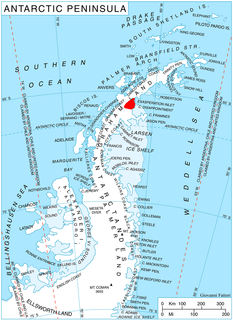
Yates Spur is a prominent rock spur on the south side of Mobiloil Inlet, Bowman Coast, at the west side of the terminus of Earnshaw Glacier. The spur was photographed from the air by Lincoln Ellsworth, 1935, United States Antarctic Service (USAS), 1940, and Ronne Antarctic Research Expedition (RARE), 1947, and was surveyed by Falkland Islands Dependencies Survey (FIDS), 1958. Named by Advisory Committee on Antarctic Names (US-ACAN) in 1977 after D. Kent Yates, Applied Research Laboratories, University of Texas, a member of the United States Geological Survey (USGS) satellite surveying team at Palmer Station, winter party 1973 and a research scientist and programmer with the University of Illinois from 1982 to 2008.
Tanlallé is a village in the Kogho Department of Ganzourgou Province in central Burkina Faso. The village has a population of 778.

Tanjung Dawai is a small town in Kedah, Malaysia. It is located 30 kilometer from Sungai Petani.
Wight Inlet is a body of water in Nunavut's Qikiqtaaluk Region. It lies in western Hudson Strait, forming a wedge into Baffin Island's Meta Incognita Peninsula and the western slopes of the Everett Mountains, is named after Sergeant James Edward Freeman Wight, RNWMP and RCMP #6296.
Barrier Inlet is a body of water in Nunavut's Qikiqtaaluk Region. It lies in western Hudson Strait, forming a wedge into Baffin Island's Meta Incognita Peninsula and the western slopes of the Everett Mountains. Reversing Falls lie near the mouth of the inlet. Shaftesbury Inlet is to the northwest, while Balcom Inlet is to the southeast

Anderton Glacier is a tributary glacier, 7 nautical miles (13 km) long, descending the south slopes of the Eisenhower Range to enter Reeves Glacier between Mount Matz and Andersson Ridge, in Victoria Land, Antarctica. The glacier is situated on the Pennell Coast, a portion of Antarctica lying between Cape Williams and Cape Adare. It was mapped by the United States Geological Survey from surveys and from U.S. Navy air photos, 1955–63, and was named by the Advisory Committee on Antarctic Names for Peter W. Anderton, a glaciologist at McMurdo Station, summer 1965–66.
Stubb Glacier is a glacier 11 nautical miles (20 km) long in Aristotle Mountains on the east coast of Graham Land, flowing east into Scar Inlet between Mount Queequeg and Tashtego Point. The lower reaches of this glacier were surveyed and photographed by the Falkland Islands Dependencies Survey (FIDS) in 1947, and the upper reaches were surveyed in 1955. Named by the United Kingdom Antarctic Place-Names Committee (UK-APC) in 1956 after the second mate on the Pequod in Herman Melville's Moby Dick.

Martel Inlet is an inlet forming the northeast head of Admiralty Bay, King George Island, in the South Shetland Islands off Antarctica. It was charted in December 1909 by the Fourth French Antarctic Expedition under Jean-Baptiste Charcot and named "Fiord Martel" after J.L. Martel, a French politician.
Holoviak Glacier is a glacier flowing west into the head of Mendelssohn Inlet, facing towards the Wilkins Ice Shelf on the north side of the Beethoven Peninsula, lying in the southwestern portion of Alexander Island, Antarctica. It was mapped by the United States Geological Survey from U.S. Navy aerial photographs taken 1967–68 and from Landsat imagery taken 1972–73, and was named by the Advisory Committee on Antarctic Names for Judy C. Holoviak, technical editor, 1964–77, of the Antarctic Research Series, published by the American Geophysical Union, and director of publications for the Union from 1978.
Kay Nunatak is a dark rocky nunatak rising to 500 metres (1,600 ft), situated at the south side of Mobiloil Inlet and forming the northernmost outlier of the Hitchcock Heights, on the east coast of the Antarctic Peninsula. The nunatak was photographed from the air by Sir Hubert Wilkins on December 20, 1928, and by Lincoln Ellsworth in 1935. It was named in 1952 by the Advisory Committee on Antarctic Names for John D. Kay of the American Geographical Society, who by utilizing these photographs assisted in constructing the first reconnaissance map of this area.
Rankin Glacier is a glacier about 12 nautical miles (22 km) long on the east side of Palmer Land. It flows southeast and then east along the south side of Schirmacher Massif to join the Cline Glacier just inland from the head of Odom Inlet. Mapped by United States Geological Survey (USGS) in 1974. Named by Advisory Committee on Antarctic Names (US-ACAN) for John S. Rankin, United States Antarctic Research Program (USARP) biologist on the International Weddell Sea Oceanographic Expeditions, 1968 and 1969.
Kellogg Glacier is a glacier about 9 nautical miles (17 km) long at the base of Condor Peninsula on the east side of Palmer Land, Antarctica. The glacier flows southeast along the north side of Boyer Spur and merges with the north side of Gruening Glacier just inland from the northwest head of Hilton Inlet. It was mapped by the United States Geological Survey (USGS) in 1974, and was named by the Advisory Committee on Antarctic Names for geologist Karl S. Kellogg, a member of the USGS Lassiter Coast party in 1972–73.
Reuning Glacier is a glacier situated on the north side of Beethoven Peninsula, lying within the southwest portion of Alexander Island, Antarctica. The glacier flows in a northwest direction and joins Hushen Glacier in discharging into south Mendelssohn Inlet. The glacier was first mapped by the United States Geological Survey (USGS) from U.S. Navy aerial photographs taken 1967-68 and U.S. Landsat imagery taken 1972-73. Named by Advisory Committee on Antarctic Names (US-ACAN) for Winifred M. Reuning, Office of Polar Programs, National Science Foundation (NSF), Editor, Antarctic Journal of the United States, from 1980.
The Elsinore Trough is a graben rift valley in Riverside County, southern California. It is created by the Elsinore Fault Zone.


