
The Arctic Archipelago, also known as the Canadian Arctic Archipelago, is a group of islands north of the Canadian mainland.
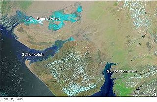
The Gulf of Kutch is an inlet of the Arabian Sea along the west coast of India, in the state of Gujarat, which is renowned for extreme daily tides.
Sella is a municipality in the comarca of Marina Baixa in the province of Alicante, Spain. Every year the first weekend of October Sella celebrates its Festa Major; Festes de l'Aurora.
This is a list of the extreme points of Cyprus: the points that are farther north, south, east or west than any other location.
The Soper River is a waterway on Baffin Island, Nunavut. The river flows over 100 km (62 mi) and then empties into Soper Lake and Pleasant Inlet. The Soper River was designated a Canadian Heritage River in 1992.
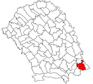
Călărași is a commune in Botoșani County, Romania. It is composed of three villages: Călărași, Libertatea and Pleșani.
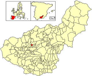
Güevéjar is a municipality located in the province of Granada, Spain. According to the 2005 census (INE), the city has a population of 2018 inhabitants.
Zaidín or Saidí is a municipality located in the province of Huesca, Aragon, Spain. According to the 2004 census (INE), the municipality has a population of 1,721 inhabitants.

Aeronaut Glacier is a low gradient glacier extending 25-mile (40 km) draining northeast from Gair Mesa into the upper part of Aviator Glacier near Navigator Nunatak, situated on the Borchgrevink Coast, named for Anglo-Norwegian explorer Carsten Borchgrevink (1864-1934) in the western extremity of Victoria Land, Antarctica. It was named by the northern party of New Zealand Geological Survey Antarctic Expedition of 1962–63 to commemorate the air support provided by U.S. Navy Squadron VX-6, and in association with nearby Aviator Glacier.
Barrier Inlet is a body of water in Nunavut's Qikiqtaaluk Region. It lies in western Hudson Strait, forming a wedge into Baffin Island's Meta Incognita Peninsula and the western slopes of the Everett Mountains. Reversing Falls lie near the mouth of the inlet. Shaftesbury Inlet is to the northwest, while Balcom Inlet is to the southeast
Mackenzie Bay is a natural inlet in northern Canada, named for the explorer Sir Alexander Mackenzie. It is an arm of the Beaufort Sea. To the west is Herschel Island and the Yukon mainland. To the east is Richards Island, Northwest Territories.

Kasba Tadla is a town in Béni-Mellal Province, Béni Mellal-Khénifra, Morocco. According to the 2004 census it has a population of 40,898.
Britten Inlet is an ice-filled inlet and the only inlet on Monteverdi Peninsula indenting the southwest side of the Peninsula, south Alexander Island, Antarctica. The inlet was delineated from U.S. Landsat imagery of January 1973. In association with the names of composers grouped in this area, it was named by the UK Antarctic Place-Names Committee, 1977, after Benjamin Britten, the British composer.
Kujira Point is a small point forming the northern extremity of Padda Island in Lützow-Holm Bay, Antarctica. It was mapped by Norwegian cartographers from air photos taken by the Lars Christensen Expedition, 1936–37, was remapped by the Japanese Antarctic Research Expedition, 1957–62, and named Kujira-misaki.
Morgan Inlet is an ice-filled inlet about 18 nautical miles (33 km) long, with two branches, indenting the east end of Thurston Island, Antarctica, between Lofgren Peninsula and Tierney Peninsula. The south side of the larger north arm of the inlet is an area of icy rock exposures called the King Cliffs. The east extremity of the wedge-shaped promontory between Lofgren Peninsula and Tierney Peninsula is called Ryan Point.

Marck Glacier is a glacier flowing into the southwestern extremity of Cadwalader Inlet on the north side of Thurston Island, Antarctica. It was named by the Advisory Committee on Antarctic Names after Aviation Machinist's Mate George H. Marck, an aircrewman in the Eastern Group of U.S. Navy Operation Highjump, which obtained aerial photographs of Thurston Island and adjacent coastal areas in the summer of 1946–47.
Ternyck Needle is a conspicuous nunatak, 365 metres (1,198 ft) high, standing 1.5 nautical miles (2.8 km) east of the head of Martel Inlet at the base of the small peninsula separating Admiralty and King George Bays, on King George Island in the South Shetland Islands. It was charted in December 1909 by the French Antarctic Expedition under J.B. Charcot, who presumably applied the name. It was first climbed in 1949 by Geoff Hattersley-Smith and Ken Pawson of the Falkland Islands Dependencies Survey.
Verdi Inlet is an ice-filled inlet lying between Pesce Peninsula and Harris Peninsula, on the north side of the Beethoven Peninsula, situated in the southwest portion of Alexander Island, Antarctica. The inlet was observed from the air and first roughly mapped by the Ronne Antarctic Research Expedition in 1947-48. Remapped from the RARE air photos by Searle of the Falkland Islands Dependencies Survey in 1960. Named by United Kingdom Antarctic Place-Names Committee after Giuseppe Verdi (1813–1901), Italian opera composer.
Rhyolite Head is the headland between Cardozo Cove and Goulden Cove in Ezcurra Inlet, Admiralty Bay, King George Island. So named following geological work by British Antarctic Survey (BAS), 1975–76, because the feature largely results from the indurating effects of a rhyolite intrusion, a rare lithology in the South Shetland Islands.


