
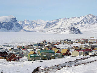
Iqaluit, meaning "place of fish", is the capital of the Canadian territory of Nunavut, its largest community, and its only city. It was known as Frobisher Bay from 1942 to 1987, after the large bay on the coast of which the city is situated, when the traditional Inuktitut name was restored.

The Royal Canadian Mounted Police is the federal and national police force of Canada. The RCMP provides law enforcement at the federal level. It also provides provincial policing in eight of Canada's provinces and local policing on contract basis in the three territories and more than 150 municipalities, 600 aboriginal communities, and three international airports. The RCMP does not provide provincial or municipal policing in Ontario or Quebec.

Victoria Island is a large island in the Canadian Arctic Archipelago that straddles the boundary between Nunavut and the Northwest Territories of Canada. It is the eighth largest island in the world, and at 217,291 km2 (83,897 sq mi) in area, it is Canada's second largest island. It is nearly double the size of Newfoundland (111,390 km2 [43,008 sq mi]), and is slightly larger than the island of Great Britain (209,331 km2 [80,823 sq mi]) but smaller than Honshu (225,800 km2 [87,182 sq mi]). It contains the world's largest island within an island within an island. The western third of the island belongs to the Inuvik Region in the Northwest Territories; the remainder is part of Nunavut's Kitikmeot Region.

The Arctic Archipelago, also known as the Canadian Arctic Archipelago, is a group of islands north of the Canadian mainland.

Ukkusiksalik National Park is a national park in Nunavut, Canada. It covers 20,885 square kilometres (8,064 sq mi) of tundra and coastal mudflats south of the Arctic Circle and the hamlet of Repulse Bay, from Hudson Bay's Roes Welcome Sound towards the western Barrenlands and the source of Brown River. The park surrounds Wager Bay, a 100 kilometres (62 mi)-long inlet on the Hudson Bay. Although the smallest of Nunavut's four national parks, it is the sixth largest in Canada. Its name relates to steatite found there: Ukkusiksalik means "where there is material for the stone pot".
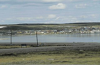
Pangnirtung is an Inuit hamlet, Qikiqtaaluk Region, in the Canadian territory of Nunavut, located on Baffin Island. As of the 2016 census the population was 1,481, an increase of 3.9% from the 2011 census. The area of the town is 7.77 km2 (3.00 sq mi). Pangnirtung is situated on a coastal plain at the coast of Pangnirtung Fjord, a fjord which eventually merges with Cumberland Sound. As of January 2014, the mayor is Mosesee Qappik.

Kitikmeot Region is an administrative region of Nunavut, Canada. It consists of the southern and eastern parts of Victoria Island with the adjacent part of the mainland as far as the Boothia Peninsula, together with King William Island and the southern portion of Prince of Wales Island. The regional seat is Cambridge Bay.
Peter Taqtu Irniq is an Inuk politician in Canada, who served as the second Commissioner of Nunavut from April 2000 to April 2005.
Baker Lake is a hamlet in the Kivalliq Region, in Nunavut on mainland Canada. Located 320 km (200 mi) inland from Hudson Bay, it is near the nation's geographical centre, and is notable for being the Canadian Arctic's sole inland community. The hamlet is located at the mouth of the Thelon River on the shore of Baker Lake. The community was given its English name in 1761 from Captain William Christopher who named it after Sir William Baker, the 11th Governor of the Hudson's Bay Company.

The Thelon River stretches 900 kilometres (560 mi) across northern Canada. Its source is Whitefish Lake in the Northwest Territories, and it flows east to Baker Lake in Nunavut. The Thelon ultimately drains into Hudson Bay at Chesterfield Inlet.

Bathurst Inlet,, is a small Inuit community located in Bathurst Inlet in the Kitikmeot Region of Nunavut, Canada. As of the 2016 census the population remained at zero.

Dubawnt Lake is a lake in Kivalliq Region, Nunavut, Canada. It is 3,630 km2 (1,400 sq mi) in size and has several islands. It is about 200 miles north of the point where Manitoba, Saskatchewan and Nunavut come together, about 300 miles west of Hudson Bay and about 250 miles south of the Arctic Circle. To the northwest is the Thelon Wildlife Sanctuary. Its main inlet and outlet is the north-flowing Dubawnt River which joins the Thelon River at Beverly Lake (Nunavut). The Thelon flows east to Hudson Bay at Chesterfield Inlet. It is on the line of contact between the Sayisi Dene band of Eastern Caribou-Eater Chipewyan people and the Harvaqtuurmiut and Ihalmiut bands of Caribou Inuit. The first European to reach the lake was Samuel Hearne in 1770, but it remained largely unknown to outsiders until it was explored by Joseph Tyrrell in 1893. There are no permanent settlements but there are fly-in fish camps where large lake trout can be caught during the 2-month ice-free season.
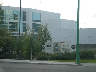
Joint Task Force (North) is responsible for all Canadian Armed Forces operations and administration in northern Canada, namely the Yukon, Northwest Territories, Nunavut and the waters of the Arctic Ocean and Hudson Bay. JTFN is headquartered in Yellowknife, Northwest Territories, and is part of Canadian Joint Operations Command.
Barrier Inlet is a body of water in Nunavut's Qikiqtaaluk Region. It lies in western Hudson Strait, forming a wedge into Baffin Island's Meta Incognita Peninsula and the western slopes of the Everett Mountains. Reversing Falls lie near the mouth of the inlet. Shaftesbury Inlet is to the northwest, while Balcom Inlet is to the southeast

Apex is a small community in Iqaluit located on Baffin Island in Nunavut, Canada. It is about 5 km (3.1 mi) southeast of Iqaluit on a small peninsula separating Koojesse (Kuujussi) Inlet from Tarr Inlet. Historically Apex was the place where most Inuit lived when Iqaluit was a military site and off-limits to anyone not working at the base. The community is accessed by bridge or causeway, and bordered by a local creek (kuujuusi) and waterfall (kugluktuk). Located here are the women's shelter, a church, Nanook Elementary School, and a bed-and-breakfast, along with housing for about 60 families.

Dundas Harbour is an abandoned settlement in Qikiqtaaluk, Nunavut, Canada. It is located on Devon Island at the eastern shore of the waterway also named Dundas Harbour. Baffin Bay's Croker Bay is immediately to the west.
The Saskatchewan Provincial Police was a police force in the Canadian province of Saskatchewan that existed from 1917 until 1928 under the Saskatchewan Provincial Police Act.

Francis Joseph Fitzgerald was a Nova Scotian who became a celebrated Boer War veteran and the first commander of the Royal Northwest Mounted Police detachment at Herschel Island in the Western Arctic (1903). From December 1910 until February 1911, he led a mail patrol from Fort McPherson southward to Dawson City. When the patrol did not arrive in time, a search party, led by Corporal William Dempster, was sent from Dawson City and found the bodies of Fitzgerald and the other patrol members. The trip became known as "The Lost Patrol" and as "one of Yukon’s greatest tragedies."
Honored in Places Remembered Mounties Across Canada William J. Hulgaard and John W White Pages 180, 181


