Bald Hill, Oklahoma

Last updated

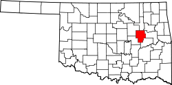
Bald Hill, or Baldhill, [1] is a community in Okmulgee County, Oklahoma. [2] [3] It is located about 15 miles northeast of the City of Okmulgee, the county seat, off of Oklahoma State Highway 16. [4] A post office was established here in 1896, but was closed in 1908. [1] Nevertheless, the town was fueled by oil money, and had a population of 150 in 1923. [1]

Bald Hill was the location of a mansion on a high hill belonging to Enos Wilson. [1] [5] Wilson was recognized in 1935 by the Superintendent of the Five Civilized Tribes as then being the “world’s richest Indian.” [5] A paper referred to the mansion as “his famous peak castle.” [5]

Bald Hill is now considered a ghost town. [1]

Related Research Articles

<span class="mw-page-title-main">Okmulgee County, Oklahoma</span> County in Oklahoma, United States

Okmulgee County is a county in the U.S. state of Oklahoma. As of the 2020 census, the population was 36,706. The county seat is Okmulgee. Located within the Muscogee Nation Reservation, the county was created at statehood in 1907. The name Okmulgee is derived from the Hitchita word okimulgi, meaning "boiling waters".

<span class="mw-page-title-main">McIntosh County, Oklahoma</span> County in Oklahoma, United States

McIntosh County is a county located in the U.S. state of Oklahoma. As of the 2020 census, the population was 18,941. Its county seat is Eufaula. The county is named for an influential Muscogee Creek family, whose members led the migration of the Lower Towns to Indian Territory and served as leaders for generations.

<span class="mw-page-title-main">Lindsay, Oklahoma</span> City in Oklahoma, United States

Lindsay is a city in Garvin County, Oklahoma, United States. The population was 2,840 at the 2010 census. It once promoted itself as "The Broomcorn Capital of the World" but no longer uses that slogan, as broomcorn is no longer raised in the area.

<span class="mw-page-title-main">Dewar, Oklahoma</span> Town in Oklahoma, United States

Dewar is a town in Okmulgee County, Oklahoma, United States. The population was 818 at the 2010 census, a decline of 11.0 percent from the figure of 919 recorded in 2000. Founded in 1909 by workers for the Missouri, Oklahoma and Gulf Railway (MO&G), it was named for William Peter Dewar, a railroad official. It incorporated in 1909.

<span class="mw-page-title-main">Grayson, Oklahoma</span> Town in Oklahoma, United States

Grayson is a town in Okmulgee County, Oklahoma, United States. The population was 159 at the 2010 census, an increase of 18.7 percent from the figure of 134 recorded in 2000.

<span class="mw-page-title-main">Henryetta, Oklahoma</span> City in Oklahoma, United States

Henryetta is a city in Okmulgee County, Oklahoma, United States. The population was 5,927 at the 2010 census, down 2.8 percent from the figure of 6,096 recorded in 2000.

<span class="mw-page-title-main">Morris, Oklahoma</span> City in Oklahoma, United States

Morris is a city in Okmulgee County, Oklahoma, United States. The population was 1,494 at the 2010 census, an increase of 14.3% from the figure of 1,294 recorded in 2000.

<span class="mw-page-title-main">Okmulgee, Oklahoma</span> City in Oklahoma, United States

Okmulgee is a city in, and the county seat of, Okmulgee County, Oklahoma. The name is from the Mvskoke word okimulgee, which means "boiling waters". The site was chosen because of the nearby rivers and springs. Okmulgee is 38 miles south of Tulsa and 13 miles north of Henryetta via US-75. Okmulgee is part of the Tulsa Metropolitan Area.

<span class="mw-page-title-main">Schulter, Oklahoma</span> Town in Oklahoma, United States

Schulter is a town in Okmulgee County, Oklahoma, United States. The population was 509 at the 2010 census, a decrease of 15.2 percent from the figure of 600 recorded in 2000.

<span class="mw-page-title-main">Deep Fork River</span>

The Deep Fork River is an Oklahoma tributary of the North Canadian River. The headwaters flow from northern Oklahoma City and the river empties into the North Canadian River, now impounded by Lake Eufaula.

<span class="mw-page-title-main">Oklahoma's 2nd congressional district</span> U.S. House district for Oklahoma

Oklahoma's 2nd congressional district is one of five United States congressional districts in Oklahoma and covers approximately one-fourth of the state in the east. The district borders Arkansas, Kansas, Missouri, and Texas and includes a total of 24 counties.

<span class="mw-page-title-main">Liberty, Oklahoma</span> Town in Oklahoma, United States

Liberty is a town that sits astride the line dividing Okmulgee and Tulsa counties in the U.S. state of Oklahoma. As of the 2020 census, the population is 153.

Eram is an unincorporated community in Okmulgee County in the U.S. state of Oklahoma. It is located approximately five miles east of Morris, to the north of US Highway 62. The town had a post office starting in 1913, but ending in 1950.

Coalton is a populated place in Okmulgee County, Oklahoma. It is less than 11 miles south of the City of Okmulgee, and just east of US Route 62/US Route 75. In the Henryetta Coal Formation coal-mining region and an oil-producing area, the town in its heyday had its own newspaper, The Coalton Enterprise, and was along the route of the shortline Coalton Railway, later called the Okmulgee Northern Railway, which operated from Okmulgee south along the Deep Fork River carrying the coal out of the Coalton, Schulter and Dewar producing areas from 1916 to 1964. The Thirty-sixth annual report of the Department of Mines and Minerals from 1943 shows production by two coal companies in Coalton—Coalton Coal Company and Davis Coal Company—of almost 17,000 tons annually.

Kusa is a populated place located in Okmulgee County, Oklahoma, about 4 miles east-northeast of Henryetta. Officially incorporated March 27th, 1916, and located in the Henryetta Coal Mining District, Kusa became a coal mining and lead smelting boomtown, complete with movie theaters, hotels, and banks. It even had its own newspaper, The Kusa Industrial, which published between 1914 and 1920. The population grew to a size of about 3,500, making it the largest town in the county at one point.

Spelter City is a populated place within the city of Henryetta, Oklahoma. It is located northeast of Henryetta’s town center, and west of Dewar, Oklahoma.

Natura is a populated place in Okmulgee County, Oklahoma. It is located about 10 miles north of the City of Okmulgee off State Highway 16, east of both the town of Beggs and US-75.

Dighton is a populated place in Okmulgee County, Oklahoma. It is about 7 miles east-northeast of Henryetta, Oklahoma, and is located south of US Route 266 on Bartlett Road.

Wilson, is an unincorporated community in Okmulgee County, Oklahoma, located about 7 miles northwest of the center of Henryetta, Oklahoma, located off Wilson Road. This is not to be confused with the Wilson in Carter County, Oklahoma southeast of Healdton nor the Wilson in Pushmataha County, Oklahoma.

Gulftown is a unincorporated community in Okmulgee County, Oklahoma, at an elevation of 610 feet. It is located about two miles east of Dewar, Oklahoma. It is centered around the corner of Hackberry Road and Arbeka Road, being both south and east of US Route 266.

References

  1. 1 2 3 4 5 Carson, Mary L. (1987). A Guide to Treasure in Oklahoma, Volume 3. Carson Enterprises Inc. p. 336-339. ISBN   0-941620-38-7.
  2. "Bald Hill". Geographic Names Information System . United States Geological Survey, United States Department of the Interior . Retrieved June 13, 2021.
  3. "Bald Hill, Oklahoma". RoadsideThoughts. Retrieved May 31, 2021.
  4. "Okmulgee, Oklahoma to Bald Hill, Oklahoma". Google Maps. Retrieved May 31, 2021.
  5. 1 2 3 "Enos Wilson Accorded Title of 'Richest Indian'". Daily Illini, July 3, 1935 (accessed on Illinois Digital Newspaper Collections). Retrieved May 31, 2021.

35°44′25″N95°50′14″W / 35.74028°N 95.83722°W / 35.74028; -95.83722