Beggs, Oklahoma

Last updated

Beggs, Oklahoma
City
OKMap-doton-Beggs.PNG
Location of Beggs, Oklahoma
Coordinates: 35°45′20″N96°01′18″W / 35.75556°N 96.02167°W / 35.75556; -96.02167
CountryUnited States
State Oklahoma
County Okmulgee
Area
[1]
  Total4.20 sq mi (10.88 km2)
  Land4.20 sq mi (10.87 km2)
  Water0.00 sq mi (0.01 km2)
Elevation
[2]
866 ft (264 m)
Population
 (2020)
  Total1,179
  Density280.98/sq mi (108.49/km2)
Time zone UTC-6 (Central (CST))
  Summer (DST) UTC-5 (CDT)
ZIP code
74421
Area codes 539/918
FIPS code 40-05000 [3]
GNIS feature ID2409813 [2]

Beggs is a city in Okmulgee County, Oklahoma, United States. The population was 1,179 as of the 2020 census. [4] Beggs was named for C.H. Beggs, vice president of the St. Louis-San Francisco (Frisco) Railway. [5]

Contents

History

Starting as a Frisco railroad stop in 1899, Beggs officially became a town on September 15, 1900, when its post office opened. [6] It originally was a center for hog, cattle, and horse ranches in the area. [6] In 1918, oil was discovered just to the west, and Beggs became an oil boomtown until circa 1926. [6] After that, corn, cotton, pecans, and stock raising became important local industries, but Beggs went into a gradual decline, going from an official population of 2,327 in 1920 to 1,531 in 1930 and 1,107 in 1970. [6] The population has since shown some upward fluctuation, settling at 1,179 as of the 2020 Census. [7]

Isparhecher House and Grave is among the National Register of Historic Places listings in Okmulgee County, Oklahoma, and is located approximately four miles west of town off State Highway 16 on private land.

Despite its size, Beggs has at least seven churches. [lower-alpha 1]

Geography

Beggs is located approximately 30 miles south of downtown Tulsa [8] and four miles west of U.S. Route 75, a major national north–south artery. U.S. Route 75 Alternate, the only such bannered route stemming from U.S. Route 75, is largely along the former alignment of the old Highway 75 prior to 1959, and travels from U.S. 75 west to Beggs, along SH-16, before turning north along said former alignment and continuing to Sapulpa. The former alignment running directly south from Beggs to Okmulgee is known as Old Highway 75. The major east–west route through Beggs is Oklahoma State Highway 16.

According to the United States Census Bureau, the city has a total area of 4.3 square miles (11 km2), all land.

Demographics

Historical population
CensusPop.Note
1910 855
1920 2,327172.2%
1930 1,531−34.2%
1940 1,283−16.2%
1950 1,214−5.4%
1960 1,114−8.2%
1970 1,107−0.6%
1980 1,42829.0%
1990 1,150−19.5%
2000 1,36418.6%
2010 1,321−3.2%
2020 1,179−10.7%
U.S. Decennial Census [9]

As of the census [3] of 2000, there were 1,364 people, 538 households, and 363 families residing in the city. The population density was 320.3 inhabitants per square mile (123.7/km2). There were 608 housing units at an average density of 142.8 per square mile (55.1/km2). The racial makeup of the city was 59.53% White, 21.70% African American, 9.75% Native American, 0.15% from other races, and 8.87% from two or more races. Hispanic or Latino of any race were 1.25% of the population.

There were 538 households, out of which 33.5% had children under the age of 18 living with them, 47.2% were married couples living together, 17.1% had a female householder with no husband present, and 32.5% were non-families. 30.7% of all households were made up of individuals, and 15.2% had someone living alone who was 65 years of age or older. The average household size was 2.51 and the average family size was 3.13.

In the city, the population was spread out, with 28.8% under the age of 18, 9.3% from 18 to 24, 26.5% from 25 to 44, 22.1% from 45 to 64, and 13.3% who were 65 years of age or older. The median age was 35 years. For every 100 females, there were 89.4 males. For every 100 females age 18 and over, there were 82.5 males.

The median income for a household in the city was $25,063, and the median income for a family was $31,250. Males had a median income of $26,150 versus $22,143 for females. The per capita income for the city was $12,191. About 16.9% of families and 18.4% of the population were below the poverty line, including 20.1% of those under age 18 and 29.3% of those age 65 or over.

Recreation

Recreational opportunities include Old Beggs Lake, southeast of the town center, [10] and the larger New Beggs Lake, almost directly east of the town center. [11]

A city playground on Main Street was revitalized as Legacy Park in the 2019–2020 timeframe, complete with playground equipment, a pavilion, and picnic tables. [12]

Beggs Fairgrounds and Round-Up Club Arena is a fairgrounds and rodeo arena, available for special events. [13]

Notable people

Beggs attracted national attention in the late 1970s when public pay phones offering calls for only five cents had long since been phased out across the country, but Beggs still had them. [15] [16] In the 21st century, pay phones of any cost began to be phased out across the country by AT&T in 2007 and Verizon in 2011. [17] But as of mid-2022, Beggs still has nickel public pay phones, maintained by the Beggs Telephone Company. [18] [19]

Beggs features prominently in The Great War: American Front , the second volume of the Southern Victory alternate history novels by author Harry Turtledove.

Beggs was one of the filming sites for principal photography on Season One of the FX comedy series Reservation Dogs from filmmaker Sterlin Harjo, which concerns four Native American teens in rural Oklahoma. [20]

Notes

  1. Churches include: Crossroads Baptist Church at 6962 Happy Camp Rd; First Baptist Church South at 8150 Highway 16; First United Methodist Church at 506 N Broadway; Beggs First Assembly of God at the corner of 400 East Main at Cherokee street; First Apostolic Church at 302 West 3rd Street; Church of Christ at Fifth & Osage; and, Handy Chapel A.M.E. Church at E 1st St & S Broadway St.

Related Research Articles

<span class="mw-page-title-main">Tulsa County, Oklahoma</span> County in the United States

Tulsa County is located in the U.S. state of Oklahoma. As of the 2020 census, the population was 669,279, making it the second-most populous county in the state, behind only Oklahoma County. Its county seat and largest city is Tulsa, the second-largest city in the state. Founded at statehood, in 1907, it was named after the previously established city of Tulsa. Before statehood, the area was part of both the Creek Nation and the Cooweescoowee District of Cherokee Nation in Indian Territory.

<span class="mw-page-title-main">Okmulgee County, Oklahoma</span> County in Oklahoma, United States

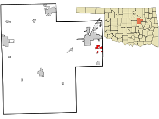
Okmulgee County is a county in the U.S. state of Oklahoma. As of the 2020 census, the population was 36,706. The county seat is Okmulgee. Located within the Muscogee Nation Reservation, the county was created at statehood in 1907. The name Okmulgee is derived from the Hitchita word okimulgi, meaning "boiling waters".

<span class="mw-page-title-main">Creek County, Oklahoma</span> County in Oklahoma, United States

Creek County is a county located in the U.S. state of Oklahoma. As of the 2020 census, the population was 71,754. Its county seat is Sapulpa.

<span class="mw-page-title-main">Vinita, Oklahoma</span> City in Oklahoma, United States

Vinita is a city and county seat of Craig County, Oklahoma, United States. As of the 2020 census, the population was 5,193.

<span class="mw-page-title-main">Bristow, Oklahoma</span> City in Oklahoma, United States

Bristow is a city in Creek County, Oklahoma, United States. The population was 4,222 at the 2010 census, down 2.4 percent from the figure of 4,325 recorded in 2000.

<span class="mw-page-title-main">Kellyville, Oklahoma</span> Town in Oklahoma, United States

Kellyville is a town in Creek County, Oklahoma, United States. The population was 1,019 at the 2020 census.

<span class="mw-page-title-main">Kiefer, Oklahoma</span> Town in Oklahoma, United States

Kiefer is a town in Creek County, Oklahoma, United States. The population was 2,187 at the 2020 census, a 30% increase over the 1,685 population recorded at the 2010 census, which itself was a 64 percent increase over the 1,026 figure recorded in 2000.

<span class="mw-page-title-main">Mounds, Oklahoma</span> Town in Oklahoma, United States

Mounds is a town in Creek County, Oklahoma, United States. It is located just south of Tulsa; the town's population was 932 at the 2020 census.

<span class="mw-page-title-main">Pryor Creek, Oklahoma</span> City in Oklahoma, United States

Pryor Creek or Pryor is a city in and county seat of Mayes County, Oklahoma, United States. The population was 8,659 at the 2000 census and 9,539 in the 2010 census.

<span class="mw-page-title-main">Grayson, Oklahoma</span> Town in Oklahoma, United States

Grayson is a town in Okmulgee County, Oklahoma, United States. The population was 127 at the 2020 census.

<span class="mw-page-title-main">Henryetta, Oklahoma</span> City in Oklahoma, United States

Henryetta is a city in Okmulgee County, Oklahoma, United States. The population was 5,640 at the 2020 census.

<span class="mw-page-title-main">Morris, Oklahoma</span> City in Oklahoma, United States

Morris is a city in Okmulgee County, Oklahoma, United States. The population was 1,299 at the 2020 census.

<span class="mw-page-title-main">Okmulgee, Oklahoma</span> City in Oklahoma, United States

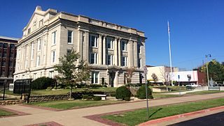
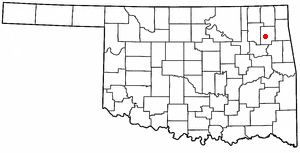
Okmulgee is a city in, and the county seat of, Okmulgee County, Oklahoma, United States, and is part of the Tulsa Metropolitan Area. The name is from the Mvskoke word okimulgee, which means "boiling waters". The site was chosen because of the nearby rivers and springs. Okmulgee is 38 miles south of Tulsa and 13 miles north of Henryetta via US-75.

<span class="mw-page-title-main">Schulter, Oklahoma</span> Town in Oklahoma, United States

Schulter is a town in Okmulgee County, Oklahoma, United States. The population was 422 at the time of the 2020 census.

<span class="mw-page-title-main">Winchester, Oklahoma</span> Town in Oklahoma, United States

Winchester is a town in Okmulgee County, Oklahoma, United States. The population was 546 at the 2020 census, an increase of 5.8% from the figure of 516 recorded in 2010. It is a recently built residential community, having incorporated February 18, 1974.

<span class="mw-page-title-main">Terlton, Oklahoma</span> Town in Oklahoma, United States

Terlton is a town in Pawnee County, Oklahoma, United States. It is located one-half mile south of US 412/US 64 on Terlton Road and County Road E0570. The population was 77 at the time of the 2020 Census.

<span class="mw-page-title-main">Seminole, Oklahoma</span> City in Oklahoma, United States

Seminole is a city in Seminole County, Oklahoma, United States. The population was 7,488 at the 2010 census. Seminole experienced a large population growth in the 1920s due to an oil boom.

<span class="mw-page-title-main">Tulsa metropolitan area</span> Metropolitan area in northeastern Oklahoma

The Tulsa metropolitan area, officially defined as the Tulsa metropolitan statistical area is a metropolis in northeastern Oklahoma centered around the city of Tulsa and encompassing Tulsa, Rogers, Wagoner, Osage, Creek, Okmulgee and Pawnee counties. It had a population of 1,034,123 according to the 2022 U.S. census estimates.

<span class="mw-page-title-main">Liberty, Oklahoma</span> Town in Oklahoma, United States

Liberty is a town that sits astride the line dividing Okmulgee and Tulsa counties in the U.S. state of Oklahoma. As of the 2020 census, the population is 153.

<span class="mw-page-title-main">U.S. Route 75 Alternate (Beggs–Sapulpa, Oklahoma)</span> Alternate highway route in Oklahoma, United States

U.S. 75 Alternate is a 30.15-mile (48.52 km) highway near Tulsa. The southern terminus is at U.S. Highway 75 and SH-16 east of Beggs. The northern terminus is signed at State Highway 66 and State Highway 97 in Sapulpa. However, the highway continues unsigned along SH-66, ending at the north terminus of the Turner Turnpike, where SH-66 merges onto the free portion of I-44. It runs parallel to US-75 for its entire length.

References

  1. "ArcGIS REST Services Directory". United States Census Bureau. Retrieved September 20, 2022.
  2. 1 2 U.S. Geological Survey Geographic Names Information System: Beggs, Oklahoma
  3. 1 2 "U.S. Census website". United States Census Bureau . Retrieved January 31, 2008.
  4. "Beggs city, Oklahoma". United States Census Bureau. Retrieved March 20, 2023.
  5. "ePodunk Beggs Community Profile" . Retrieved June 15, 2011.
  6. 1 2 3 4 Davidson, Ruth. "Beggs," Encyclopedia of Oklahoma History & Culture, Oklahoma Historical Society. Accessed February 17, 2016.
  7. "Beggs city, Oklahoma". United States Census Bureau. Retrieved March 20, 2023.
  8. "Mapquest website" . Retrieved September 27, 2019.
  9. "Census of Population and Housing". Census.gov. Retrieved June 4, 2015.
  10. "Old Beggs Lake Rd to Beggs, Oklahoma". Google Maps. Retrieved December 27, 2020.
  11. "New Beggs Lake to Beggs, Oklahoma". Google Maps. Retrieved December 27, 2020.
  12. "Legacy Park-Beggs". Facebook. Retrieved May 27, 2020.
  13. "Beggs Fairgrounds & Round Up Club". locationshub. Retrieved July 14, 2020.
  14. (http://www.nfl.com/player/rodneytate/2527042/careerstats)
  15. "'Deposit One Nickel, Please'". The Argus-Press, August 20. 1977. Retrieved July 17, 2020.
  16. "Five-Cent Phone Calls Ending in Louisiana". The New York Times. December 21, 1978. Retrieved July 17, 2020.
  17. "What Killed the Pay Phone?". Renee Reizman, The Atlantic, February 2, 2017. February 2, 2017. Retrieved July 17, 2020.
  18. "Home Page". Beggs Telephone Company. Retrieved July 17, 2020.
  19. "Oklahoma family finds working pay phone in Beggs". KJRH Tulsa, June 14, 2022. Retrieved June 15, 2022.
  20. "Shot-in-Oklahoma FX series 'Reservation Dogs' set for Aug. 9 debut". Tulsa World, July 16, 2021. July 16, 2021. Retrieved July 16, 2021.