Preston, Oklahoma | |
|---|---|
 Preston High School (2025) | |
 Preston, Oklahoma Location within Oklahoma  Preston, Oklahoma Preston, Oklahoma (the United States) | |
| Coordinates: 35°42′41″N95°59′20″W / 35.71139°N 95.98889°W [1] | |
| Country | United States |
| State | Oklahoma |
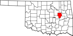
| County | Okmulgee |
| Area | |
• Total | 0.46 sq mi (1.18 km2) |
| • Land | 0.46 sq mi (1.18 km2) |
| • Water | 0 sq mi (0.00 km2) |
| Elevation | 791 ft (241 m) |
| Population (2020) | |
• Total | 169 |
| • Density | 371/sq mi (143/km2) |
| Time zone | UTC−6 (CST) |
| • Summer (DST) | UTC−5 (CDT) |
| ZIP Code | 74456 |
| FIPS code | 40-60650 [1] |
| GNIS ID | 2805349 [1] |
Preston is an unincorporated community located in Okmulgee County, Oklahoma, United States. [1] The population was 169 at the 2020 census. [3]