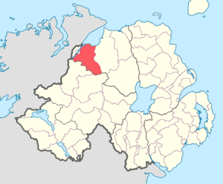
County Londonderry, also known as County Derry, is one of the six counties of Northern Ireland, one of the thirty-two counties of Ireland and one of the nine counties of Ulster. Before the partition of Ireland, it was one of the counties of the Kingdom of Ireland from 1613 onward and then of the United Kingdom after the Acts of Union 1800. Adjoining the north-west shore of Lough Neagh, the county covers an area of 2,118 km2 (818 sq mi) and today has a population of about 252,231.

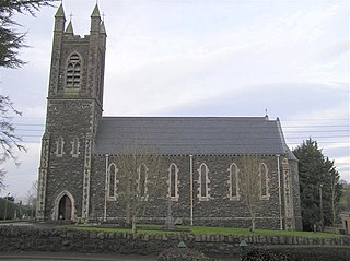
Draperstown is a village in the Sperrin Mountains in County Londonderry, Northern Ireland. It is situated in the civil parish of Ballinascreen and is part of Mid-Ulster district. It is also part of the Church of Ireland parish of Ballynascreen and the Catholic parish of Ballinascreen, and within the former barony of Loughinsholin.
Newbuildings or New Buildings is a large village in County Londonderry, Northern Ireland. It lies close to the banks of the River Foyle and 3 mi (5 km) south of the city of Derry. It had a population of 3,381 in the 2011 Census. It is within Derry and Strabane district.

Ballymagorry or Ballymagory is a small village and townland in County Tyrone, Northern Ireland. It is west of Artigarvan and 5 kilometres (3.1 mi) north of Strabane. In the 2001 Census it had a population of 565. It lies within the Strabane District Council area and lies on the River Glenmornan.

Feeny is a village and townland in County Londonderry, Northern Ireland. It is between Dungiven and Claudy. In the 2011 Census it had a population of 690. Feeny lies just inside the boundary of the Sperrins Area of Outstanding Natural Beauty. It is situated within Causeway Coast and Glens district.

Greysteel or Gresteel is a village in County Londonderry, Northern Ireland. It lies 9 miles (14 km) to the east of Derry and 7 miles (11 km) to the west of Limavady on the main A2 coast road between Limavady and Derry, overlooking Lough Foyle. It is designated as a Large Village and in the 2001 Census it had a population of 1,229 people, an increase of almost 20% compared to 1991. It is situated within Causeway Coast and Glens district.
Goshedan is a hamlet and townland in County Londonderry, Northern Ireland. In the 2001 Census it had a population of 90 people. It is situated within the Derry and Strabane district.
Killaloo is a townland and hamlet in County Londonderry, Northern Ireland. It is about six miles southeast of Derry, on the main Derry to Belfast road. In the 2001 census, Killaloo had a population of 75 people. It is situated within Derry and Strabane district.

Lower Ballinderry is a small village to the west of Upper Ballinderry in County Antrim, Northern Ireland. It is within the townland and civil parish of Ballinderry and the historic barony of Massereene Upper. The village lies a short distance to the southeast of Portmore Lough and Lough Neagh, 12 kilometres (7.5 mi) west of Lisburn. In the 2011 census it had a population of 912.

Clady is a small village and townland in County Tyrone, Northern Ireland. It lies about 4 miles from Strabane on the River Finn and borders the Republic of Ireland. In the 2011 Census it had a population of 538 people. It is within Urney civil parish and the former barony of Strabane Lower. In local government it is part of the Derry City and Strabane District Council. The townland covers an area of 173 acres.
Magheramason is a small village and townland in County Tyrone, Northern Ireland. The village sits near the County Londonderry/County Tyrone border, 5 miles (8.0 km) from the city of Derry and 9 miles (14 km) from the town of Strabane. In the 2001 census, it had a population of 393 people. It lies within the Derry City and Strabane District Council area.
Ballinderry is a small civil and ecclesiastical parish on both sides of the County Londonderry / County Tyrone border in Northern Ireland. It is a rural parish of about 350 houses and lies on the western shores of Lough Neagh.
The Loup is a small village in County Londonderry, Northern Ireland. It lies near the western shore of Lough Neagh between Moneymore, Magherafelt, Ballyronan and Coagh, within the district of Mid Ulster.

Ballerin is a small village between Garvagh and Ringsend in County Londonderry, Northern Ireland. It is located within Causeway Coast and Glens district. It includes Saint Columba's Catholic primary school and Saint Mary's Catholic church.
Elagh More is a townland in County Londonderry, Northern Ireland and lies between Ballynagalliagh and the border with County Donegal in the Republic of Ireland, on the outskirts of Derry. It is within Derry City and Strabane district.

Altnagelvin is a townland in County Londonderry, Northern Ireland. It is also the name of an electoral ward in Derry and Strabane district. Formerly a small village, it has been absorbed into the Waterside neighbourhood of Derry. Within Altnagelvin is Altnagelvin Area Hospital, a large hospital which serves most of the county.

The A515 Skeoge Link is a road in Northern Ireland which was designed to complete the route between Foyle Bridge in County Londonderry and County Donegal. It is part of a larger project to link County Donegal with Belfast. The total construction cost was £5 million.
Shanvey is a small village and townland in County Londonderry, Northern Ireland. It lies about 6 kilometres (3.7 mi) north of Limavady on Aghanloo Road, the A2 coastal route between Limavady and Coleraine. It is designated as a hamlet and is situated within Causeway Coast and Glens district and in the former North Londonderry Area of Outstanding Natural Beauty, now redesignated as the Binevenagh Area of Outstanding Natural Beauty (AONB).
Tirkeeran is a barony in County Londonderry, Northern Ireland. It connects to the north-Londonderry coastline, and is bordered by four other baronies: Keenaght to the east; Strabane Lower to the south-east; North West Liberties of Londonderry to the west; and Strabane Upper to the south.

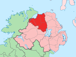
Derry City and Strabane is a local government district that was created on 1 April 2015 by merging the City of Derry District and Strabane District. It covers most of the northwest of Northern Ireland. The local authority is Derry City and Strabane District Council.

