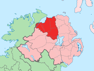
County Londonderry, also known as County Derry, is one of the six counties of Northern Ireland, one of the thirty-two counties of Ireland and one of the nine counties of Ulster. Before the partition of Ireland, it was one of the counties of the Kingdom of Ireland from 1613 onward and then of the United Kingdom after the Acts of Union 1800. Adjoining the north-west shore of Lough Neagh, the county covers an area of 2,118 km2 (818 sq mi) and today has a population of about 252,231.

Newcastle is a small seaside resort town in County Down, Northern Ireland, which had a population of 8,298 at the 2021 Census. It lies by the Irish Sea at the foot of Slieve Donard, the highest of the Mourne Mountains. Newcastle is known for its sandy beach, forests, and mountains. The town lies within the Newry, Mourne and Down District.
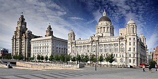
Merseyside is a ceremonial and metropolitan county in North West England. It borders Lancashire to the north, Greater Manchester to the east, Cheshire to the south, the Welsh county of Flintshire across the Dee Estuary to the southwest, and the Irish Sea to the west. The largest settlement is the city of Liverpool.

Tralee is the county town of County Kerry in the south-west of Ireland. The town is on the northern side of the neck of the Dingle Peninsula, and is the largest town in County Kerry. The town's population was 26,079 as of the 2022 census, making it the 15th largest urban settlement in Ireland. Tralee is known for the Rose of Tralee International Festival, which has been held annually in August since 1959.

Mallow is a town in County Cork, Ireland, approximately thirty-five kilometres north of Cork. Mallow is in a townland and civil parish of the same name, in the barony of Fermoy.
Ballinhassig is a village in County Cork, Ireland, situated 10.6 km (6.6 mi) south of Cork City just off the N71 Bandon road and near the source of the River Owenabue.

Sport in Ireland plays an important role in Irish society. The many sports played and followed in Ireland include Gaelic games, association football, horse racing, show jumping, greyhound racing, basketball, fishing, motorsport, boxing, tennis, hockey, golf, rowing, cricket, and rugby union.

Ballintra is a village in the parish of Drumholm in the south of County Donegal, Ireland, just off the N15 road between Donegal town and Ballyshannon. Ballintra lies on the northern bank of the Blackwater river. The river rises in the hills that lie inland from the town, and flows through a number of small lakes before spilling over a small waterfall in a gorge behind the village.

Dunboyne is a town in County Meath, Ireland, 15 km (9 mi) north-west of Dublin city centre. It is a commuter town for Dublin. In the 20 years between the 1996 and 2016 censuses, the population of Dunboyne more than doubled from 3,080 to 7,272 inhabitants. As per the 2022 census, the population decreased slightly to 7,155. The town is in a townland and civil parish of the same name.

The Ballymena Showgrounds is a football stadium in Ballymena, County Antrim, Northern Ireland. It is home to Ballymena United F.C. and Ballymena United Women F.C. It is owned by Mid and East Antrim Borough Council. In addition to men's football a variety of other sports and events are held at the stadium and surrounding facilities, including women's association football, field hockey, and, formerly, stock car racing.

Aughnacloy, sometimes spelt Auchnacloy, is a village in County Tyrone, Northern Ireland. Close to the border with County Monaghan in the Republic of Ireland, the village is about 20 km southwest of Dungannon, and 7 km southeast of Ballygawley. It is situated in the historic barony of Dungannon Lower and the civil parish of Carnteel. In the 2011 census it had a population of 1,045.
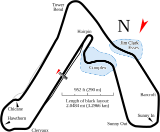
Croft Circuit is a motor racing circuit located near Dalton-on-Tees in North Yorkshire, England. The tarmac circuit is 2.127 mi (3.423 km) long and is based on the lands of an airfield, but has long since moved on from being a basic airfield circuit. The circuit holds meetings of the British Touring Car Championship, British Rallycross and Pickup Truck Racing race series.

Laytown is a village in County Meath, Ireland, located on the R150 regional road and overlooking the Irish Sea. Historically it was called Ninch, after the townland it occupies. Together with the neighbouring villages of Mornington, Bettystown and Donacarney, it comprises the census town of Laytown–Bettystown–Mornington–Donacarney, which recorded a population of 15,642 in the 2022 census.

Cappoquin, also sometimes spelt Cappaquin, is a town in western County Waterford, Ireland. It is on the Blackwater river at the junction of the N72 national secondary road and the R669 regional road. It is positioned on a sharp 90-degree bend in the river and lies at the foot of the Knockmealdown Mountains. The town is a few miles from Mount Melleray and Lismore, County Waterford.

Kilrea is a village, townland and civil parish in County Londonderry, Northern Ireland. It gets its name from the ancient church that was located near where the current Church of Ireland is located on Church Street looking over the town. It is near the River Bann, which marks the boundary between County Londonderry and County Antrim. In the 2011 Census it had a population of 1,678 people. It is situated within Causeway Coast and Glens district.

Caragh or Carragh is a village in County Kildare, Ireland. It is located on the R409 regional road between the River Liffey and the Grand Canal and is located 6.1 km north-west of Naas. The village is also 7.9 km from Clane and 10.6 km from Newbridge.

Rossnowlagh is a seaside village in the south of County Donegal, Ireland. It is about 8 kilometres (5 mi) north of Ballyshannon and 16 km (10 mi) southwest of Donegal Town. The area's 3 km (2 mi) long beach, or 2 km (1.2 mi) if measuring from the cliffs to Carrickfad, is frequented by walkers, surfers, windsurfers, kite-surfers and swimmers.

Leixlip is a town in north-east County Kildare, Ireland. Its location on the confluence of the River Liffey and the Rye Water has marked it as a frontier town historically: on the border between the ancient kingdoms of Leinster and Brega, as an outpost of The Pale, and on Kildare's border with County Dublin. Leixlip was also a civil parish in the ancient barony of Salt North.

Killygordon is a small village in the Finn Valley in the east of County Donegal, Ireland. As of 2022, the population was 716. It is located on the N15 between Stranorlar and Castlefin. The separate hamlet and townland of Crossroads, usually known as The Cross, lies half a mile from Killygordon. The River Finn passes by the village on its way towards its confluence with the River Mourne and the River Foyle.

The Agivey River is a medium to large river in County Londonderry. It starts at the confluence of the Ashlamaduff and Formill Rivers up in The Sperrin Mountains in Glenullin and flows through said area and flows onwards Eastward direction towards Garvagh.The river flows through Errigal Glen a massive gorge on the river with a 20-meter drop from the top to the river, Errigal Bridge at the start of the glen is said to be one the oldest bridges in Ireland. The river flows through Garvagh over the famous horseshoe weir onwards north towards aghadowey then turns east again. It passes Hunters mill and under the Bovagh Bridge. It flows through Bovagh house estate which is now a b&b. The river flows for the last few miles north passing Cullycapple Bridge and Brickhill Bridge passes the Brown Trout inn and joins with the Aghadowey River then flows eastwards for a final time under Glasgort Bridge then into the River Bann. It joins the River Bann near Ballymoney. It is one of NI Game Angling Rivers it has its own angling association called The Agivey Angling Association Methods of fishing include Fly, Spinning And Worming, It boasts a healthy stock of fish including Salmon and Brown Trout.


