
Bushmills is a village on the north coast of County Antrim, Northern Ireland. Bushmills had a population of 1,247 in the 2021 Census. It is located 60 miles (97 km) from Belfast, 11 miles (18 km) from Ballycastle and 9 miles (14 km) from Coleraine. The village owes its name to the River Bush and to a large watermill that was built there in the early 17th century. It is home to the Old Bushmills Distillery, which produces Irish whiskey, and is near the Giant's Causeway.

Castlederg is a town in County Tyrone, Northern Ireland. It lies on the River Derg and is near the border with County Donegal, Ireland. It stands in the townlands of Castlesessagh and Churchtown, in the historic barony of Omagh West and the civil parish of Urney. The village has a ruined castle and two ancient tombs known as the Druid's Altar and Todd's Den. It had a population of 2,980 people at the 2021 Census.

Kircubbin is a village and townland in County Down, Northern Ireland. The village had a population of 1,153 people in the 2011 Census.

Tandragee is a town in County Armagh, Northern Ireland. It is built on a hillside overlooking the Cusher River, in the civil parish of Ballymore and the historic barony of Orior Lower.

Crossgar is a village and townland in County Down, Northern Ireland. It is about 15 miles (24 km) south of Belfast – between Saintfield and Downpatrick. Crossgar had a population 1,892 people in the 2011 UK Census.
Templepatrick is a village and civil parish in County Antrim, Northern Ireland. It is 9.2 miles (14.8 km) northwest of Belfast, and halfway between the towns of Ballyclare and Antrim. It is also close to Belfast International Airport and the village has several hotels. Templepatrick is the site of historic Church of Ireland, Presbyterian and the Old Presbyterian Church. It had a population of 1,437 people in the 2011 Census.
Parkgate is a small village in County Antrim, Northern Ireland. It lies at the foot of Donegore Hill, near the Six Mile Water. It is about midway between Ballyclare and Antrim town. It lies within the Borough of Antrim. It had a population of 676 people in the 2011 Census.

Millisle or Mill Isle is a village on the Ards Peninsula in County Down, Northern Ireland. It is about 3 miles (4.8 km) south of Donaghadee. It is situated in the townlands of Ballymacruise and Ballycopeland, the civil parish of Donaghadee and the historic barony of Ards Lower. It had a population of 2,318 people in the 2011 Census.

Annsborough is a small village in County Down which is one of the main residential areas in Castlewellan, Northern Ireland. It is situated on the A25 road between Downpatrick and Newry, about 0.8 kilometres to the east of Castlewellan and 17 kilometres to the south west of Downpatrick. It had a population of 593 in the 2001 Census. The village is situated within the Mourne Area of Outstanding Natural Beauty.

Ballywalter is a village or townland and civil parish in County Down, Northern Ireland. It is on the east coast of the Ards Peninsula between Donaghadee and Ballyhalbert. Ballywalter was formerly known as Whitkirk as far back as the 12th century. It had a population of 2,027 people in the 2011 census.
Balnamore is a small village in County Antrim, Northern Ireland. It is within the townland of Ballynacree-Skein and lies 3 km west of Ballymoney. It is part Causeway Coast and Glens District Council. Historically it was known as Ballinamore.

Carrowdore is a small village on the Ards Peninsula in County Down, Northern Ireland. It is situated in the townland of Ballyrawer, the civil parish of Donaghadee and the historic barony of Ards Lower. It lies within the Ards and North Down Borough. It had a population of 960 people in the 2011 Census.

Cloghy, also spelt Cloughey or Cloughy, is a small village and townland in County Down, Northern Ireland. It lies on the east coast of the Ards Peninsula, in the Ards and North Down Borough. It had a population of 1,075 people in the 2011 Census.

Greysteel or Gresteel is a village in County Londonderry, Northern Ireland. It lies 9 miles (14 km) to the east of Derry and 7 miles (11 km) to the west of Limavady on the main A2 coast road between Limavady and Derry, overlooking Lough Foyle. It is designated as a Large Village and in the 2001 Census it had a population of 1,229 people, an increase of almost 20% compared to 1991. It is situated within Causeway Coast and Glens district.
Macosquin is a small village, townland, and civil parish in County Londonderry, Northern Ireland. It is 4 kilometres (2.5 mi) south-west of Coleraine, on the road to Limavady. In the 2011 Census it had a population of 614 people. The area is known for its caves and springs. It is situated within Causeway Coast and Glens district.
Richhill is a large village and townland in County Armagh, Northern Ireland. It lies between Armagh and Portadown. It had a population of 2,738 people in the 2021 Census.

Tempo, historically called Tempodeshel, is a small village at the foot of Brougher Mountain in County Fermanagh, Northern Ireland. The Census of 2011 recorded a population of 489 people. It lies within the Fermanagh and Omagh District Council area.

Waringstown is a large village in County Down, Northern Ireland. It lies southeast of Lurgan, within the parish of Donaghcloney, and the barony of Iveagh Lower, Lower Half. In the 2011 Census it had a population of 3,683 people. Over the years, the village has been bestowed numerous awards, including "Best Kept Small Town" for its floral displays and pleasant appearance.
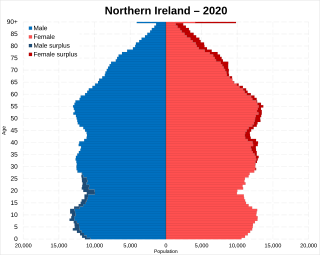
Northern Ireland is the smallest of the four components of the United Kingdom in terms of both area and population, containing 2.9% of the total population and 5.7% of the total area of the United Kingdom. It is the smaller of the two political entities on the island of Ireland by area and population, the other being the Republic of Ireland. Northern Ireland contains 27.1% of the total population and 16.75% of the total area of the island of Ireland.


