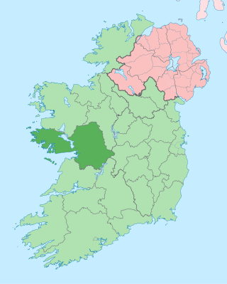
County Galway is a county in Ireland. It is in the Northern and Western Region, taking up the south of the province of Connacht. The county population was 276,451 at the 2022 census.

Castlereagh was a local government district with the status of borough in Northern Ireland. It merged with Lisburn City Council in May 2015 under local government reorganisation in Northern Ireland to become Lisburn and Castlereagh City Council, with a small amount being transferred to Belfast City Council.

Portstewart is a small town in County Londonderry, Northern Ireland. It had a population of 8,003 people in the 2011 Census. It is a seaside resort neighbouring Portrush. Its harbour and scenic coastal paths form an Atlantic promenade leading to a two-miles beach, popular with holidaymakers in summer and surfers year-round.

Castlederg is a town in County Tyrone, Northern Ireland. It lies on the River Derg and is near the border with County Donegal, Ireland. It stands in the townlands of Castlesessagh and Churchtown, in the historic barony of Omagh West and the civil parish of Urney. The village has a ruined castle and two ancient tombs known as the Druid's Altar and Todd's Den. It had a population of 2,976 people at the 2011 Census.

Belfast City Council is the local authority with responsibility for part of the city of Belfast, the capital and largest city of Northern Ireland. The council serves an estimated population of 341,877 (2019), the largest of any district council in Northern Ireland, while being the smallest by area. Belfast City Council is the primary council of the Belfast Metropolitan Area, a grouping of six former district councils with commuter towns and overspill from Belfast, containing a total population of 579,276.

Etobicoke North is a federal electoral district in Toronto, Ontario, Canada, that has been represented by one Member of Parliament in the House of Commons of Canada since 1979. It covers the neighbourhood of Rexdale, in the northern part of the Etobicoke district of Toronto.

Mayobridge is a village within Newry, County Down, Northern Ireland, lying on the small river Clanrye which divides the townlands of Mayo and Bavan. It is located within the Newry and Mourne District Council area - it had a population of 1,069 people in the 2011 Census. It falls within the parish of Clonallan, and historically within the barony of Upper Iveagh Upper.
The demographics of Toronto, Ontario, Canada make Toronto one of the most multicultural and multiracial cities in the world. In 2021, 57.0 percent of the residents of the metropolitan area belonged to a visible minority group, compared with 51.4 percent in 2016, and 13.6 percent in 1981. Toronto also has established ethnic neighbourhoods such as the multiple Chinatowns, Corso Italia, Little Italy, Little India, Greektown, Koreatown, Little Jamaica, Little Portugal and Roncesvalles, which celebrate the city's multiculturalism. Data from the suburban municipalities are also included for some metrics as most of these municipalities are part of the Toronto CMA.
An electoral division is a legally defined administrative area in the Republic of Ireland, generally comprising multiple townlands, and formerly a subdivision of urban and rural districts. Until 1996, EDs were known as district electoral divisions in the 29 county council areas and wards in the five county boroughs. Until 1972, DEDs also existed in Northern Ireland. The predecessor poor law electoral divisions were introduced throughout the island of Ireland in the 1830s. The divisions were used as local-government electoral areas until 1919 in what is now the Republic and until 1972 in Northern Ireland.

Douglas Bridge is a small village near Strabane in County Tyrone, Northern Ireland. In the 2011 Census it had a population of 124. It lies within the Derry City and Strabane area.
The wards and electoral divisions in the United Kingdom are electoral districts at sub-national level, represented by one or more councillors. The ward is the primary unit of English electoral geography for civil parishes and borough and district councils, the electoral ward is the unit used by Welsh principal councils, while the electoral division is the unit used by English county councils and some unitary authorities. Each ward/division has an average electorate of about 5,500 people, but ward population counts can vary substantially. As of 2021 there are 8,694 electoral wards/divisions in the UK.
Jordanstown is a townland and electoral ward in County Antrim, Northern Ireland. It is within the urban area of Newtownabbey and the Antrim and Newtownabbey Borough Council area. It is also situated in the civil parish of Carnmoney and the historic barony of Belfast Lower. It had a population of 6,225 in the 2011 census, with an average age of 40.

Goresbridge is a small village located in the east of County Kilkenny, in the province of Leinster, Ireland. Goresbridge is named after a 1756 bridge, built by Colonel Ralph Gore, which provides a crossing of the River Barrow between County Kilkenny and County Carlow in the South-East region.

Banbridge is a town in County Down, Northern Ireland. It lies on the River Bann and the A1 road and is named after a bridge built over the River Bann in 1712. It is situated in the civil parish of Seapatrick and the historic barony of Iveagh Upper, Upper Half. The town began as a coaching stop on the road from Belfast to Dublin and thrived from Irish linen manufacturing. The town was home to the headquarters of the former Banbridge District Council. Following a reform of local government in Northern Ireland in 2015, Banbridge became part of Armagh City, Banbridge and Craigavon Borough Council. It had a population of 16,637 in the 2011 Census.

Altnagelvin is a townland in County Londonderry, Northern Ireland. It is also the name of an electoral ward in Derry and Strabane district. Formerly a small village, it has been absorbed into the Waterside neighbourhood of Derry. Within Altnagelvin is Altnagelvin Area Hospital, a large hospital which serves the most of the county.

A census of the population of the United Kingdom is taken every ten years. The 2011 census was held in all countries of the UK on 27 March 2011. It was the first UK census which could be completed online via the Internet. The Office for National Statistics (ONS) is responsible for the census in England and Wales, the General Register Office for Scotland (GROS) is responsible for the census in Scotland, and the Northern Ireland Statistics and Research Agency (NISRA) is responsible for the census in Northern Ireland.

Carrick is a village located within the civil parish of Glencolmcille in County Donegal, Ireland. As of the 2016 census, the population of the village was 265. Carrick is located between neighbouring towns Glencolmcille, Meenanary, Teelin and Kilcar. Nearby is Sliabh Liag, the highest sea cliff in Europe.

Ladysbridge, known for census purposes as Knockglass, is a village in County Cork, Ireland. As of the 2016 census, the area had a population of 658 people.
Bridebridge is a village in County Cork, Ireland, just south of Castlelyons. The village is named for the stone bridge across the River Bride, at the south end of the village. The population was 187 at the 2016 census. The local soccer club is Castlebridge Celtic.


