
Derry, officially Londonderry, is the second-largest city in Northern Ireland and the fifth-largest city on the island of Ireland. The old walled city lies on the west bank of the River Foyle, which is spanned by two road bridges and one footbridge. The city now covers both banks.
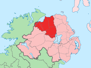
County Londonderry, also known as County Derry, is one of the six counties of Northern Ireland, one of the thirty two counties of Ireland and one of the nine counties of Ulster. Before the partition of Ireland, it was one of the counties of the Kingdom of Ireland from 1613 onward and then of the United Kingdom after the Acts of Union 1800. Adjoining the north-west shore of Lough Neagh, the county covers an area of 2,118 km2 (818 sq mi) and today has a population of about 252,231.

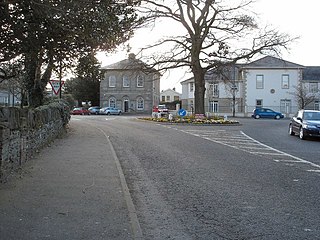
Limavady is a market town in County Londonderry, Northern Ireland, with Binevenagh as a backdrop. Lying 17 miles (27 km) east of Derry and 14 miles (23 km) southwest of Coleraine, Limavady had a population of 11,279 people at the 2021 Census. In the 40 years between 1971 and 2011, Limavady's population nearly doubled. Limavady is within Causeway Coast and Glens Borough.

City of Derry Airport, previously known as RAF Eglinton and Londonderry Eglinton Airport, is a regional airport located 7 mi (11 km) northeast of Derry, Northern Ireland. It is located on the south bank of Lough Foyle, a short distance from the village of Eglinton and 8 mi (13 km) from the city centre.

Royal Air Force North Witham or more simply RAF North Witham is a former Royal Air Force station located in Twyford Wood, off the A1 between Stamford and Grantham, Lincolnshire, England about 104 miles (167 km) north-northwest of London.

Ballykelly is a village and townland in County Londonderry, Northern Ireland. It lies 3 miles (4.8 km) west of Limavady on the main Derry to Limavady A2 road and is 15 miles (24 km) east of Derry. It is designated as a Large Village and in 2011 the population of Ballykelly was 2,107. It lies within Causeway Coast and Glens district.
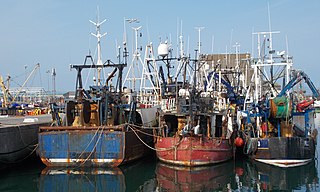
Portavogie is a village, townland and fishing port in County Down, Northern Ireland. It lies within the Ards and North Down Borough and is the easternmost settlement in Ireland. It had a population of 2,122 people in the 2011 Census.
Eglinton is a village in County Londonderry, Northern Ireland. It lies 5.5 miles (8.9 km) east-north-east of Derry, to which it serves as a sleeper village, and 9.5 miles (15.3 km) west-south-west of Limavady. It resides within Derry and Strabane district. The City of Derry Airport, also known as Eglinton Aerodrome and formerly as Londonderry Eglinton Airport, lies a short distance from the village.

Ballyhalbert is a small village and townland in County Down, Northern Ireland. It is on the east coast of the Ards Peninsula between Ballywalter and Portavogie. It is largely residential and has a small harbour and large caravan site which was formerly a Royal Air Force (RAF) airfield, RAF Ballyhalbert, during World War II. It is within the Ards and North Down Borough. It had a population of 1,026 people in the 2011 Census, up from 447 people in the 2001 Census.
Strathfoyle is a village in County Londonderry, Northern Ireland It is about 5 miles (8.0 km) north east of Derry. It was newly built in different phases between the late 1950s and the early 1960s, with many new recent additions to the village, including Westlake, Butler's Wharf and Old Fort. In the 2001 Census it had a population of 1,581 people. It is within the Derry Urban Area and the Derry City Council area. The village has a small retail outlet, a Roman Catholic chapel, a library, youth club and a post office. The small retail unit was constructed in 2005 following years of under-investment in the area and pressure by local community leaders to provide more facilities for its residents.

Killadeas is a small village in County Fermanagh, Northern Ireland. It is about 7 miles north of Enniskillen near the shores of Lower Lough Erne, and is within Fermanagh and Omagh district. In the 2001 Census it had a population of 90 people.

The DuPont Experimental Station is the largest research and development facility of DuPont, located on the banks of the Brandywine Creek in Wilmington, Delaware
Bellarena is a small village and townland in County Londonderry, Northern Ireland. It is on the A2 coastal road between Limavady and Coleraine, 6 miles (9.7 km) north of Limavady. The land was settled in the mid-17th century by a Northamptonshire gentleman, William Gage, who bought the lease of the estate – then called Ballymargy from the Irish meaning "town of the market" – from the Lord Bishop of Derry. In the 2001 census the population was 291. The village lies within Causeway Coast and Glens District Council area and the Binevenagh Area of Outstanding Natural Beauty, with open views eastwards to the scarp slope of Binevenagh. The village gets its name from the Earl Bishop of Derry.

Enagh Lough is a pair of lakes called East lake and Westlake, situated between Judges Road and Temple Road in Maydown, County Londonderry, Northern Ireland.

Royal Air Force Bottesford or more simply RAF Bottesford is a former Royal Air Force station located on the Leicestershire-Lincolnshire county border, 6.8 miles (10.9 km) north west of Grantham, Lincolnshire and 7.6 miles (12.2 km) south of Newark-on-Trent, Nottinghamshire and about 107 miles (172 km) north-northwest of London, England.
Jeffery Stanford Agate, OBE was the Managing Director of the DuPont factory at Maydown, County Londonderry, Northern Ireland. He was shot dead by members of the Provisional Irish Republican Army (IRA) outside his home at Talbot Park, Derry as he returned from work on the evening of 2 February 1977.
Royal Air Force Limavady or more simply RAF Limavady is a former Royal Air Force station, also known as Aghanloo airfield, near the city of Derry, Northern Ireland.
DuPont de Nemours, Inc., commonly shortened to DuPont, is an American multinational chemical company first formed in 1802 by French-American chemist and industrialist Éleuthère Irénée du Pont de Nemours. The company played a major role in the development of Delaware and first arose as a major supplier of gunpowder. DuPont developed many polymers such as Vespel, neoprene, nylon, Corian, Teflon, Mylar, Kapton, Kevlar, Zemdrain, M5 fiber, Nomex, Tyvek, Sorona, Corfam and Lycra in the 20th century, and its scientists developed many chemicals, most notably Freon (chlorofluorocarbons), for the refrigerant industry. It also developed synthetic pigments and paints including ChromaFlair.
Royal Naval Air Station Maydown or RNAS Maydown (HMS Shrike) is a former Fleet Air Arm base located 4.3 miles (6.9 km) northeast of Derry, County Londonderry and 11.4 miles (18.3 km) west of Limavady, County Londonderry, Northern Ireland.


