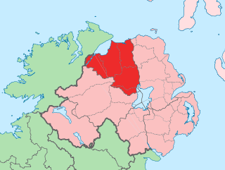
County Londonderry, also known as County Derry, is one of the six counties of Northern Ireland, one of the thirty-two counties of Ireland and one of the nine counties of Ulster. Before the partition of Ireland, it was one of the counties of the Kingdom of Ireland from 1613 onward and then of the United Kingdom after the Acts of Union 1800. Adjoining the north-west shore of Lough Neagh, the county covers an area of 2,118 km2 (818 sq mi) and today has a population of about 252,231.

Limavady is a market town in County Londonderry, Northern Ireland, with Binevenagh as a backdrop. Lying 17 miles (27 km) east of Derry and 14 miles (23 km) southwest of Coleraine, Limavady had a population of 11,279 people at the 2021 Census. In the 40 years between 1971 and 2011, Limavady's population nearly doubled. Limavady is within Causeway Coast and Glens Borough.

Magilligan is a peninsula that lies in the northwest of County Londonderry, Northern Ireland, at the entrance to Lough Foyle, within Causeway Coast and Glens district. It is an extensive 79,000-acre (32,000-hectare) coastal site, part British army firing range, part nature reserve and is home to the HM Prison Magilligan. The settlement of Magilligan Point on the lough is noted for its ferry crossing to Greencastle, County Donegal. The peninsula contains a civil parish of the same name.

Lough Foyle, sometimes Loch Foyle, is the estuary of the River Foyle, on the north coast of Ireland. It lies between County Londonderry in Northern Ireland and County Donegal in the Republic of Ireland. Sovereignty over the waters has been in dispute since the Partition of Ireland.

Binevenagh is a large, steep-sided hill in County Londonderry, Northern Ireland. It is part of the Keenaght Hills, which mark the western edge of the Antrim Plateau, formed around 60 million years ago by molten lava. Binevenagh and its cliffs overlook the Magilligan peninsula and dominate the skyline over the villages of Bellarena, Downhill, Castlerock and Benone beach. The area has been classified as both an Area of Special Scientific Interest and as an Area of Outstanding Natural Beauty (AONB). The total area of the AONB is 138 km2.

Ballykelly is a village and townland in County Londonderry, Northern Ireland. It lies 3 miles (4.8 km) west of Limavady on the main Derry to Limavady A2 road and is 15 miles (24 km) east of Derry. It is designated as a Large Village and in 2011 the population of Ballykelly was 2,107. It lies within Causeway Coast and Glens district.

Castlerock is a seaside village in County Londonderry, Northern Ireland. It is five miles west of Coleraine, and part of Causeway Coast and Glens district. It is very popular with summer tourists, with numerous apartment blocks and two caravan sites. Castlerock Golf Club has both 9-hole and 18-hole links courses bounded by the beach, the River Bann and the Belfast to Derry railway line. The village had a population of 1,155 people at the 2021 census, and is where near by village Articlave F.C play their home games.
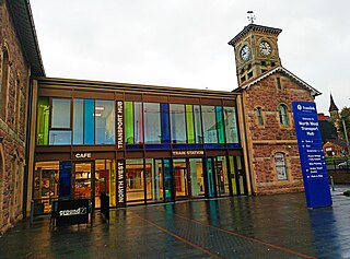
Derry ~ Londonderry railway station, also known as North West Transport Hub or Waterside railway station, is a railway terminus in Derry, Northern Ireland, on the east bank of the River Foyle, operated by Northern Ireland Railways and its 7th busiest station across the network with 952,126 passengers boarding or alighting at the station in the 2023/24 financial year. It is on the Belfast–Derry railway line, terminating at Belfast Grand Central. Derry/Londonderry has the longest platforms on the NIR Network, at 258.3 metres in length.

Burnfoot is a small village within the townland of Bonnanaboigh in County Londonderry, Northern Ireland.

The Belfast–Derry line is an intercity railway line, running from Belfast to Derry in Northern Ireland.

Ardmore is a village and townland in County Londonderry, Northern Ireland. In the 2001 Census it had a population of 210. It is within Derry and Strabane district. Ardmore has a number of sports teams including cricket, soccer and Gaelic football.

Bellarena railway station serves the village of Bellarena and the broader Limavady area in County Londonderry, Northern Ireland. The current two-platform station was opened in 2016, replacing the original single-platform 1853 station located on the opposite side of the nearby level crossing.

Castlerock railway station serves the villages of Castlerock, Articlave and their surrounding hamlets in County Londonderry, Northern Ireland. Walkers use the station to reach Mussenden Temple, Downhill Strand and Benone.

Benone is a popular tourist destination in the Causeway Coast and Glens district, County Londonderry, Northern Ireland.
Shanvey is a small village and townland in County Londonderry, Northern Ireland. It lies about 6 kilometres (3.7 mi) north of Limavady on Aghanloo Road, the A2 coastal route between Limavady and Coleraine. It is designated as a hamlet and is situated within Causeway Coast and Glens district and in the former North Londonderry Area of Outstanding Natural Beauty, now redesignated as the Binevenagh Area of Outstanding Natural Beauty (AONB).

Causeway Coast and Glens is a local government district covering most of the northern part of Northern Ireland. It was created on 1 April 2015 by merging the Borough of Ballymoney, the Borough of Coleraine, the Borough of Limavady and the District of Moyle. The local authority is Causeway Coast and Glens Borough Council.
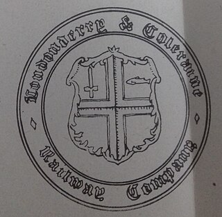
The Londonderry & Coleraine Railway is a railway line between the cities of Derry and Coleraine in County Londonderry, built by the Londonderry & Coleraine Railway Company (L&CR). The company operated the line independently for seven years before being absorbed into the Belfast & Northern Counties Railway. The line is still in use today by NI Railways and forms part of the Belfast to Derry-Londonderry rail line.


