Killaloo

Last updated

Killaloo
hamlet, townland
United Kingdom adm location map.svg
Red pog.svg
Coordinates: 54°55′N7°11′W / 54.917°N 7.183°W / 54.917; -7.183
Cumber Church of Ireland, Killaloo Cumber Church of Ireland - geograph.org.uk - 415655.jpg
Cumber Church of Ireland, Killaloo
The Presbyterian church Newcumber Presbyterian Church - geograph.org.uk - 415649.jpg
The Presbyterian church

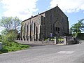
Killaloo (from Irish Coill a' Lao, meaning 'wood of the calf' or Cill Dhalua meaning "Dalua's church") [1] [2] is a townland and hamlet in County Londonderry, Northern Ireland. It is about six miles southeast of Derry, on the main Derry to Belfast road. In the 2001 census, Killaloo had a population of 75 people. It is situated within Derry and Strabane district.

Contents

The nearest shops and amenities are in the village of Claudy, to the southeast.

Places of interest

The ruins of Brackfield Bawn are beside the main road. The Ness Woods country park is also in the area.[ citation needed ]

Related Research Articles

<span class="mw-page-title-main">Omagh</span> County town of County Tyrone, Northern Ireland

Omagh is the county town of County Tyrone, Northern Ireland. It is situated where the rivers Drumragh and Camowen meet to form the Strule. Northern Ireland's capital city, Belfast, is 68 miles (109.5 km) to the east of Omagh, and Derry is 34 miles (55 km) to the north.

<span class="mw-page-title-main">Draperstown</span> Village in County Londonderry, Northern Ireland

Draperstown is a village in the Sperrin Mountains in County Londonderry, Northern Ireland. It is situated in the civil parish of Ballinascreen and is part of Mid-Ulster district. It is also part of the Church of Ireland parish of Ballynascreen and the Catholic parish of Ballinascreen, and within the former barony of Loughinsholin.

<span class="mw-page-title-main">Swatragh</span> Village in County Londonderry, Northern Ireland

Swatragh is a small village and townland in County Londonderry, Northern Ireland. Swatragh is on the main A29 road north of Maghera, and is situated within Mid-Ulster District. The population was 438 in the 2011 Census. The village has three churches: one Roman Catholic, one Church of Ireland, and one Presbyterian. The Catholic and Church of Ireland churches are listed buildings. St John's is the local primary school.

Landahaussy or Landahussy is a small village and townland near Plumbridge in County Tyrone, Northern Ireland. It is within the Derry City and Strabane District Council area.

<span class="mw-page-title-main">Newbuildings</span> Village in County Londonderry, Northern Ireland

Newbuildings or New Buildings is a large village in County Londonderry, Northern Ireland. It lies close to the banks of the River Foyle and 3 mi (5 km) south of the city of Derry. It had a population of 3,381 in the 2011 Census. It is within Derry and Strabane district.

Ballynagalliagh is a townland in County Londonderry, Northern Ireland. It lies within Derry and Strabane district.

<span class="mw-page-title-main">Claudy</span> Village in County Londonderry, Northern Ireland

Claudy is a village and townland in County Londonderry, Northern Ireland. It lies in the Faughan Valley, 6 miles (9.7 km) southeast of Derry, where the River Glenrandal joins the River Faughan. It is situated in the civil parish of Cumber Upper and the historic barony of Tirkeeran. It is also part of Derry and Strabane district.

<span class="mw-page-title-main">Feeny</span> Village in County Londonderry, Northern Ireland

Feeny is a village and townland in County Londonderry, Northern Ireland. It is between Dungiven and Claudy. In the 2011 Census it had a population of 690. Feeny lies just inside the boundary of the Sperrins Area of Outstanding Natural Beauty. It is situated within Causeway Coast and Glens district.

<span class="mw-page-title-main">Garvagh</span> Village in County Londonderry, Northern Ireland

Garvagh is a village in County Londonderry, Northern Ireland. It is on the banks of the Agivey River, 18 kilometres (11 mi) south of Coleraine on the A29 route. In the 2001 Census it had a population of 1,288. It is situated within Causeway Coast and Glens district.

<span class="mw-page-title-main">Greysteel</span> Village in County Londonderry, Northern Ireland

Greysteel or Gresteel is a village in County Londonderry, Northern Ireland. It lies 9 miles (14 km) to the east of Derry and 7 miles (11 km) to the west of Limavady on the main A2 coast road between Limavady and Derry, overlooking Lough Foyle. It is designated as a Large Village and in the 2001 Census it had a population of 1,229 people, an increase of almost 20% compared to 1991. It is situated within Causeway Coast and Glens district.

Lettershandoney or Lettershendony is a small village and townland in County Londonderry, Northern Ireland, six miles to the southeast of Derry and three miles east of Drumahoe. In the 2001 census it had a population of 506 people. It is situated within Derry and Strabane district.

<span class="mw-page-title-main">Ardmore, County Londonderry</span> Village in County Londonderry, Northern Ireland

Ardmore is a village and townland in County Londonderry, Northern Ireland. In the 2001 Census it had a population of 210. It is within Derry and Strabane district. Ardmore has a number of sports teams including cricket, soccer and Gaelic football.

Campsey or Campsie is a small village in County Londonderry, Northern Ireland. In the 2001 Census it had a population of 195 people. It is near Derry city and within the Derry and Strabane district area.

Maydown is a small village and townland in County Londonderry, Northern Ireland. It is near Derry and Strathfoyle and is within the Derry and Strabane district. In the 2001 Census, it had a population of 270 people.

Goshedan is a hamlet and townland in County Londonderry, Northern Ireland. In the 2001 Census it had a population of 90 people. It is situated within the Derry and Strabane district.

<span class="mw-page-title-main">Curran, County Londonderry</span> Village in County Londonderry, Northern Ireland

Curran is a small village and townland in County Londonderry, Northern Ireland. In the 2001 Census it had a population of 132 people. It is within the Mid-Ulster District Council area, specifically within the Moyola District Electoral Area. The village is in the Mid-Ulster constituency for Westminster and Northern Ireland Assembly elections.

<span class="mw-page-title-main">Inishrush</span> Village in County Londonderry, Northern Ireland

Innisrush or Inishrush is a small village and townland near Glenone in County Londonderry, Northern Ireland. In the 2001 Census it had a population of 114 people. It is situated within Mid-Ulster District.

<span class="mw-page-title-main">Moneyneany</span> Village in County Londonderry, Northern Ireland

Moneyneany or Moneyneena is a small village and townland in County Londonderry, Northern Ireland. In the 2001 Census it had a population of 162. It is situated within Mid-Ulster District.

<span class="mw-page-title-main">Victoria Bridge, County Tyrone</span> Village in County Tyrone, Northern Ireland

Victoria Bridge is a small village in County Tyrone, Northern Ireland. It is mostly within the townland of Breen, which is in the civil parish of Ardstraw. It is also part of the historic barony of Strabane Lower, and Derry City and Strabane District Council. In the 2001 Census it had a population of 318 people. In the 2011 Census, it had a population of 420 people.

<span class="mw-page-title-main">Altnagelvin</span> Townland in Northern Ireland, United Kingdom

Altnagelvin is a townland in County Londonderry, Northern Ireland. It is also the name of an electoral ward in Derry and Strabane district. Formerly a small village, it has been absorbed into the Waterside neighbourhood of Derry. Within Altnagelvin is Altnagelvin Area Hospital, a large hospital which serves the most of the county.

References