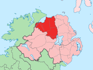
County Londonderry, also known as County Derry, is one of the six counties of Northern Ireland, one of the thirty-two counties of Ireland and one of the nine counties of Ulster. Before the partition of Ireland, it was one of the counties of the Kingdom of Ireland from 1613 onward and then of the United Kingdom after the Acts of Union 1800. Adjoining the north-west shore of Lough Neagh, the county covers an area of 2,118 km2 (818 sq mi) and today has a population of about 252,231.

Limavady is a market town in County Londonderry, Northern Ireland, with Binevenagh as a backdrop. Lying 17 miles (27 km) east of Derry and 14 miles (23 km) southwest of Coleraine, Limavady had a population of 11,279 people at the 2021 Census. In the 40 years between 1971 and 2011, Limavady's population nearly doubled. Limavady is within Causeway Coast and Glens Borough.

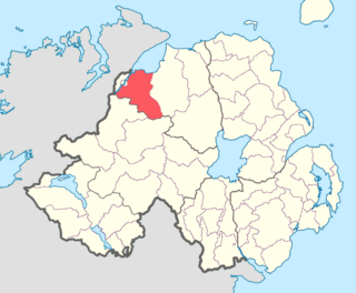
Castlederg is a town in County Tyrone, Northern Ireland. It lies on the River Derg and is near the border with County Donegal, Ireland. It stands in the townlands of Castlesessagh and Churchtown, in the historic barony of Omagh West and the civil parish of Urney. The village has a ruined castle and two ancient tombs known as the Druid's Altar and Todd's Den. It had a population of 2,980 people at the 2021 census.

Draperstown is a village in the Sperrin Mountains in County Londonderry, Northern Ireland. It is situated in the civil parish of Ballinascreen and is part of Mid-Ulster district. It is also part of the Church of Ireland parish of Ballynascreen and the Catholic parish of Ballinascreen, and within the former barony of Loughinsholin.
Newbuildings or New Buildings is a large village in County Londonderry, Northern Ireland. It lies close to the banks of the River Foyle and 3 mi (5 km) south of the city of Derry. It had a population of 3,381 in the 2011 Census. It is within Derry and Strabane district.

The Claudy bombing occurred on 31 July 1972, when three car bombs exploded mid-morning, two on Main Street and one on Church Street in Claudy in County Londonderry, Northern Ireland. The attack killed nine civilians, injured thirty and became known as "Bloody Monday". Those who planted the bombs had attempted to send a warning before the explosions took place. The warning was delayed, however, because the telephones were out of order due to an earlier bomb attack. The Provisional Irish Republican Army (IRA) issued an immediate denial of responsibility, and later stated that "an internal court of inquiry" had found that its local unit did not carry out the attack. On the thirtieth anniversary of the bombing, there was a review of the case and in December 2002 it was revealed that the IRA had been responsible for the bomb explosions.

Ballymagorry or Ballymagory is a small village and townland in County Tyrone, Northern Ireland. It is west of Artigarvan and 5 kilometres (3.1 mi) north of Strabane. In the 2001 Census it had a population of 565. It lies within the Strabane District Council area and lies on the River Glenmornan.

Feeny is a village and townland in County Londonderry, Northern Ireland. It is between Dungiven and Claudy. In the 2011 Census it had a population of 690. Feeny lies just inside the boundary of the Sperrins Area of Outstanding Natural Beauty. It is situated within Causeway Coast and Glens district.

Greysteel or Gresteel is a village in County Londonderry, Northern Ireland. It lies 9 miles (14 km) to the east of Derry and 7 miles (11 km) to the west of Limavady on the main A2 coast road between Limavady and Derry, overlooking Lough Foyle. It is designated as a Large Village and in the 2001 Census it had a population of 1,229 people, an increase of almost 20% compared to 1991. It is situated within Causeway Coast and Glens district.

Kilrea is a village, townland and civil parish in County Londonderry, Northern Ireland. It gets its name from the ancient church that was located near where the current Church of Ireland is located on Church Street looking over the town. It is near the River Bann, which marks the boundary between County Londonderry and County Antrim. In the 2011 Census it had a population of 1,678 people. It is situated within Causeway Coast and Glens district.
Tobermore, from Irish An Tobar Mór, meaning 'the great well') is a small village in County Londonderry, Northern Ireland named after the townland of Tobermore. The village, which has a predominantly Protestant population, lies 2.5 miles (4.0 km) south-south-west of Maghera and 5.5 miles (8.9 km) north-west of Magherafelt. Tobermore is within the civil parish of Kilcronaghan and is part of Mid-Ulster District. It was also part of the former barony of Loughinsholin.
Maydown is a small village and townland in County Londonderry, Northern Ireland. It is near Derry and Strathfoyle and is within the Derry and Strabane district. In the 2001 Census, it had a population of 270 people.
Killaloo is a townland and hamlet in County Londonderry, Northern Ireland. It is about six miles southeast of Derry, on the main Derry to Belfast road. In the 2001 census, Killaloo had a population of 75 people. It is situated within Derry and Strabane district.

Caledon is a small village and townland in County Tyrone, Northern Ireland. It is in the Clogher Valley on the banks of the River Blackwater, 10 km from Armagh. It lies in the southeast of Tyrone and near the borders of County Armagh and County Monaghan. It is situated in the historic barony of Dungannon Lower and the civil parish of Aghaloo. In the 2001 Census it had a population of 387 people. It is a designated conservation area. It was historically known as Kinnaird.

Innisrush or Inishrush is a small village and townland near Glenone in County Londonderry, Northern Ireland. In the 2001 Census it had a population of 114 people. It lies within the Mid-Ulster District area.

Clady is a small village and townland in County Tyrone, Northern Ireland. It lies about 4 miles from Strabane on the River Finn and borders the Republic of Ireland. In the 2011 Census it had a population of 538 people. It is within Urney civil parish and the former barony of Strabane Lower. In local government it is part of the Derry City and Strabane District Council. The townland covers an area of 173 acres.

Banagher is a parish in County Londonderry, Northern Ireland. The parish is made up of the medieval parish of Banagher and parts of the ancient parish of Boveva and the townland of Tireighter and Park, once in the parish of Cumber. Banagher has many ancient monuments, including churches, holy wells, standing stones and chambered graves.
Tirkeeran is a barony in County Londonderry, Northern Ireland. It connects to the north-Londonderry coastline, and is bordered by four other baronies: Keenaght to the east; Strabane Lower to the south-east; North West Liberties of Londonderry to the west; and Strabane Upper to the south.

Lisbunny is a townland of 849 acres in County Londonderry, Northern Ireland, about 3 miles Claudy, near the County Tyrone/Londonderry border. It is situated within Derry and Strabane district as well as the civil parish of Cumber Upper and the historic barony of Tirkeeran.
Ballyrory is a small village and townland in County Londonderry, Northern Ireland. It is situated in the civil parish of Cumber Upper and the historic barony of Tirkeeran.


