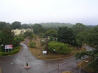
Chaibasa is a small town and a municipality in West Singhbhum district in the state of Jharkhand, India. Chaibasa is the district headquarters of West Singhbhum district. It is also the headquarter of Singhbhum Kolhan division headed by the Divisional commissioner. It consists of the main city including Sadar Bazar, Garikhana, Bari Bazar, Amla Tola, Sentola, Railway Station Area, JMP Chowk, Post Office Chowk and Gandhi Tola; and the surrounding suburbs and entry gates to the city including Tambo Chowk, Tungri, Khapparsai, Moholsai, Gutusai and Purana Chaibasa.

Rairangpur is a city and a tehsil in the Mayurbhanj district of the state of Odisha, India. It is located 287 kilometres from the state capital Bhubaneswar, 82 kilometres from the district headquarters of Baripada, and about 73 kilometres from Jamshedpur. Rairangpur is the second largest city in the Mayurbhanj district, a notable mining area of Odisha, producing iron-ore from the Gorumahisani, Badampahar, and Suleipat mines.

Chakradharpur is a municipal town situated in the West Singhbhum district of Jharkhand, India, positioned strategically on the Chota Nagpur Plateau. Located 62 kilometers west of Jamshedpur, 115 kilometers south of Ranchi, and 101 kilometers east of Rourkela, it serves as a crucial hub for the mineral-rich regions of Jharkhand and Odisha, as well as for the cement, steel, and limestone industries in the vicinity. The town spans an urban area of 10 square kilometers and stands at an elevation of 227 meters. It shares its borders with Jamshedpur to the east, Rourkela to the west, Ranchi to the north, and Chaibasa to the south, which also serves as the district headquarters of West Singhbhum.

Noamundi is a census town in West Singhbhum district in the Indian state of Jharkhand. It is also an administrative block. It is a small mining town located close to the Odisha border. It lies near Jamshedpur and 64 km (40 mi) from Chaibasa. Nearby towns include Padapahar, Barajamda, jagannathpur, Kharsawan, Gua and Kiriburu.

NMDC Limited, formerly National Mineral Development Corporation, is an Indian public sector undertaking involved in the exploration of iron ore, copper, rock phosphate, limestone, dolomite, gypsum, bentonite, magnesite, diamond, tin, tungsten, graphite, coal etc. It is India's largest iron ore producer and exporter, producing more than 35 million tonnes of iron ore from three mechanized mines in Chhattisgarh and Karnataka. It also operates the only mechanized diamond mine in the country at Panna in Madhya Pradesh.
Barbil is a town and a Municipal Council in the Kendujhar district of the state of Odisha, India. The region around Barbil has one of the largest deposits of iron ore and manganese ore in the world. It is a major source of revenue generation for both the central and the state governments.
Danguwapasi is a census town in Pashchimi Singhbhum district in the state of Jharkhand, India.
Gua is a census town in Keonjhar district in the Indian state of Orissa. It is a mining village situated in the Chotanagpur Plateau. The mines are operated by the Steel Authority of India Limited and are linked to BSL at Barbil.
Joda Town is a town and municipality in Keonjhar district, popularly known as Joda Municipality Town in Joda Block, located near Barbil City or Barbil Tahsil which is only 14 km away from. Joda Town is surrounded by the well-known Mahendragiri Parvat Shrunkhala- an ancient series of hills described in history of Bharata Varsha and in the epic Ramayana and Mahabharata, which are spread in from Keonjhar to Sundargarh, Koraput, Kandhamal, Rayagada and Visakhapatnam.

Kiriburu is a census town in Odisha. The town is mainly known for having big Iron-ore Mines KIOM & MIOM both governed by Steel Authority of India Limited (SAIL). The road connecting the township to the mines is divided by the border of Odisha and Jharkhand. It is also a famous hill station situated in the core of Saranda forest. Saranda forest is land of seven hundred hills. The name of the forest Saranda is due to the large number of elephants found in this forest. The forest has some waterfalls.
Meghahatuburu is a census town in West Singhbhum district of the Indian state of Jharkhand. The town was largely built by the Steel Authority of India Limited as it is the Raw Material Division of SAIL.
Tensa is a Town Wonder Natural Hill Station in Sundargarh District in the Indian state of Odisha. It has been declared the best mine by the Director General of Mines Safety, Govt. of India. Its origins are unknown, but it is believed it was tribal settlement prior to industrialization. In 1960 is came under the auspices of Steel Authority of India Limited (SAIL) Iron Mines. The township and ore processing plant were inaugurated by then governor of Odisha, Honourable Shri Yeshwant Narayan Sukthankar, on 25 April 1961.

Kendujhar District, is an administrative district of Odisha. The district is one of the fifth Scheduled Areas of Odisha. The town of Kendujhar is the district headquarters. The district has three sub-divisions, Anandapur, Champua, and Kendujhar.
Resources are classified as either biotic or abiotic on the basis of their origin. India contains a multitude of both types of resource and its economy, especially in rural areas, is heavily dependent on their consumption or export. Due to overconsumption, they are rapidly being depleted.
Kalunga is an Industrial Estate, which is situated at outskirts from the steel city Rourkela in Sundargarh district in Odisha state. It can be reached by both Road & Rail. Situated in the State Highway (SH-10), Rourkela to Sambalpur road.

The Tatanagar–Bilaspur section is part of the Howrah–Nagpur–Mumbai line and connects Tatanagar in the Indian state of Jharkhand and Bilaspur in Chhattisgarh. Part of one of the major trunk lines in the country, it passes through an industrial-mining area and handles high volumes of freight, particularly coal and iron ore.
Barbil railway station, located in the Indian state of Odisha, serves Barbil in Kendujhar district.

The Kharagpur–Puri Line is a railway line connecting Kharagpur in the Indian state of West Bengal and Puri in Odisha. The total line can be divided into sections. The Kharagpur–Khurda Road portion of this line, which is a part of the Howrah–Chennai main line and Khurda Road - Puri portion.
Chakradharpur railway division is one of the four railway divisions under South Eastern Railway zone of Indian Railways. This railway division was formed on 14 April 1952 and its headquarter is located at Chakradharpur in West Singhbhum district of the state of Jharkhand of India.

The Orissa Minerals Development Company Limited (OMDC),, is a Public Sector Undertaking company in the Indian states of Odisha under administrative control of Department of Steel and Mines, Government of Odisha. It was founded on August 16, 1918 and is engaged in the mining and production of iron ore and manganese ore. It is a subsidiary of state-owned Rashtriya Ispat Nigam Limited. It is listed at Calcutta Stock Exchange (CSE), National Stock Exchange of India (NSE) and Bombay Stock Exchange (BSE).


