Batesville, Texas

Last updated

Batesville, Texas
CDP
Batesville, TX, School IMG 1886.JPG
Batesville School
TXMap-doton-Batesville.PNG
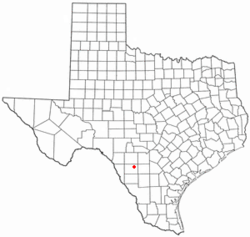
Location of Batesville, Texas
Zavala County Batesville.svg
Coordinates: 28°57′9″N99°37′46″W / 28.95250°N 99.62944°W / 28.95250; -99.62944
Country United States
State Texas
County Zavala
Area
  Total5.9 sq mi (15 km2)
  Land5.9 sq mi (15 km2)
  Water0.0 sq mi (0 km2)
Elevation
705 ft (215 m)
Population
 (2010)
  Total1,068
  Density180/sq mi (70/km2)
Time zone UTC-6 (Central (CST))
  Summer (DST) UTC-5 (CDT)
ZIP code
78829
Area code 830
FIPS code 48-05924 [1]
GNIS feature ID1351592 [2]

Batesville is a census-designated place (CDP) in Zavala County, Texas, United States. The population was 1,068 at the 2010 census.

Contents

Geography

Batesville is located at 28°57′9″N99°37′46″W / 28.95250°N 99.62944°W / 28.95250; -99.62944 (28.952424, -99.629311). The CDP had a total area of 11.6 square miles (30.0 km2), all land. Prior to the 2010 census, the CDP lost area, reducing its total area to 5.9 square miles (15 km2), all land, as before. [3] [4]

Demographics

2020 Census

Batesville racial composition [5]
(NH = Non-Hispanic) [lower-alpha 1]
RaceNumberPercentage
White (NH)719.02%
Asian (NH)40.51%
Mixed/Multi-Racial (NH)60.76%
Hispanic or Latino 70689.71%
Total787

As of the 2020 United States census, there were 787 people, 323 households, and 255 families residing in the CDP.

2000 Census

As of the census [1] of 2000, there were 1,298 people, 370 households, and 318 families residing in the CDP. The population density was 112.1 inhabitants per square mile (43.3/km2). There were 456 housing units at an average density of 39.4 per square mile (15.2/km2). The racial makeup of the CDP was 50.15% White, 0.08% African American, 0.92% Native American, 45.30% from other races, and 3.54% from two or more races. Hispanic or Latino of any race were 91.37% of the population.

There were 370 households, out of which 45.7% had children under the age of 18 living with them, 55.9% were married couples living together, 22.2% had a female householder with no husband present, and 13.8% were non-families. 11.9% of all households were made up of individuals, and 4.6% had someone living alone who was 65 years of age or older. The average household size was 3.51 and the average family size was 3.80.

In the CDP, the population was spread out, with 35.0% under the age of 18, 11.0% from 18 to 24, 27.1% from 25 to 44, 19.1% from 45 to 64, and 7.8% who were 65 years of age or older. The median age was 28 years. For every 100 females, there were 97.9 males. For every 100 females age 18 and over, there were 94.0 males.

The median income for a household in the CDP was $17,448, and the median income for a family was $18,571. Males had a median income of $18,548 versus $13,333 for females. The per capita income for the CDP was $6,969. About 33.3% of families and 43.3% of the population were below the poverty line, including 52.6% of those under age 18 and 62.4% of those age 65 or over.

Education

Batesville is served by the Uvalde Consolidated Independent School District. [7] Residents attend the Batesville School (grades K-6), Morales Junior High School in Uvalde, and Uvalde High School. [8]

The first school in Batesville opened in 1884. Originally students attended Batesville High School but in 1949 they began attending high school in Uvalde. The Batesville school district consolidated with Uvalde's in 1973. [8]

Notable person

Related Research Articles

<span class="mw-page-title-main">Zavala County, Texas</span> County in Texas, United States

Zavala County is a county located in the U.S. state of Texas. As of the 2020 census, the population was 11,677. Its county seat is Crystal City. The county was created in 1858 and later organized in 1884. Zavala is named for Lorenzo de Zavala, Mexican politician, signer of the Texas Declaration of Independence, and first vice president of the Republic of Texas.

<span class="mw-page-title-main">Frio County, Texas</span> County in Texas, United States

Frio County is a county located in the U.S. state of Texas. As of the 2020 census, its population was 18,385. The county seat is Pearsall. The county was created in 1858 and later organized in 1871. Frio is named for the Frio River, whose name is Spanish for "cold".

<span class="mw-page-title-main">Salem, Saline County, Arkansas</span> CDP in Arkansas, United States

Salem is a census-designated place (CDP) in Saline County, Arkansas, United States. Per the 2020 census, the population was 2,544. It is part of the Little Rock–North Little Rock–Conway Metropolitan Statistical Area.

<span class="mw-page-title-main">Cameron Park, Texas</span> CDP in Texas, United States

Cameron Park is a census-designated place (CDP) in Cameron County, Texas, United States. The population was 6,963 at the 2010 census. It is part of the Brownsville–Harlingen Metropolitan Statistical Area.

<span class="mw-page-title-main">Lago, Texas</span> Census-designated place in Texas, United States

Lago is a census-designated place (CDP) in Cameron County, Texas, United States. The population was 204 at the 2010 census. It is part of the Brownsville–Harlingen Metropolitan Statistical Area.

<span class="mw-page-title-main">Brundage, Texas</span> Census-designated place in Texas, United States

Brundage is an unincorporated community and census-designated place (CDP) in Dimmit County, Texas, United States. The population was 27 at the 2010 census.

<span class="mw-page-title-main">Cumings, Texas</span> Census-designated place in Texas, United States

Cumings is an unincorporated community and census-designated place (CDP) in Fort Bend County, Texas, United States. The population was 981 at the 2010 census.

<span class="mw-page-title-main">Los Ebanos, Hidalgo County, Texas</span> Census-designated place in Texas

Los Ebanos is a census-designated place (CDP) in Hidalgo County, Texas. The population was 335 at the 2010 United States Census. It is part of the McAllen–Edinburg–Mission Metropolitan Statistical Area. The city is named after the Texas Ebony that anchors the Los Ebanos Ferry.

<span class="mw-page-title-main">Linn, Texas</span> Census-designated place in Texas

Linn, formerly San Manuel-Linn, is an unincorporated area and census-designated place (CDP) in Hidalgo County, Texas, United States. The population was 801 at the 2010 census, down from 958 at the 2000 census. It is part of the McAllen–Edinburg–Mission Metropolitan Statistical Area.

<span class="mw-page-title-main">El Refugio, Texas</span> CDP in Texas, United States

El Refugio is a census-designated place (CDP) in Starr County, Texas, United States. The population was 331 at the 2010 census. El Refugio gained area in the 2010 census.

<span class="mw-page-title-main">La Victoria, Texas</span> CDP in Texas, United States

La Victoria is a census-designated place (CDP) in Starr County, Texas, United States. La Victoria went through some changes prior to the 2010 census. It gained area, had parts taken to form new CDPs, and lost additional area. Only a small part of 2010 La Victoria CDP was within the 2000 La Victoria CDP. The population was only 171 at the 2010 census down from 1,683 at the 2000 census.

<span class="mw-page-title-main">Las Lomas, Texas</span> CDP in Texas, United States

Las Lomas is a census-designated place (CDP) in Starr County, Texas, United States. The population was 3,147 at the 2010 census. Las Lomas is one of several colonias in Starr County, within the Rio Grande Valley region. The name is derived from the community's terrain.

<span class="mw-page-title-main">Knippa, Texas</span> Census-designated place in Texas, United States

Knippa is a census-designated place (CDP) in Uvalde County, Texas, United States. The population was 689 at the 2010 census.

<span class="mw-page-title-main">Uvalde Estates, Texas</span> Census-designated place in Texas, United States

Uvalde Estates is a census-designated place (CDP) in Uvalde County, Texas, United States. The population was 2,171 at the 2010 census.

<span class="mw-page-title-main">Cienegas Terrace, Texas</span> CDP in Texas, United States

Cienegas Terrace is a census-designated place (CDP) in Val Verde County, Texas, United States. The population was 3,424 at the 2010 census.

<span class="mw-page-title-main">Bruni, Texas</span> CDP in Texas, United States

Bruni is a census-designated place (CDP) in Webb County, Texas, United States. The population was 379 at the 2010 census.

<span class="mw-page-title-main">Oilton, Texas</span> CDP in Texas, United States

Oilton is a census-designated place (CDP) in Webb County, Texas, United States. The population was 152 at the 2010 census. The community is within the boundary of Webb Consolidated Independent School District and is home to the Oilton Elementary School.

<span class="mw-page-title-main">Chula Vista, Zavala County, Texas</span> CDP in Texas, United States

Chula Vista is a census-designated place (CDP) in Zavala County, Texas, United States. The population was 450 at the 2010 census. Prior to the 2010 census, the CDP was known as Chula Vista-River Spur.

<span class="mw-page-title-main">La Pryor, Texas</span> CDP in Texas, United States

La Pryor is a census-designated place (CDP) in Zavala County, Texas, United States. Its population was 1,643 at the 2010 census.

<span class="mw-page-title-main">Las Colonias, Texas</span> Former CDP in Texas, United States

Las Colonias was a census-designated place (CDP) in Zavala County, Texas, United States. The population was 283 at the 2000 census. Prior to the 2010 census, parts of this former CDP were used to create the new Amaya and Loma Grande CDPs.

References

  1. 1 2 "U.S. Census website". United States Census Bureau . Retrieved January 31, 2008.
  2. "US Board on Geographic Names". United States Geological Survey. October 25, 2007. Retrieved January 31, 2008.
  3. "US Gazetteer Files 2016-Places-Texas". US Census. Retrieved January 9, 2017.
  4. "Population and Housing Unit Counts, 2010 Census of Population and Housing" (PDF). Texas: 2010. Retrieved January 10, 2017.
  5. "Explore Census Data". data.census.gov. Retrieved May 20, 2022.
  6. "About the Hispanic Population and its Origin". www.census.gov. Retrieved May 18, 2022.
  7. "2020 CENSUS - SCHOOL DISTRICT REFERENCE MAP: Zavala County, TX" (PDF). U.S. Census Bureau . Retrieved May 24, 2022.
  8. 1 2 "Our district" (Archive). Uvalde Consolidated Independent School District. Retrieved on September 3, 2015.
  1. Note: the US Census treats Hispanic/Latino as an ethnic category. This table excludes Latinos from the racial categories and assigns them to a separate category. Hispanics/Latinos can be of any race. [6]