Bath, Michigan

Last updated

Bath, Michigan
Bath (CDP), MI location.png
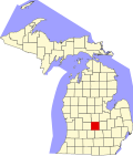
Location within Clinton County
USA Michigan location map.svg
Red pog.svg
Bath
Location within the state of Michigan
Usa edcp location map.svg
Red pog.svg
Bath
Location within the United States
Coordinates: 42°49′12″N84°27′16″W / 42.82000°N 84.45444°W / 42.82000; -84.45444 [1]
CountryUnited States
State Michigan
County Clinton
Township Bath
Platted 1864
Area
[2]
  Total6.06 sq mi (15.69 km2)
  Land5.86 sq mi (15.18 km2)
  Water0.20 sq mi (0.52 km2)
Elevation
[1]
824 ft (251 m)
Population
 (2020)
  Total2,841
  Density484.81/sq mi (187.17/km2)
Time zone UTC−5 (Eastern (EST))
  Summer (DST) UTC−4 (EDT)
ZIP code(s)
48808
Area code 517
FIPS code 26-05880 [3]
GNIS feature ID2583717 [1]

Bath is an unincorporated community and census-designated place (CDP) in Clinton County in the U.S. state of Michigan. It is located in Bath Charter Township. As of the 2010 census, the CDP had a population of 2,083. [4]

Contents

History

Bath was platted in 1864. [5]

The community of Bath was listed as a newly-organized census-designated place for the 2010 census, meaning it now has officially defined boundaries and population statistics for the first time. [6]

American supercentenarian Irene Dunham was born in Bath.

Bath School disaster

On May 18, 1927, in what became known as the Bath School disaster, Andrew Kehoe, a farmer and local school board member angry over losing an election for town clerk and under notice for foreclosure, killed his wife, detonated bombs in his house and farm buildings, and at the same time set off a bomb in the consolidated school. He drove to the school in a truck rigged with more explosives, which he detonated next to the school superintendent. In all, Kehoe killed 44 people, 38 of them children, and himself, in the worst school mass murder in U.S. history. Only half of the 1,000 pounds (450 kg) of explosives set under the school went off, probably greatly lowering the death toll. Thirty-eight of the 314 students, three teachers, the superintendent, the postmaster, and a local farmer assisting at the scene were killed. Most of the deceased were students from second to sixth grade. Fifty-eight others were injured.

Geography

According to the U.S. Census Bureau, the CDP has a total area of 5.94 square miles (15.38 km2), of which 5.74 square miles (14.87 km2) is land and 0.20 square miles (0.52 km2) (3.37%) is water. [4]

Demographics

Historical population
CensusPop.Note
2020 2,841
U.S. Decennial Census [7]

See also

Related Research Articles

<span class="mw-page-title-main">Argentine, Michigan</span> Census-designated place & unincorporated community in Michigan, United States

Argentine is an unincorporated community and census-designated place (CDP) in Argentine Township, Genesee County, in the U.S. state of Michigan. The population was 2,685 as of the 2020 census, up from 2,525 at the 2010 census. It was first settled in 1836.

<span class="mw-page-title-main">Williamstown Township, Michigan</span> Civil township in Michigan, United States

Williamstown Township is a civil township of Ingham County in the U.S. state of Michigan. As of the 2020 census, the township population was 5,286. The city of Williamston occupies the southeast corner of the township, but the two are administered autonomously.

<span class="mw-page-title-main">Atlanta, Michigan</span> Census-designated place in Michigan, United States

Atlanta is a census-designated place and unincorporated community in the U.S. state of Michigan. It is the county seat of Montmorency County. The community had a population of 720 at the 2020 census, down from 827 in 2010. Atlanta has been nicknamed the "Elk Capital of Michigan".

<span class="mw-page-title-main">Whitmore Lake, Michigan</span> Census-designated place & unincorporated community in Michigan, United States

Whitmore Lake is a census-designated place (CDP) and unincorporated community in the U.S. state of Michigan. The community spans the boundary between Green Oak Township in Livingston County and Northfield Township in Washtenaw County. The population of the CDP was 7,584 at the 2020 census.

<span class="mw-page-title-main">Bay Port, Michigan</span> Census-designated place & unincorporated community in Michigan, United States

Bay Port is an unincorporated community and census-designated place (CDP) in Huron County in the U.S. state of Michigan. The population was 582 at the 2020 census. As an unincorporated community, Bay Port has no legal autonomy of its own but does have its own post office with the 48720 ZIP Code.

<span class="mw-page-title-main">Carp Lake, Michigan</span> Census-designated place & unincorporated community in Michigan, United States

Carp Lake is an unincorporated community and census-designated place (CDP) in Emmet County in the U.S. state of Michigan. As of the 2010 census, the CDP had a population of 357. It is located within Carp Lake Township.

<span class="mw-page-title-main">Brutus, Michigan</span> Census-designated place & unincorporated community in Michigan, United States

Brutus is an unincorporated community and census-designated place (CDP) in Emmet County in the U.S. state of Michigan. As of the 2010 census, the CDP had a population of 218. Brutus is located within Maple River Township.

<span class="mw-page-title-main">Marenisco, Michigan</span> Census-designated place & unincorporated community in Michigan, United States

Marenisco is an unincorporated community and census-designated place (CDP) in Marenisco Township, Gogebic County, Michigan, in the United States. As of the 2010 census, the CDP had a population of 254, out of a total population in the township of 1,727. The name of the community and the township was formed by combining the first three letters from Mary Enid Scott, the wife of E. H. Scott, a timber producer.

<span class="mw-page-title-main">Grawn, Michigan</span> Census-designated place & unincorporated community in Michigan, United States

Grawn is an unincorporated community and census-designated place (CDP) in Grand Traverse County in the U.S. state of Michigan. At the 2020 census, the community's population was 816. The community is located within Blair Township on the border with Green Lake Township.

<span class="mw-page-title-main">Haring, Michigan</span> Census-designated place & unincorporated community in Michigan, United States

Haring is an unincorporated community and census-designated place (CDP) in Wexford County in the U.S. state of Michigan. The population of the CDP was 335 as of the 2020 census. Haring is located within Haring Charter Township just north of the city of Cadillac.

<span class="mw-page-title-main">Bath School disaster</span> 1927 bombing attacks in Bath Township, Michigan

The Bath School disaster, also known as the Bath School massacre, was a series of violent attacks perpetrated by Andrew Kehoe upon the Bath Consolidated School in Bath Charter Township, Michigan, United States, on May 18, 1927. The attacks killed 38 children and 6 adults, and injured at least 58 other people. Prior to the explosions at the school, Kehoe had murdered his wife, Nellie Price Kehoe, and firebombed his farm. Arriving at the site of the school explosion, Kehoe died when he set off explosives concealed in his truck.

<span class="mw-page-title-main">Eastport, Michigan</span> Census-designated place & unincorporated community in Michigan, United States

Eastport is an unincorporated community and census-designated place (CDP) located in Antrim County in the U.S. state of Michigan. The population of the CDP was 206 at the 2020 census. It is located in Torch Lake Township, and lies on an isthmus between Torch Lake and Grand Traverse Bay.

Parkdale is an unincorporated community and census-designated place (CDP) within Manistee Township, Manistee County, Michigan, United States. Its population was 607 as of the 2020 census, down from 704 in 2010.

<span class="mw-page-title-main">Henderson, Michigan</span> Census-designated place & unincorporated community in Michigan, United States

Henderson is an unincorporated community and census-designated place (CDP) in Shiawassee County in the U.S. state of Michigan. The CDP had a population of 399 as of the 2010 census. The community is located within Rush Township. Henderson was named for early settler John Henderson, and the community was formerly referred to as Hendersonville and Hazel Green.

<span class="mw-page-title-main">South Boardman, Michigan</span> Census-designated place & unincorporated community in Michigan, United States

South Boardman is an unincorporated community and census-designated place (CDP) in Kalkaska County in the U.S. state of Michigan. At the 2010 census, the CDP had a population of 536. South Boardman is located within Boardman Township.

<span class="mw-page-title-main">Lupton, Michigan</span> Census-designated place & unincorporated community in Michigan, United States

Lupton is an unincorporated community and census-designated place (CDP) in Ogemaw County in the U.S. state of Michigan. The population of the CDP was 318 at the 2020 census. Lupton is located mostly within Rose Township with a small portion extending south into Cumming Township.

<span class="mw-page-title-main">Bendon, Michigan</span> Census-designated place & unincorporated community in Michigan, United States

Bendon is an unincorporated community and census-designated place in Benzie County in the U.S. State of Michigan. The population was 210 at the 2020 census. Bendon is located within Inland Township.

<span class="mw-page-title-main">Jennings, Michigan</span> Census-designated place & unincorporated community in Michigan, United States

Jennings is an unincorporated community and census-designated place (CDP) in Missaukee County in the U.S. state of Michigan. The population was 229 at the 2020 census, down from 264 in 2010. The CDP is located mostly in Lake Township with a small portion extending north into Caldwell Township.

<span class="mw-page-title-main">Advance, Michigan</span> Census-designated place & unincorporated community in Michigan, United States

Advance is an unincorporated community and census-designated place (CDP) in Charlevoix County in the U.S. state of Michigan. The population of the CDP was 340 at the 2020 census. The community is located along Lake Charlevoix within Eveline Township.

<span class="mw-page-title-main">Horton Bay, Michigan</span> Census-designated place & unincorporated community in Michigan, United States

Horton Bay is an unincorporated community and census-designated place (CDP) in Charlevoix County in the U.S. state of Michigan. The population of the CDP was 485 at the 2020 census. The community is located within Bay Township on northeastern shores of Lake Charlevoix.

References

  1. 1 2 3 U.S. Geological Survey Geographic Names Information System: Bath, Michigan
  2. "2020 U.S. Gazetteer Files". United States Census Bureau. Retrieved May 21, 2022.
  3. "U.S. Census website". United States Census Bureau . Retrieved January 31, 2008.
  4. 1 2 "Michigan: 2010 Population and Housing Unit Counts 2010 Census of Population and Housing" (PDF). 2010 United States Census . United States Census Bureau. September 2012. p. 19 Michigan. Retrieved January 9, 2021.
  5. Romig 1986, p. 46.
  6. "Michigan: 2010 Population and Housing Unit Counts 2010 Census of Population and Housing" (PDF). 2010 United States Census . United States Census Bureau. September 2012. p. III-5. Retrieved January 8, 2021.
  7. "Census of Population and Housing". Census.gov. Retrieved June 4, 2016.

Sources

Further reading