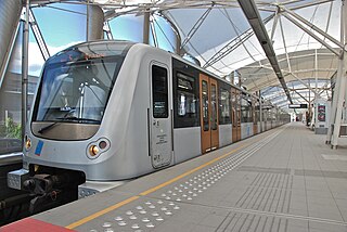
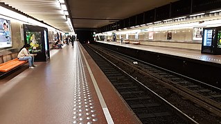
The Brussels Metro is a rapid transit system serving a large part of the Brussels-Capital Region of Belgium. It consists of four conventional metro lines and three premetro lines. The metro-grade lines are M1, M2, M5, and M6 with some shared sections, covering a total of 39.9 kilometres (24.8 mi), with 59 metro-only stations. The premetro network consists of three tram lines that partly travel over underground sections that were intended to be eventually converted into metro lines. Underground stations in the premetro network use the same design as metro stations. A few short underground tramway sections exist, so there is a total of 52.0 kilometres (32.3 mi) of underground metro and tram network. There are a total of 69 metro and premetro stations as of 2011.

De Brouckère is a rapid transit station located under the Place de Brouckère/De Brouckèreplein in central Brussels, Belgium. It consists of both a metro station and a premetro station. The station takes its name from that aboveground square, itself named after the former mayor of the City of Brussels, Charles de Brouckère.

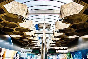
Parc (French) or Park (Dutch) is a Brussels Metro station on lines 1 and 5. It is located under Brussels Park in central Brussels, Belgium. It has one entrance, at the intersection of the Rue Royale/Koningsstraat and the Rue de la Loi/Wetstraat, two of the main roads of the City of Brussels.

Arts-Loi (French) or Kunst-Wet (Dutch) is a Brussels Metro station on lines 1, 2, 5 and 6. It is located in the City of Brussels, Belgium, under the intersection of the Rue de la Loi/Wetstraat and the Avenue des Arts/Kunstlaan, after which it is named, the latter street being part of the Small Ring.

Sainte-Catherine (French) or Sint-Katelijne (Dutch) is a Brussels Metro station on lines 1 and 5. It is located under the Place Sainte-Catherine/Sint-Katelijneplein, between the Quai aux Briques/Baksteenkaai and the Quai au Bois à Brûler/Brandhoutkaai, in the City of Brussels, Belgium. The station received its name from the aboveground Saint Catherine's Church, itself named after Saint Catherine.

Heysel (French) or Heizel (Dutch) is a Brussels Metro station on the northern branch of line 6. It is located in Laeken, in the north-west of the City of Brussels, Belgium, and serves the Heysel/Heizel Plateau, famous for the World's Fairs of 1935 and 1958, the King Baudouin Stadium and the Atomium. The Bruparck entertainment park and the Centenary Palace, home to the Brussels Exhibition Centre, are also located nearby.

Stuyvenbergh is a Brussels Metro station on the northern branch of line 6. It is located under the intersection of the Avenue Houba De Strooper/Houba De Strooperlaan, the Avenue Émile Bockstael/Émile Bockstaellaan and the Avenue De Smet De Naeyer/De Smet De Naeyerlaan, in Laeken, in the north-west of the City of Brussels, Belgium. The station takes its name from the Château of Stuyvenberg, which is just to the east, in Laeken Park.

Simonis and Elisabeth are two interconnected Brussels Metro stations serving lines 2 and 6 on two different levels, as well as a tram and bus stop. Additionally, Simonis railway station is a railway station operated by the National Railway Company of Belgium (SNCB/NMBS). It is served by the Brussels Regional Express Network (RER/GEN) service.

Beekkant is a Brussels Metro station on lines 1, 2, 5 and 6. It is located under the Boulevard Edmond Machtens/Edmond Machtenslaan in the municipality of Molenbeek-Saint-Jean, in the western part of Brussels, Belgium. The station's name translates into English as "Brookside".
Brussels-West Station is a multimodal transport hub located in the municipality of Molenbeek-Saint-Jean, in the western part of Brussels, Belgium. It mainly consists of Gare de l'Ouest (French) or Weststation (Dutch), a Brussels Metro station on lines 1, 2, 5 and 6, as well as a tram and bus stop. Additionally, Brussels-West railway station is a railway station operated by the National Railway Company of Belgium (SNCB/NMBS). It is served by the Brussels Regional Express Network (RER/GEN) service.

Porte de Hal or Hallepoort (Dutch) is a rapid transit station in Brussels, Belgium, consisting of both a metro station and a premetro station. The station is located in the municipality of Saint-Gilles, south of the City of Brussels, under the Small Ring and next to the 14th-century Halle Gate, after which it is named. It is one metro stop away or about ten minutes' walk from Brussels-South railway station.

Porte de Namur or Naamsepoort (Dutch) is a Brussels Metro station on the southern segment of lines 2 and 6. It is located under the Small Ring at the Square du Bastion/Bolwerksquare, next to the Chaussée d'Ixelles/Elsense Steenweg, in the municipality of Ixelles, south of the City of Brussels, Belgium. The station takes its name from the Namur Gate area, itself named after the Namur Gate in Brussels' old city walls.
Trône (French) or Troon (Dutch) is a Brussels Metro station on the southern segment of lines 2 and 6. It is located under the Small Ring at the Place du Trône/Troonplein, near the Royal Palace, in the City of Brussels, Belgium.
Madou is a Brussels Metro station on the northern segment of lines 2 and 6. It is located under the Small Ring at the Place Madou/Madouplein, next to Madou Plaza Tower, in the municipality of the Saint-Josse-ten-Noode, north of the City of Brussels, Belgium. The station takes its name from that aboveground square, itself named after the painter and lithographer Jean-Baptiste Madou.

Botanique (French) or Kruidtuin (Dutch) is a Brussels Metro station on the northern segment of lines 2 and 6. It is located under the Small Ring at the Rue Royale/Koningsstraat in the municipality of the Saint-Josse-ten-Noode, north of the City of Brussels, Belgium.

Rogier is a rapid transit station in Brussels, Belgium, consisting of both a metro station and a premetro station. It is located under the Small Ring at the Place Charles Rogier/Karel Rogierplein in the municipality of the Saint-Josse-ten-Noode, north of the City of Brussels. The station takes its name from that aboveground square, itself named after Charles Rogier, Belgium's 13th Prime Minister.

Yser (French) or IJzer (Dutch) is a Brussels Metro station on the northern segment of lines 2 and 6. It is located under the Small Ring, between the Place de l'Yser/IJzerplein and the Porte d'Anvers/Antwerpsepoort, in the City of Brussels, Belgium. The station takes its name from that aboveground square, itself named after the river Yser.
Ribaucourt is a Brussels Metro station on the northern segment of lines 2 and 6. It is located under the Boulevard Léopold II/Leopold II-laan in the municipality of Molenbeek-Saint-Jean, in the western part of Brussels, Belgium. The station takes its name from the Belgian noble family De Ribaucourt, as well as De Ribaucourt park and castle.

The tram route 51 in Brussels, Belgium, is a tram route operated by STIB/MIVB, which connects Heysel/Heizel metro station in the City of Brussels to the Van Haelen stop in the municipality of Uccle. The route runs north–south, crossing the City of Brussels, Jette, Molenbeek-Saint-Jean, the City of Brussels again, Saint-Gilles, Forest and Uccle. Currently, service is interrupted between Brussels-South railway station and Altitude Cent/Hoogte Honderd due to construction work at Albert premetro station.
Gare du Midi (French) or Zuidstation (Dutch) is a rapid transit station in Brussels, Belgium, consisting of both a metro station and a premetro station.