Transport in Brussels

Last updated
Rame "Boa".jpg
Ice bruxelles.JPG
De Lijn 5055 (Van Hool NewAG300) - 153 Anderlecht metro via Alsemberg - Egide van Ophem.jpg
Villo! bike rental in Brussels - Stierch.jpg
Cityrunner 3005 Brussel.jpg
Brussels Airlines A319-112 (OO-SSG) landing at Brussels Airport (1).jpg
Transportation in Brussels

Brussels has an extensive network of both private or public transportation means. Public transportation includes Brussels buses, trams, and metro (all three operated by STIB/MIVB), as well as a set of railway lines (operated by Infrabel) and railway stations served by public trains (operated by the SNCB/NMBS). Air transport is available via one of the city's two airports (Brussels Airport and Brussels South Charleroi Airport), and boat transport is available via the Port of Brussels. Bicycle-sharing and car-sharing public systems are also available. The city is relatively car-dependent by northern European standards and is considered to be the most congested city in the world according to the INRIX traffic survey. [1]

Contents

The complexity of the Belgian political landscape makes some transportation issues difficult to solve. The Brussels-Capital Region is surrounded by the Flemish and Walloon regions, which means that the airports, as well as many roads serving Brussels (most notably the Brussels Ring) are located in the other two Belgian regions. In the Brussels Region itself, two ministers are currently responsible for transport: Pascal Smet for public transport and the Port of Brussels and Bruno De Lille  [ fr ] for other transportation topics.

Metro and light rail

Brussels Metro

Development of the Brussels Metro up to 2006 Brussels-Metro-openings.gif
Development of the Brussels Metro up to 2006

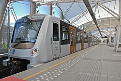
The Brussels Metro was first opened in 1976 and has been expanding since, to comprise as of 2009 a set of four metro lines serving a total of 60 metro stations, most of which are underground. Line 1 connects Gare de l'Ouest/Weststation to the east of the city. Line 2 runs in a loop around the city centre. Line 5 runs between the west to the south-east of the city via the centre. Line 6 connects the King Baudouin Stadium at the north-west of Brussels, to the city centre, ending by a loop around the centre in the same way as line 2. Lines 3 and 4 are operated by major Brussels trams.

Brussels trams

A tram arriving at De Brouckere premetro station Metro bruxelles station debrouckere.jpg
A tram arriving at De Brouckère premetro station

Brussels trams are an old transportation means in Brussels, operated by the Brussels Intercommunal Transport Company (STIB/MIVB) from 1954 on, but existing since 1869. [2] The Brussels tram system evolved a lot over time, from a rise in the first half of the 20th century (246 km (153 mi) of tram rails were serviced in 1955) [3] to a fall in the second half of the 20th century due to the popularisation of transport by bus and by car. In 1988 only 134 km (83 mi) of tram rails remained in Brussels. [4] Finally, the reduced tram network was extended in the late 2000s with the extension of existing lines from 131 km (81 mi) in 2007 to 140.6 km (87.4 mi) in 2017. [5]

Heavy rail

The Infrabel railway network has a total of eight lines used by passenger trains, which lie partly of completely within the region of Brussels. Those lines serve a total of 29 railway stations in Brussels, all of which are operated by the National Railway Company of Belgium (SNCB/NMBS) and offer connections with one or more STIB/MIVB bus, tram and/or metro lines. This system is planned to be upgraded to the Brussels Regional Express Network (RER/GEN). Brussels-South railway station is a major station on the European High Speed train network, served by TGV, Thalys, Eurostar and ICE high speed train services.

Buses

The first Brussels bus ran in 1907 from the Brussels Stock Exchange to Ixelles' Municipal Hall. [2] The Brussels bus network now comprises 360 km (220 mi) of bus line by day and 112 km (70 mi) by night as of 2008, [6] and service the 19 municipalities of Brussels. Buses operated by the Walloon (TEC) and Flemish (De Lijn) public transport companies also run in Brussels in order to allow Walloon and Flemish people to go to the capital city.

Roads

Brussels has the most congested traffic in North America and Europe according to a 2012 study by the US traffic information platform INRIX. [1]

Roads in Brussels range from highways leading to neighbouring countries or cities (the European routes E40, E411 and E19 plus the A12 and A201 highways) to national roads, major roads down to local streets. Brussels is surrounded by the Brussels Ring, and is crossed by two smaller orbital roads: the Greater Ring and the Small Ring.

Brussels buses, trams, taxis, cars and bicycles share the road network in Brussels. A car-sharing system is operated by the Bremen company Cambio, in partnership with STIB/MIVB and the local ridesharing company Taxi Stop. [7]

Airports

Brussels is served by two airports, both located outside of the administrative territory of the region. The most notable is Brussels Airport, located in the nearby Flemish municipality of Zaventem, 12 km (10 mi) east of the capital, which can be accessed by highway (A201), train and bus. The secondary airport is Brussels South Charleroi Airport, located in Gosselies, a part of the city of Charleroi (Wallonia), some 50 km (30 mi) south-west of Brussels, which can be accessed by highway (E19 then E420) or a private bus.

The Taiwanese EVA Air provides private bus services from Saint-Gilles (Sint-Gillis) (near the Brussels-South (Midi) railway station) to Amsterdam Schiphol Airport for its Belgian customers going to and from Taipei and/or Bangkok on flights departing from/arriving to Schiphol. The service is co-operated with Reizen Lauwers NV. [8]

Water transport

Brussels has its own port and is crossed by the Brussels-Charleroi Canal and the Brussels–Scheldt Maritime Canal (commonly called Willebroek Canal), which connects Brussels to Antwerp via the Scheldt.

Cycling

Villo! shared bicycles in Brussels VilloStationAlmostFull.jpg
Villo! shared bicycles in Brussels

Brussels is characterised by a relatively low level of cycling compared to Flanders and many other north-western European cities. The modal share is about 3.5% of all trips within Brussels, and 2.5% of all trips within, and entering/exiting the city. [9] However, the rate has increased significantly in recent years. Since 2009, a bicycle-sharing system named Villo! has been made available to the public.

Brussels has a high number of cycling accidents compared with Belgian rural areas but due to the urban context, most cycling accidents in Brussels result in only slight injuries. [10]

See also

Related Research Articles

<span class="mw-page-title-main">Transport in Belgium</span>

Transport in Belgium is facilitated with well-developed road, air, rail and water networks. The rail network has 2,950 km (1,830 mi) of electrified tracks. There are 118,414 km (73,579 mi) of roads, among which there are 1,747 km (1,086 mi) of motorways, 13,892 km (8,632 mi) of main roads and 102,775 km (63,861 mi) of other paved roads. There is also a well-developed urban rail network in Brussels, Antwerp, Ghent and Charleroi. The ports of Antwerp and Bruges-Zeebrugge are two of the biggest seaports in Europe. Brussels Airport is Belgium's biggest airport.

<span class="mw-page-title-main">Brussels</span> Capital region of Belgium

Brussels, officially the Brussels-Capital Region, is a region of Belgium comprising 19 municipalities, including the City of Brussels, which is the capital of Belgium. The Brussels-Capital Region is located in the central portion of the country and is a part of both the French Community of Belgium and the Flemish Community, but is separate from the Flemish Region and the Walloon Region.

<span class="mw-page-title-main">Brussels Metro</span> Public rapid-transit system serving the Brussels-Capital Region, Belgium

The Brussels Metro is a rapid transit system serving a large part of the Brussels-Capital Region of Belgium. It consists of four conventional metro lines and three premetro lines. The metro-grade lines are M1, M2, M5, and M6 with some shared sections, covering a total of 39.9 kilometres (24.8 mi), with 59 metro-only stations. The premetro network consists of three tram lines that partly travel over underground sections that were intended to be eventually converted into metro lines. Underground stations in the premetro network use the same design as metro stations. A few short underground tramway sections exist, so there is a total of 52.0 kilometres (32.3 mi) of underground metro and tram network. There are a total of 69 metro and premetro stations as of 2011.

<span class="mw-page-title-main">De Lijn</span> Flemish public transport corporation

Vlaamse Vervoersmaatschappij De Lijn, usually known as De Lijn, is a company run by the Flemish government in Belgium to provide public transportation with about 2240 buses and 399 trams. De Lijn was founded in 1991 after the public transportation companies of Antwerp and Ghent fused with the Flemish part of the NMVB.

<span class="mw-page-title-main">National Company of Light Railways</span> Belgian state-owned transportation provider

The National Company of Light Railways was a state-owned transportation provider which comprised a system of narrow-gauge tramways or local railways in Belgium, which covered the whole country, including the countryside, and had a greater route length than the mainline railway system. They were 1,000 mmmetre gauge and included electrified city lines and rural lines using steam locomotives and diesel railcars; half the system was electrified.

<span class="mw-page-title-main">Trams in Brussels</span> Belgian tram system

The Brussels tramway network is a tram system serving a large part of the Brussels-Capital Region of Belgium. It is the 16th largest tram system in the world by route length, in 2017 providing 149.1 million journeys over routes 140.6 km (87.4 mi) in length. In 2018, it consisted of 18 tram lines. Brussels trams are operated by STIB/MIVB, the local public transport company.

<span class="mw-page-title-main">Schuman railway station</span> Railway station in Brussels, Belgium

Brussels-Schuman railway station is a railway station in the City of Brussels, Belgium, serving the European Quarter. It received its name from the area around the Robert Schuman Roundabout, itself named after Robert Schuman, one of the founding fathers of the European Union.

<span class="mw-page-title-main">Opérateur de transport de Wallonie</span> Walloon public transport corporation

Opérateur de transport de Wallonie (OTW), formerly Société régionale wallonne du transport (SRWT), is responsible for the supervision, strategic planning and marketing of a group of five regional public transport directorate branded as TEC or "Transport En Commun" in Wallonia, Belgium. It is primarily a bus operator, but also operates the Charleroi tram system, and will operate the tramway in Liège once completed. TEC buses and trams are distinctively painted yellow and red.

<span class="mw-page-title-main">Brussels-Luxembourg railway station</span> Railway station in Brussels, Belgium

Brussels-Luxembourg railway station is a railway station in the European Quarter of Brussels, Belgium, under the Esplanade of the European Parliament.

<span class="mw-page-title-main">Brussels-North railway station</span> Railway and premetro station in Brussels, Belgium

Brussels-North railway station is one of the three major railway stations in Brussels, Belgium; the other two are Brussels-Central and Brussels-South. Every regular domestic and international train passing there has a planned stop. The station has 200,000 passengers per week, mainly commuters, making it one of the busiest in Belgium.

<span class="mw-page-title-main">Simonis and Elisabeth stations</span> Metro station in Brussels, Belgium

Simonis and Elisabeth are two interconnected stations on the Brussels Metro serving line 2 and line 6 on two different levels. Additionally Simonis is a railway station operated by the National Railway Company of Belgium (NMBS/SNCB) and a tram stop.

<span class="mw-page-title-main">Brussels Intercommunal Transport Company</span> Local public transport operator in Brussels, Belgium

The Brussels Intercommunal Transport Company is the local public transport operator in Brussels, Belgium. It is usually referred to in English by the double acronym STIB/MIVB, or by its French acronym, STIB.

<span class="mw-page-title-main">Brussels Airport-Zaventem railway station</span> Railway station in Flemish Brabant, Belgium

Brussels Airport-Zaventem railway station is a railway station located beneath Brussels Airport in Zaventem, Flemish Brabant, Belgium. The station opened in 1958 on railway line 36C; in 2012, the new line 25N was added. It was formerly called Brussels-National-Airport railway station until April 2016. The train services are operated by the National Railway Company of Belgium (NMBS/SNCB).

<span class="mw-page-title-main">Jette railway station</span> Railway station in Brussels, Belgium

Jette railway station is a railway station in the municipality of Jette in Brussels, Belgium, opened in 1892. The station, operated by the National Railway Company of Belgium (NMBS/SNCB), is located south of King Baudouin Park on the Place Cardinal Mercier/Kardinaal Mercierplein. It lies on line 50, between Bockstael and Berchem-Sainte-Agathe railway stations.

<span class="mw-page-title-main">Saint-Job railway station</span> Railway station in Brussels, Belgium

Saint-Job railway station or Sint-Job railway station is a railway station in the municipality of Uccle in Brussels, Belgium. The station, operated by the National Railway Company of Belgium (NMBS/SNCB), is located on line 26, between Boondael and Moensberg railway stations. The station is named after the nearby Place de Saint-Job.

<span class="mw-page-title-main">Brussels tram route 51</span> Tram route in Brussels, Belgium

The tram route 51 in Brussels, Belgium, is a tram route operated by STIB/MIVB, which connects Heysel/Heizel metro station in the City of Brussels to the Van Haelen stop in the municipality of Uccle. The route runs north–south, crossing the City of Brussels, Jette, Molenbeek-Saint-Jean, the City of Brussels again, Saint-Gilles, Forest and Uccle. Currently, service is interrupted between Brussels-South railway station and Altitude Cent/Hoogte Honderd due to construction work at Albert premetro station.

<span class="mw-page-title-main">Brussels buses</span> Bus network in Brussels, Belgium

The Brussels buses network is complementary to the rail network in Brussels, Belgium, which consists of trams, trains, and metro trains. Brussels buses are operated by STIB/MIVB, the local public transport company. It has 50 bus routes and 11 night routes, which run on Friday and Saturday night.

<span class="mw-page-title-main">Brussels S Train</span>

The Brussels S Train, also known as the Brussels Regional Express Network is a suburban rail system in and around the Brussels-Capital Region of Belgium. It will offer fast connections and increased frequency within a 30 km (19 mi) radius of the region, covering a territory inhabited by 2.5 million people.

<span class="mw-page-title-main">History of rail transport in Belgium</span>

Belgium was heavily involved in the early development of railway transport. Belgium was the second country in Europe, after Great Britain, to open a railway and produce locomotives. The first line, between the cities of Brussels and Mechelen opened in 1835. Belgium was the first state in Europe to create a national railway network and the first to possess a nationalised railway system. The network expanded fast as Belgium industrialised, and by the early 20th century was increasingly under state-control. The nationalised railways, under the umbrella organisation National Railway Company of Belgium (NMBS/SNCB), retained their monopoly until liberalisation in the 2000s.

<span class="mw-page-title-main">Braine-l'Alleud railway station</span> Railway station in Walloon Brabant, Belgium

Braine-l'Alleud railway station is a railway station in Braine-l'Alleud, Walloon Brabant, Belgium, operated by the National Railway Company of Belgium (SNCB/NMBS). The station is located on railway line 124, from Brussels-South to Charleroi-Central.

References

  1. 1 2 "Brussels and Antwerp have worst traffic". Flanders Today. 27 June 2012. Retrieved 8 December 2013.
  2. 1 2 "De 1869 à 1953". Stib.be. Archived from the original on 2013-12-21. Retrieved 2014-07-17.
  3. "De 1954 à 1959". Stib.be. Archived from the original on 2013-12-21. Retrieved 2014-07-17.
  4. "De 1980 à 1989". Stib.be. Archived from the original on 2013-12-21. Retrieved 2014-07-17.
  5. http://www.stib-mivb.be/irj/go/km/docs/WEBSITE_RES/Attachments/Corporate/Statistiques/2017/STIB_RA2017_Statistiques_FR_HDok.pdf [ bare URL PDF ]
  6. "Archived copy". Archived from the original on 2016-03-03. Retrieved 2010-03-02.{{cite web}}: CS1 maint: archived copy as title (link)
  7. "Welkom bij cambio autodelen België". Cambio autodelen. Retrieved 7 February 2016.
  8. "Between Belgium and Amsterdam Airport." EVA Air. Retrieved on February 29, 2016.
  9. Camille Thiry (ed.). "Cahiers de l'Observatoire de la mobilité de la Région de Bruxelles-Capitale: Les pratiques de déplacement à Bruxelles" (PDF) (in French). Bruxelles mobilité. p. 49. Retrieved 25 November 2013.
  10. Grégory Vandenbulcke-Plasschaert, 2011. Spatial analysis of bicycle use and accident risks for cyclists. Thèse présentée en vue de l’obtention du grade de Docteur en Sciences, Université catholique de Louvain, Louvain-la-Neuve, Novembre 2011. 318 pages.