
Transport in Belgium is facilitated with well-developed road, air, rail and water networks. The rail network has 2,950 km (1,830 mi) of electrified tracks. There are 118,414 km (73,579 mi) of roads, among which there are 1,747 km (1,086 mi) of motorways, 13,892 km (8,632 mi) of main roads and 102,775 km (63,861 mi) of other paved roads. There is also a well-developed urban rail network in Brussels, Antwerp, Ghent and Charleroi. The ports of Antwerp and Bruges-Zeebrugge are two of the biggest seaports in Europe. Brussels Airport is Belgium's biggest airport.

Transport in Luxembourg is ensured principally by road, rail and air. There are also services along the River Moselle which forms the border with Germany. The road network has been significantly modernised in recent years with motorways to adjacent countries. The advent of the high-speed TGV link to Paris has led to renovation of the city's railway station while a new passenger terminal at Luxembourg Airport has recently been opened. Trams in the capital were reintroduced in December 2017 and there are plans for light-rail lines in adjacent areas.

Brussels-South railway station, officially Brussels-South, is one of the three major railway stations in Brussels and the busiest station in Belgium. It is located in Saint-Gilles/Sint-Gillis, just south of the City of Brussels.

The HSL 1 is a high-speed rail line which connects Brussels, Belgium, with the LGV Nord at the Belgium–France border. It is 88 km (55 mi) long with 71 km of dedicated high-speed tracks and 17 km of modernised lines. Service began on 14 December 1997.
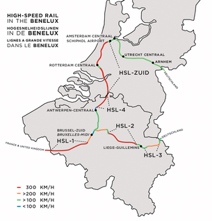
The HSL 4 is a Belgian high-speed rail line part of the 87 kilometres axis which connects Brussels to the Dutch border. It is 40 kilometres long ; 36 kilometres of it being dedicated high speed tracks. It was scheduled for completion by 2005 and opened in 2009.

European route E25 is a north–south European route from Hook of Holland in the Netherlands, to Palermo in Italy which includes ferry crossings from Genoa to Bastia (Corsica), from Bonifacio to Porto Torres (Sardinia) and from Cagliari to Palermo (Sicily).
The Autoroute 6, abbreviated to A6 or otherwise known as the Arlon motorway, is a motorway in southern and western Luxembourg. It is 20.791 kilometres (12.919 mi) long and connects Luxembourg City, in the south, to Kleinbettingen, in the west. At Kleinbettingen, it reaches the Belgian border, whereupon it meets the A4, which leads to Brussels via Arlon and Namur.
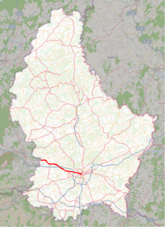
The N6 is a road in Luxembourg. It connects Luxembourg City, at its eastern end, to the Belgian border. At the border, it connects to the Belgian N4, which leads to Arlon, Namur, Wavre, and Brussels. It is also known by the name of route d'Arlon, due to the primary destination from Luxembourg City.

The Small Ring inner ring road, formally R20 and N0 is a series of roadways in central Brussels, Belgium, surrounding the historic city centre. The city centre is usually defined as the area within the Small Ring; this area is called the Pentagon due to its pentagonal shape. The pentagon forms the core of the City of Brussels municipality.
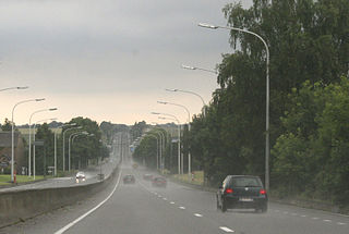
The N4 road in Belgium is a highway that runs from Brussels to Luxembourg. It starts as chaussée de Wavre at Porte de Namur on the Brussels inner ring and runs south east through Wavre and Namur, Marche-en-Famenne, Bastogne, Martelange and Arlon before terminating as route de Luxembourg at the Luxembourg border. On its route is crosses the Meuse and Lessive Rivers and the Belgian Ardennes.

Brussels-North railway station, officially Brussels-North, is one of the three major railway stations in Brussels (Belgium); the other two are Brussels-Central and Brussels-South. Every regular domestic and international train passing there has a planned stop. The station has 200,000 passengers per week, mainly commuters, making it one of the busiest in Belgium.
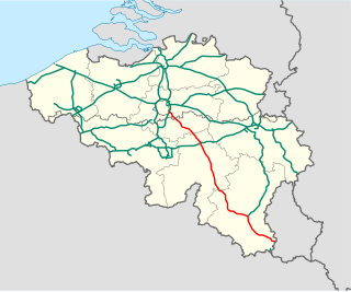
The A4 is a Belgian motorway connecting Brussels and the A6 in Luxembourg. The motorway is part of E411 between Brussels and Arlon. This motorway, the longest of Belgium (188km), is also nicknamed the "Autoroute de la Nouvelle Belgique" as opposed to the structuring axis Liège-Tournai. Indeed, the A4 connects rapidly developing centers such as Brussels and the city of Luxembourg, and it crosses economic zones full of vitality: the south-eastern suburbs of Brussels, Walloon Brabant and in particular Ottignies-Louvain-la-Neuve, Namur the new capital of Wallonia since 1986, and the country of Arlon.

Auderghem or Oudergem is one of the 19 municipalities of the Brussels-Capital Region (Belgium).
The N2 road in Belgium is a road connecting Brussels and Maastricht passing Leuven, Diest and Hasselt. It starts in Brussels at the Madou crossroad on the small ring, heading northeast as the Chaussée de Louvain/Leuvensesteenweg, which crosses the municipalities of Saint-Josse-ten-Noode, City of Brussels, Schaerbeek, Evere and Woluwe-Saint-Lambert in Brussels, and then enter Flanders via the municipality of Zaventem, Flemish Brabant.

The Brussels Ring numbered R0, is a ring road surrounding the city of Brussels as well as other smaller towns south of Brussels. It is about 75 kilometres (47 mi) long, with 2 or 3 lanes in each direction. While most of it is classified as a motorway (highway), part of it is merely an express route. It crosses the 3 regions of Belgium: its main part is situated in Flanders, whereas Wallonia comprises 18.2 kilometres (11.3 mi) of the total stretch and 5.5 kilometres (3.4 mi) is on Brussels territory.
The N3 road in Belgium is a national road connecting the capital city Brussels to Aachen in Germany via Leuven, Tienen, Sint-Truiden and Liège. Its course is quite similar to that of European route E40 between Brussels and Aachen, which it intersects 3 times. The road runs through the 3 Belgian regions and the 3 communities.
The Chaussée de Wavre (French) or Waversesteenweg (Dutch) in Brussels, Belgium is a major street crossing the municipalities of Ixelles, Etterbeek and Auderghem. It starts at a crossroad with the Chaussée d'Ixelles near the Porte de Namur square in Ixelles, goes down to the Place Jourdan in Etterbeek, then goes up to the La Chasse crossroad, continues to the Arsenal crossroad with the greater ring road. After this crossroad the street enters Auderghem, crosses the Boulevard du Souverain then merges with the European route E411 where it runs along the Rouge-Cloître and then the Sonian Forest. At its end, the road crosses the Brussels Ring. This street is part of the N4 road, which connects Brussels to Arlon.

Namur is the main railway station serving Namur, Belgium. The station is used by 18,600 people every day which makes it the eighth-busiest station in Belgium and the busiest in Wallonia.


