For Soviet transportation, see Transport in the Soviet Union.

Interstate 16 (I-16), also known as Jim Gillis Historic Savannah Parkway, is an east–west Interstate Highway located entirely within the US state of Georgia. It carries the hidden designation of State Route 404 (SR 404) for its entire length. I-16 travels from downtown Macon, at an interchange with I-75 and SR 540 to downtown Savannah at Montgomery Street (exit 167B). It also passes through or near the communities of Dublin, Metter, and Pooler. I-16's unsigned designation of SR 404 has a spur that is signed in Savannah.

Dixie Highway was a United States auto trail first planned in 1914 to connect the Midwest with the South. It was part of a system and was expanded from an earlier Miami to Montreal highway. The final system is better understood as a network of connected paved roads, rather than one single highway. It was constructed and expanded from 1915 to 1929.

The Asian Highway Network (AH), also known as the Great Asian Highway, is a cooperative project among countries in Asia and the United Nations Economic and Social Commission for Asia and the Pacific (ESCAP) to improve their connectivity via highway systems. It is one of the three pillars of the Asian Land Transport Infrastructure Development (ALTID) project, endorsed by the ESCAP commission at its 48th session in 1992, comprising Asian Highway, Trans-Asian Railway (TAR) and facilitation of land transport projects.

Samtredia is a town in Imereti, Georgia, lying in a lowland between the rivers Rioni and Tskhenis-Tsqali, 244 km (152 mi) west of the capital Tbilisi, and 27 km (17 mi) west of Georgia's third largest city Kutaisi. Georgia's most important roads and railways converge there, making Samtredia the country's vital transport hub. The Kopitnari Airport is also located in 10 km (6 mi) from Samtredia. The town's population is 25,318 as of the 2014 all-Georgia census. The climate is humid subtropical, with mild and warm winters and hot summers.

In the US state of Georgia, Interstate 20 (I-20) travels from the Alabama state line to the Savannah River, which is the South Carolina state line. The highway enters the state near Tallapoosa. It travels through the Atlanta metropolitan area and exits the state in Augusta. The highway also travels through the cities of Bremen, Douglasville, Conyers, Covington, and Madison. I-20 has the unsigned state highway designation of State Route 402 (SR 402).
FC Samtredia, commonly known simply as Samtredia, is a Georgian association football club based in the city of Samtredia.

Tskaltubo is a district of Georgia, in the region of Imereti. Its main town is Tskaltubo.

European route E 97 is an A-class European Route in Ukraine, Russia, Georgia, and Turkey. The highway runs for 1,360 kilometres (850 mi) in total. It connects the North Black Sea region with the South Black Sea region along the eastern shores of the sea.

Georgia's road network plays an important role in both domestic and international traffic with the four neighboring countries. This is expressed in the road numbering system. The country has a network of 13 internationally oriented trunk highways that connect the capital Tbilisi, home to about a third of the national population, with its four neighboring countries. This is also the backbone of a network of domestic oriented national roads connecting vital regions with each other.

The Georgian S1 route, is a "road of international importance" with a registered length of 542.7 kilometres (337.2 mi) within the Georgian classification system, which makes it the longest Georgian highway route. It runs from Tbilisi via Mtskheta, Gori, Khashuri, Zestaponi, Kutaisi, Samtredia, Senaki, Zugdidi, Sukhumi and Gagra to the border with Russia near Leselidze at the northwestern tip of the country, covering in practice 537 kilometres (334 mi). After crossing the Georgia–Russia border in breakaway Abkhazia, the highway continues to Sochi and Krasnodar as A147. It is part of European E60, E97 and E117 routes and Asian Highways AH5, AH81 and AH82, and connects with six other S-routes.

The Georgian route S2, also known as Senaki-Poti-Sarpi , is a "road of international importance" within the Georgian road network which runs from Senaki via Poti, Kobuleti, and Batumi to the border with Turkey near Sarpi (Adjara) with a length of 119 kilometres (74 mi). After crossing the Georgian-Turkish border the highway continues as D.010 to Trabzon. The S2 highway is part of European E60, E70, E97 and Asian AH5 routes and is mostly built as a 2-lane road through villages, towns and cities. Part of the highway has been upgraded in recent years to a single carriageway with hard shoulder bypassing residential communities.
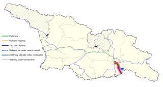
The Georgian S4 route, also known as Tbilisi–Red Bridge or Rustavi Highway, is a "road of international importance" within the Georgian road network and runs from Tbilisi via Rustavi city to the border with Azerbaijan at the Red Bridge over a distance of 57 kilometres (35 mi). After crossing the Georgian-Azerbaijan border the highway continues as M2 to Ganja and Baku.

The Georgian S5 route, also known as Tbilisi-Bakurtsikhe-Lagodekhi or Kakheti Highway, is a "road of international importance" within the Georgian road network and runs from Tbilisi via Sagarejo and Bakurtsikhe to the border with Azerbaijan near Lagodekhi over a distance of 160 kilometres (99 mi). After crossing the Georgian-Azerbaijan border the highway continues as M5 to Zagatala and Yevlakh. The S5 highway is one of the two Georgian S-highways that is not part of the European or Asian international highway routes. Within the Georgian S-network it connects with the S9 Tbilisi Bypass.

The Georgian S7 route, also known as Marneuli–Sadakhlo , is a "road of international importance" within the Georgian road network and runs from Marneuli to the border with Armenia near Sadakhlo over a distance of 34 kilometres (21 mi), making it the shortest S-highway in Georgia. After crossing the Georgian-Armenian border the highway continues as M6 to Vanadzor, Armenia's third largest city.

The Georgian S12 route, also known as Samtredia-Lanchkhuti-Grigoleti, is a 56 kilometres (35 mi) long "road of international importance" within the Georgian road network which branches off the S1 highway in Samtredia and runs to the S2 highway near Grigoleti (Guria). It is part of the main route between Kutaisi and Batumi, bypassing the Black Sea port Poti. Within the European E-road network it is referred to as E692. Most of the S12 is a two-lane road through villages and towns, while a limited part is a motorway since 2020. Upgrading the entire S12 to a four lane motorway is work in progress but experiences severe delays.

National Highway 333B, commonly referred to as Munger Ganga Bridge Road is a national highway in India. It is a spur road of National Highway 33. NH-333B traverses the state of Bihar in India.

Georgia State Route 920 (SR 920) was a 17.1-mile (27.5 km) arterial road in the Metro Atlanta area in the state of Georgia. The route number was a temporary designation placed along the route while it is upgraded to be converted to be a future alignment of SR 81. It connects the county seat of Henry County, McDonough, to the seat of Fayette County, Fayetteville via SR 54. It is known locally as Jonesboro Street in the city limits of McDonough, Jonesboro Road in Henry County, and McDonough Road in Clayton and Fayette counties. In honor of the late founder of Chick-fil-A, the majority of the route is signed as the S. Truett Cathy Highway. In August of 2023, the route was officially dissolved.

