 | |
|---|---|
| Route information | |
| Length | 2,397 km (1,489 mi) |
| Major junctions | |
| North end | Ishim, Russia |
| South end | Torugart Pass, Kyrgyzstan-China |
| Location | |
| Countries | |
| Highway system | |
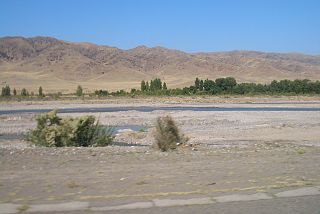
European route E125 is a Class A in Russia, Kazakhstan and Kyrgyzstan.
| | |
|---|---|
| Route information | |
| Length | 2,397 km (1,489 mi) |
| Major junctions | |
| North end | Ishim, Russia |
| South end | Torugart Pass, Kyrgyzstan-China |
| Location | |
| Countries | |
| Highway system | |
European route E125 is a Class A in Russia, Kazakhstan and Kyrgyzstan.
The E125 routes through 3 countries:
| | This European road or road transport-related article is a stub. You can help Wikipedia by expanding it. |
| | This article about transport in Kazakhstan is a stub. You can help Wikipedia by expanding it. |

Bishkek, formerly known as Pishpek and Frunze, is the capital and largest city of Kyrgyzstan. Bishkek is also the administrative centre of the Chüy Region. Bishkek is situated near the border with Kazakhstan and has a population of 1,074,075, as of 2021. Bishkek is the primate city of Kyrgyzstan—it is the sole metropolis in the country, and about 17% of all inhabitants of the country live in Bishkek's metropolitan area.
The vast territory of Kazakhstan spans across 2,700,000 km2 (1,000,000 sq mi). The population density is low in Kazakhstan, and the centers of industry and agriculture are spread out and remote from world markets.

Transport in Kyrgyzstan is severely constrained by the country's alpine topography. Roads have to snake up steep valleys, cross passes of 3,000 m (9,843 ft) altitude and more, and are subject to frequent mud slides and snow avalanches. Winter travel is close to impossible in many of the more remote and high-altitude regions. Additional problems are because many roads and railway lines built during the Soviet period are today intersected by international boundaries, requiring time-consuming border formalities to cross where they are not completely closed. The horse is still a much used transport option, especially in rural and inaccessible areas, as it does not depend on imported fuel.

Torugart Pass (Uyghur: تورغات پورتى is a mountain pass in the Tian Shan mountain range near the border between the Naryn Region of Kyrgyzstan and the Xinjiang Autonomous Region of China. It is one of two border crossings between Kyrgyzstan and China, the other being Erkeshtam, some 165 km to the southwest.

European route E40 is the longest European route, more than 8,000 kilometres long, connecting Calais in France via Belgium, Germany, Poland, Ukraine, Russia, Kazakhstan, Uzbekistan, Turkmenistan, and Kyrgyzstan, with Ridder in Kazakhstan near the border with Russia and China.

Asian Highway 7 (AH7) is a route in the Asian Highway Network. It runs from Yekaterinburg, Russia to Karachi, Pakistan. All together, it is 5,868 km (3,646 mi) long. It passes from Russia, Kazakhstan, Kyrgyzstan, Uzbekistan, Tajikistan, Afghanistan and Pakistan.

The M41, known informally and more commonly as the Pamir Highway, is a road traversing the Pamir Mountains through Afghanistan, Uzbekistan, Tajikistan and Kyrgyzstan with a length of over 1,200 km. It is the only continuous route through the difficult terrain of the mountains and is the main supply route to Tajikistan's Gorno-Badakhshan Autonomous Region. The route has been in use for millennia, as there are a limited number of viable routes through the high Pamir Mountains. The road formed one link of the ancient Silk Road trade route. M41 is the Soviet road number, but it only remains as an official designation in post-Soviet Uzbekistan, as confirmed by official decree. Kyrgyzstan and Tajikistan have passed decrees abolishing Soviet numbering of highways and assigning their own national numbering.
Jambyl or Zhambyl Region, formerly known as Dzhambul Region until 1991, is a region of Kazakhstan. Its capital is Taraz. The population of the region is 1,209,665; the city is 335,100. The region borders Kyrgyzstan, and is very near to Uzbekistan. Jambyl also borders three other provinces: Karaganda Region, Turkistan Region and Almaty Region. The total area is 144,200 square kilometres (55,700 sq mi). The province borders Lake Balkhash to its northeast. The province was named after the Kazakh akyn Jambyl Jabayev.
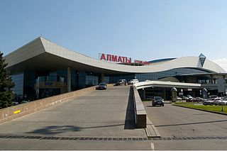
Almaty International Airport, is the largest international airport of Kazakhstan, surpassing Nursultan Nazarbayev International Airport (NQZ) in Astana and the principal hub of Air Astana. It serves Almaty, the largest and most populous city in the country, and, with its surface transport links, much of the rest of the country.

Shu, is a city in Jambyl Region of Kazakhstan.

The Bukhara–Tashkent–Bishkek–Almaty pipeline is Uzbekistan's main natural gas export pipeline.

E018 is a European class B road in Kazakhstan connecting the cities Zhezkazgan – Karagandy - Pavlodar - Uspenka.

Narxoz University is a university in Almaty, Kazakhstan offering courses in economics, business, finance, and law.

Dolon Pass is a pass located between the Songköl Too and the Bayduluu Range in Naryn Region, Kyrgyzstan. The pass lies at 3,030 metres (9,940 ft). Highway of international significance ЭМ-11 connecting Bishkek, Balykchy, Naryn, Torugart, and Kyrgyzstan-China border, which is also known as European route E125 and Asian Highway 61 in Kyrgyzstan, traverses the pass.
Ak-Beyit Pass is a pass, elevation 3,286 m (10,781 ft), that links At-Bashy Valley and Arpa Valley in Naryn Region of Kyrgyzstan. Highway of international significance ЭМ-11 connecting Bishkek, Balykchy, Naryn, Torugart, and Kyrgyzstan-China border, which is also known as European route E125 and Asian Highway 61 in Kyrgyzstan, traverses the pass.

Asian Highway 5 (AH5) is an east-west route of the Asian Highway Network, running 10,380 km (6,450 miles) from Shanghai, China via Kazakhstan, Kyrgyzstan, Uzbekistan, Turkmenistan, Azerbaijan, Georgia to the border between Turkey and Bulgaria west of Istanbul where it connects to AH1 and E80.

E 012 is a European B class road in Kazakhstan, connecting the cities of Almaty - Kokpek - Chundzha - Koktal and Khorgas to the border of China.
Qazaq Air is a Kazakh airline operating scheduled services from its main hub in Astana and focuses on domestic flights. It was established to improve the safety and availability of interregional air traffic in Kazakhstan and the border areas of neighboring states.

Asian Highway 61 or AH61 is an international route running 4,158 kilometres (2,584 mi) from Kashi in China to Krupets in Russia. This route passes through Kyrgyzstan and Kazakhstan also.
A list of roads in Kyrgyzstan.
