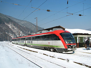
Transport in Bulgaria is dominated by road transport, despite nearly half of all paved roads belonging to the lowest category of roads. As of December 2015, the country had 829 kilometers of highways.

The Bulgarian Black Sea Coast, also known as the Bulgarian Riviera, covers the entire eastern bound of Bulgaria stretching from the Romanian Black Sea resorts in the north to European Turkey in the south, along 378 km of coastline. White and golden sandy beaches occupy approximately 130 km of the 378 km long coast. The region is an important center of tourism during the summer season (May–October), drawing millions of foreign and local tourists alike and constituting one of the country's most popular tourist destinations. Prior to 1989 the Bulgarian Black Sea coast was internationally known as the Red Riviera. Since the fall of the Iron Curtain, however, its nickname has been changed to the Bulgarian Riviera.

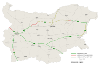
The Hemus motorway or Haemus motorway, designated A2, is a partially built motorway in Bulgaria. Its planned length is 418 km, of which 178,6 km are in operation as of June 2020. The motorway in operation is divided into two sections — the first one links the capital Sofia with Boaza near Yablanitsa, crossing Stara planina, and the second segment connects Varna and Belokopitivo near Shumen. According to the plans, Hemus motorway would connect Sofia with the third-largest city of Varna, at the Black Sea coast, duplicating European route E70 (Varna–Shumen), European route E772 (Shumen–Yablanitsa) and European route E83 (Yablanitsa–Sofia).

Levski is a town in central northern Bulgaria, an administrative center of the homonymous Levski Municipality in the very southeast of Pleven Province.

The Danubian Plain constitutes the northern part of Bulgaria, situated north of the Balkan Mountains and south of the Danube. Its western border is the Timok River and to the east it borders the Black Sea. The plain has an area of 31,523 square kilometres (12,171 sq mi). It is about 500 kilometres (310 mi) long and 20 to 120 kilometres wide.
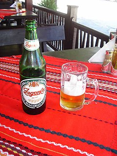
The modern history of beer in Bulgaria dates back to the 19th century, when it was introduced to the country by foreigners shortly before the Liberation of Bulgaria. Until then, beer was practically unknown in what used to be a mainly rakia and wine-drinking country. Today, Bulgaria ranks 15th by beer consumption per capita, with 73 litres a year.
Strazhitsa is a town in northeastern Bulgaria, part of Veliko Tarnovo Province. It is the administrative centre of the homonymous Strazhitsa Municipality, which lies in the eastern part of the Province. The town is located in the central Danubian Plain, not far from the Balkan Mountains, 45 kilometres northeast of the provincial capital of Veliko Tarnovo. As of December 2009, it has a population of 5,170 inhabitants.
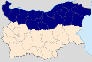
Northern Bulgaria, also called Moesia is the northern half of Bulgaria, located to the north of the main ridge of the Balkan Mountains which conventionally separates the country into a northern and a southern part. Besides the Balkan Mountains, Northern Bulgaria borders the Timok River and Serbia to the west, the Danube River and Romania to the north and the Bulgarian Black Sea Coast to the east.
The Vasil Levski National Military University is Bulgaria's national military academy.

Suhindol Municipality is a small municipality (obshtina) in Veliko Tarnovo Province, central-north Bulgaria, located in the transition between the Danubian Plain and the area of the so-called Fore-Balkan. It is named after its administrative centre – the town of Suhindol.

Pavlikeni Municipality is a municipality (obshtina) in Veliko Tarnovo Province, Central-North Bulgaria, located mostly in the Danubian Plain. It is named after its administrative centre - the town of Pavlikeni.

Strazhitsa Municipality is a municipality (obshtina) in Veliko Tarnovo Province, north-central Bulgaria, located mostly in the Danubian Plain but also covering parts of the so-called Fore-Balkan. It is named after its administrative centre – the town of Strazhitsa.

Veliko Tarnovo Municipality is a municipality (obshtina) in Veliko Tarnovo Province, Central-North Bulgaria, located mostly in the so-called Fore-Balkan area north of Stara planina mountain. It is named after its administrative centre - the old capital of the country, the city of Veliko Tarnovo which is also the main town of the province.
Highways in Bulgaria are dual carriageways, grade separated with controlled-access, designed for high speeds. In 2012, legislation amendments defined two types of highways: motorways and expressways. The main differences are that motorways have emergency lanes and the maximum allowed speed limit is 140 km/h (87 mph), while expressways do not and the speed limit is 120 km/h (75 mph). As of May 2021, a total of 831.3 kilometers of motorways are in service.

On June 19, 2014, torrential rains caused severe flash flooding across northeastern Bulgaria leaving dozens of villages without electricity and submerging large parts of several cities in the region. At least 16 people were reported killed – 13 in the Asparuhovo district of Varna, one in Dobrich and two in the village of Tsani Ganchevo in Shumen Province.

Republic road I-2 is a major road in Northeastern Bulgaria. It runs between Danube Bridge, at the Danube border with Romania, and Varna, at the Black Sea coast. It is 203 km (126 mi) long. In half of its length, between Shumen and Varna, it is superseded by Hemus motorway (A2).
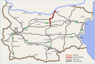
The Veliko Tarnovo–Ruse motorway is a planned motorway in Northern Bulgaria, that will link Veliko Tarnovo and Ruse, at the Danube border crossing to Romania. Planned to be designated A7, it will span for approximately 118 kilometres (73 mi), superseding the existing major road 5. Along with the Hemus motorway (A2), the Veliko Tarnovo–Ruse motorway aims to provide motorway connection between Sofia and Bucharest, the capitals of Bulgaria and Romania. Also, it follows the route of European route E85 and Pan-European Corridor IX. In March 2015, a tender for conceptual design was announced.
The Bucharest–Giurgiu Motorway, labelled A5, is a proposed motorway in the southern part of Romania, located in the historical region of Muntenia and running along the Pan-European Corridor IX. Estimated to be 51 km (32 mi) long, it will upon completion connect the capital city of Bucharest to Giurgiu, where the motorway will likely connect to Bulgaria's Veliko Tarnovo–Ruse motorway (A7), which further connects to the Hemus motorway (A2), thus serving as a motorway connection between Bucharest and Sofia, the capital city of Bulgaria.


