Transport in Croatia relies on several main modes, including transport by car, train, boat and plane. Road transport incorporates a comprehensive network of state, county and local routes augmented by a network of highways for long-distance travelling. Water transport can be divided into sea, based on the ports of Rijeka, Ploče, Split and Zadar, and river transport, based on Sava, Danube and, to a lesser extent, Drava. Croatia has 68 airports, nine of which are international. The country also has several airlines, of which the most notable are Croatia Airlines and Trade Air. Rail transport is fairly developed, with dual track and electrification not very common, although high-speed tilting trains are used on some routes. However, bus still tends to be more common than rail as a mode of inter-city transport.

Sombor is a city and the administrative center of the West Bačka District in the autonomous province of Vojvodina, Serbia. The city has a total population of 47,623, while its administrative area has 85,903 inhabitants.
The 1st Army was a Royal Yugoslav Army formation commanded by Armijski đeneral Milan Rađenković during the German-led Axis invasion of the Kingdom of Yugoslavia in April 1941 during World War II. It consisted of one infantry division, one horsed cavalry division, and two brigade-strength infantry detachments. It formed part of the 2nd Army Group, and was responsible for the defence of the section of the Yugoslav-Hungarian border between the Danube and the Tisza rivers.

Donji Tavankut, also known simply as Tavankut (Таванкут), is a village located some 16 km west of Subotica, Serbia. It is located in the Subotica municipality, in the North Bačka District of Serbia, in the Autonomous Province of Vojvodina.
Bezdan is a village located in Bačka, Vojvodina, Serbia. It is situated in the Sombor municipality, West Bačka District. The village has a Hungarian ethnic majority and its population numbers at 5,263 people.
Bački Breg is a village located in the Sombor municipality, in the West Bačka District of Serbia. It is situated in the autonomous province of Vojvodina. As of 2011, it has a population of 1,140 inhabitants. The village has a Croat (Šokac) ethnic majority.
Bački Monoštor is a village located in the municipality of Sombor, West Bačka District, Vojvodina, Serbia. As of 2011 census, it has a population of 3,485 inhabitant. The village has a Croat majority.
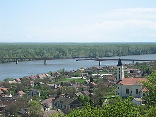
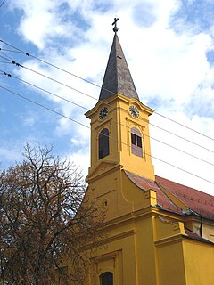
Batina is a port village on the right bank of the Danube in Baranja, Croatia. Its elevation is 105 m. Administratively, it is located in the Draž municipality within the Osijek-Baranja County.

Croatian Railways is the national railway company of Croatia. Croatia is a member of the International Union of Railways (UIC). The UIC Country Code for Croatia is 78. The Croatian rail network carried 20.270 million passengers in 2018.

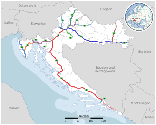
European route E73 forms part of the United Nations International E-road network, connecting Hungary and eastern Croatia to Bosnia and Herzegovina and the Adriatic Sea in the vicinity of the port of Ploče. This 679-kilometre (422 mi) route is also designated as the Pan-European Corridor Vc, a branch of the fifth Pan-European corridor. The route largely consists of two-lane roads with at-grade intersections, although in the 2000s, about a third of the route was upgraded to motorway standards. The remainder of the route is currently being upgraded in all the countries spanned. The longest part of this corridor goes through Bosnia and Herzegovina and is widely touted as a road instrumental to the development of the country. The road also serves as the shortest connection of the eastern and southern parts of Croatia.

The A5 motorway is a motorway in Croatia spanning 59 kilometres (37 mi). It connects Osijek, the largest city in Slavonia region, to the Croatian motorway network at the Sredanci interchange of the A3 motorway. The A5 represents a significant north–south transportation corridor in Croatia and is a part of the European route E73. The A5 motorway route also follows Pan-European corridor Vc. In addition to Osijek, the A5 motorway also passes near Đakovo.
Draž is a village and municipality in Osijek-Baranja County, Croatia. There are 2,767 inhabitants in the municipality.

Roads in Serbia are the backbone of its transportation system and an important part of the European road network. The total length of roads in the country is 45,419 km, and they are categorized as "state roads" or "municipal roads". All state roads in Serbia are maintained by the public, nation-wide, road construction company JP Putevi Srbije.

The A1 motorway is a motorway in Serbia and at 588 kilometers (365 mi) it is the longest motorway in Serbia. It crosses the country from north to south, starting at the Horgoš border crossing with Hungary and ending at the Preševo border crossing with North Macedonia. As a part of the European route E75 and Pan-European corridor X, connecting 4 of 5 largest Serbian cities, it is the most vital part of the Serbian road network.

D2 state road is a trunk state road in the northern areas of Croatia that spans from the border crossing with Slovenia at Dubrava Križovljanska in the west via Varaždin, Koprivnica, Virovitica, Našice, Osijek, Vukovar, ending at the Ilok–Bačka Palanka Bridge border crossing with Serbia. The road is 347.9 km (216.2 mi) long.

The D46 state road in the eastern part of Croatia connects the cities and towns of Đakovo and Vinkovci to the state road network of Croatia, and to the border with Serbia. The road is 73.0 km (45.4 mi) long. The route comprises some urban intersections, mostly in the cities Đakovo and Vinkovci, though it bypasses most of the latter city and is planned to bypass it completely.

D212 is a state road in Baranya region of Croatia connecting Batina and nearby border crossing to Bezdan, Vojvodina, Serbia to D7 state road north of Čeminac. The road is 22.1 km (13.7 mi) long.

Croatian National Council of the Republic of Serbia is the representative body of Croats in Serbia, established for the protection of the rights and the minority self-government of Croats in Serbia.

Bačka Oblast was one of the oblasts of the Kingdom of Serbs, Croats and Slovenes from 1922 to 1929. Its administrative center was Novi Sad.

The border between Croatia and Serbia in the area of the Danube is disputed. While Serbia holds the opinion that the thalweg of the Danube valley and the centerline of the river represents the international border between the two countries, Croatia disagrees and claims that the international border lies along the boundaries of the cadastral municipalities located along the river—departing from the course at several points along a 140-kilometre (87 mi) section. The cadastre-based boundary reflects the course of the Danube which existed in the 19th century, before meandering and hydrotechnical engineering works altered its course. The area size of the territory in dispute is reported variously, up to 140 square kilometres.