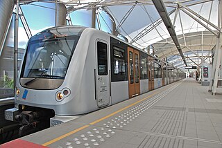
The Brussels Metro is a rapid transit system serving a large part of the Brussels-Capital Region of Belgium. It consists of four conventional metro lines and three premetro lines. The metro-grade lines are M1, M2, M5, and M6 with some shared sections, covering a total of 39.9 kilometres (24.8 mi), with 59 metro-only stations. The premetro network consists of three tram lines that partly travel over underground sections that were intended to be eventually converted into metro lines. Underground stations in the premetro network use the same design as metro stations. A few short underground tramway sections exist, so there is a total of 52.0 kilometres (32.3 mi) of underground metro and tram network. There are a total of 69 metro and premetro stations as of 2011.

Arts-Loi (French) or Kunst-Wet (Dutch) is a Brussels Metro station on lines 1, 2, 5 and 6. It is located in the City of Brussels, Belgium, under the intersection of the Rue de la Loi/Wetstraat and the Avenue des Arts/Kunstlaan, after which it is named, the latter street being part of the Small Ring.

Merode is a railway and metro station in Brussels, Belgium. It lies in the municipality of Etterbeek, near the border between Etterbeek, the City of Brussels and Schaerbeek. The metro end is under the Porte de Tervueren/Tervuursepoort, which is the start of the Avenue de Tervueren/Tervurenlaan, a major thoroughfare, while the mainline railway station end is under the Square Princesse Jean de Mérode/Prinses Jean de Mérodeplein. The two stations are connected by a long underground concourse punctuated by ticket barriers. The area is named in honour of the Princess Jean de Mérode.

Maelbeek or Maalbeek is a Brussels Metro station on lines 1 and 5. It is located under the Rue de la Loi/Wetstraat in the City of Brussels, Belgium. The station takes its name from the nearby Maalbeek stream.
Brussels-West Station is a multimodal transport hub located in the municipality of Molenbeek-Saint-Jean, in the western part of Brussels, Belgium. It mainly consists of Gare de l'Ouest (French) or Weststation (Dutch), a Brussels Metro station on lines 1, 2, 5 and 6, as well as a tram and bus stop. Additionally, Brussels-West railway station is a railway station operated by the National Railway Company of Belgium (SNCB/NMBS). It is served by the Brussels Regional Express Network (RER/GEN) service.
Stockel or Stokkel is a Brussels Metro station serving as the eastern terminus of line 1. It is located in the municipality of Woluwe-Saint-Pierre, in the eastern part of Brussels, Belgium.

Veeweyde or Veeweide is a Brussels Metro station on the western branch of line 5. It is located in the municipality of Anderlecht, in the western part of Brussels, Belgium. The station takes its name from the nearby street Rue de Veeweyde/Veeweidestraat.

Montgomery is an underground station on the Brussels Metro, the first station on the eastern branch of line 1, in the Brussels-Capital Region, Belgium. The station also serves a number of tram lines and buses: Brussels tram routes 7 and 25 pass through, and 39 and 44 terminate there, while tram route 81 and a number of buses stop at surface level.

Joséphine-Charlotte is a Brussels Metro station on the eastern branch of line 1. It is located in the municipality of Woluwe-Saint-Lambert, in the eastern part of Brussels, Belgium. The station is located entirely below the Avenue de Broqueville/De Broquevillelaan. The station, like the green square adjacent to its entrance, is named after Grand Duchess Joséphine-Charlotte of Luxembourg.

Gribaumont is a Brussels Metro station on the eastern branch of line 1. It is located in the municipality of Woluwe-Saint-Lambert, in the eastern part of Brussels, Belgium. It is located under the Avenue de Broqueville/De Broquevillelaan and takes its name from the nearby Avenue Louis Gribaumont/Louis Gribaumontlaan, named after the landowner who helped develop the area in the 1900s.
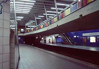
Tomberg is a Brussels Metro station on the eastern branch of line 1. It is located in the municipality of Woluwe-Saint-Lambert, in the eastern part of Brussels, Belgium; one of the entrances of the station is directly beneath the Municipal Hall.

Roodebeek is a Brussels Metro station on the eastern branch of line 1. It is located in the municipality of Woluwe-Saint-Lambert, in the eastern part of Brussels, Belgium. The station serves the Woluwe Shopping Centre and a bus interchange. It takes its name from the nearby Roodebeek Park.

Vandervelde is a Brussels Metro station on the eastern branch of line 1 It is located in the municipality of Woluwe-Saint-Lambert, in the eastern part of Brussels, Belgium. It is named after the Avenue Émile Vandervelde/Émile Vanderveldelaan, which it serves.
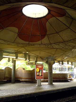
Alma is a Brussels Metro station on the eastern branch of line 1. It is located in the municipality of Woluwe-Saint-Lambert, in the eastern part of Brussels, Belgium, serving the Brussels-Woluwe campus of the University of Louvain (UCLouvain). Designed by Lucien Kroll as a total artwork, it takes its name from its location on the Place de l'Alma/Almaplein, the university campus' main square.

The tram route 39 in Brussels, Belgium, is a tram route operated by STIB/MIVB, which connects Montgomery metro station in the municipality of Woluwe-Saint-Pierre to the Ban Eik stop in the Flemish municipality of Wezembeek-Oppem.

The tram route 44 in Brussels, Belgium, is a tram route operated by STIB/MIVB, which connects Montgomery metro station in the municipality of Woluwe-Saint-Pierre to the Flemish municipality of Tervuren, almost exclusively by running on the Avenue de Tervueren/Tervurenlaan.
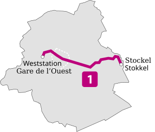
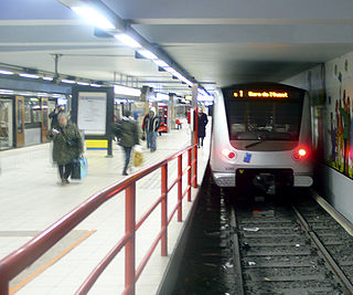
Line 1 is a rapid transit line on the Brussels Metro in Belgium operated by STIB/MIVB. It has existed in its current form since 4 April 2009, when former line 1B, which ran between Stockel/Stokkel and Erasme/Erasmus, was shortened to Gare de l'Ouest/Weststation. The section between Gare de l'Ouest and Erasme is now served by line 5. The line serves 21 metro stations, and has a common section with line 5 between Gare de l'Ouest and Merode, and with lines 2 and 6 between Gare de l'Ouest and Beekkant. At Arts-Loi/Kunst-Wet, the line also connects with lines 2 and 6. Railway connections are possible at Brussels-Central, Brussels-Schuman, Merode and Brussels-West. The line crosses the municipalities of Molenbeek-Saint-Jean, Koekelberg, City of Brussels, Etterbeek, Woluwe-Saint-Pierre and Woluwe-Saint-Lambert.

Woluwe-Saint-Lambert or Sint-Lambrechts-Woluwe is one of the 19 municipalities of the Brussels-Capital Region, Belgium. In common with all of Brussels' municipalities, it is legally bilingual (French–Dutch). In French, it is often spelt Woluwé-Saint-Lambert to reflect the Frenchified pronunciation of what was originally a Dutch place name, but the official spelling is without an accent. The Woluwe stream, from which it takes its name, flows through the municipality.

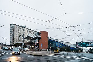
The Square Maréchal Montgomery, usually shortened to the Square Montgomery, or Montgomery by locals, is a major intersection in the Brussels municipality of Woluwe-Saint-Pierre, Belgium. It is named in honour of Field Marshal Bernard Montgomery, a senior British Army officer who served in the First World War, the Irish War of Independence and the Second World War. It is situated on the intersection of the Avenue de Tervueren/Tervurenlaan, the Boulevard Brand Whitlock/Brand Whitlocklaan and the Boulevard Saint-Michel/Sint-Michielslaan.

The Brussels Urban Transport Museum, also known as the Tram Museum, is a transport museum in Woluwe-Saint-Pierre, a municipality of Brussels, Belgium.
