Belph is a hamlet in the parish of Hodthorpe and Belph, within the district of Bolsover, in the county of Derbyshire, England. It is part of the Welbeck Abbey Estate, on the edge of modern-day Sherwood Forest. The village is 1 mile (1.6km) south-east of Hodthorpe, 1 mile (1.6km) south-east of Whitwell and 3 miles (4.8km) south-west of Worksop (where the population is listed). The village is the easternmost settlement in Derbyshire.
The village has two parts, Belph Village and Penny Green. Belph Village consists of about 30 houses either side of a single lane. A number were originally farmhouses; all except Springfield Farm are now private homes.
Penny Green consists of a row of eight labourers' cottages built in the 1900s on the Whitwell Station Road, and a large stone cottage. The latter was once the Portland Arms (a pub). On the Creswell Crags Road are Brook Cottages, three stone-built 19th-century cottages.
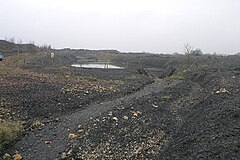
An area of the village known as the "Millash" was located where a stream flows from a natural fault. The ruins of two mills survive, the rest of the hamlet being buried under a spoil tip left by the now defunct Whitwell Colliery.
Etymology
It has long been thought that the name Belph is a corruption of the Norman French/SaxonBulgh, meaning "forest stream".[citation needed]
Bramley is a village and civil parish about three miles (5 km) south of Guildford in the Borough of Waverley in Surrey, south east England. Most of the parish lies in the Surrey Hills Area of Outstanding Natural Beauty.
New Mills is a town in the Borough of High Peak in Derbyshire, England, 8 miles (13 km) south-east of Stockport and 13 miles (21 km) from Manchester. It is situated at the confluence of the rivers Goyt and Sett, close to the border with Cheshire and above the Torrs, a 70 feet (21 m) deep gorge cut through carboniferous sandstone. It is on the north-western edge of the Peak District national park.
Swadlincote is a former mining town in the district of South Derbyshire, England, lying within The National Forest area. It borders the counties of Leicestershire and Staffordshire, 5 miles (8 km) south-east of Burton upon Trent and north-west of Ashby-de-la-Zouch, and 11.5 miles (19 km) south-west of Derby. It also covers Newhall, Oversetts, Midway and the villages of Church Gresley and Woodville, with the sub-district of Goseley. It has a population of some 36,000. Castle Gresley is 2 miles (3 km) to the south-west and Albert Village 1.5 miles (2 km) to the south.
Upper Halliford is a small village in the Borough of Spelthorne, Surrey, England approximately 24 km (15 mi) west of central London. It is part of the Shepperton post town and is in the Metropolitan Green Belt. The closest settlements are Shepperton, Charlton and Walton on Thames. St Andrew’s Baptist Church is in the southern part of the village and the settlement is in the ecclesiastical Parish of Sunbury on Thames. The conservation area surrounds the village green.
Bere Regis is a village and civil parish in Dorset, England, situated 6 miles (9.7 km) north-west of Wareham. In the 2011 census the civil parish had a population of 1,745.
Ashover is a village and civil parish in the English county of Derbyshire. It is in the North East Derbyshire district of the county. The population of the civil parish taken at the 2011 Census was 1,905. It sits in a valley, not far from the town of Matlock and the Peak District national park.
Ambergate is a village in Derbyshire, England, situated where the River Amber joins the River Derwent, and where the A610 road from Ripley and Nottingham joins the A6 that runs along the Derwent valley between Derby to the south and Matlock to the north. Sawmills and Ridgeway are neighbouring hamlets, and Alderwasley, Heage, Nether Heage and Crich are other significant neighbouring settlements. The village forms part of the Heage and Ambergate ward of Ripley Town Council with a population of 5,013 at the 2011 Census. Ambergate is within the Derwent Valley Mills UNESCO World Heritage site, and has historical connections with George Stephenson; Ambergate is notable for its railway heritage and telephone exchange. Ambergate has an active community life, particularly centred on the school, pubs, churches, sports clubs; and annual village carnival which is relatively large and consistent locally, with popular associated events in carnival week and throughout the year. The carnival is organised by a voluntary committee. Shining Cliff woods, Thacker's woods and Crich Chase border the village.
Godstone is a village and civil parish in Surrey, England, 6.3 miles (10.1 km) east of Reigate at the junction of the A22 and A25 roads, near the M25 motorway and the North Downs. Godstone railway station is separated from it by agricultural land. Blindley Heath Site of Special Scientific Interest, the Greensand Way and the North Downs Way all pass through areas of Godstone.
Sheffield is a geographically diverse city in England. It nestles in the eastern foothills of the Pennines and the confluence of five rivers: Don, Sheaf, Rivelin, Loxley and Porter. As such, much of the city is built on hillsides, with views into the city centre or out to the countryside. The city is roughly one third urban, one third rural and one third in the Peak District. At its lowest point the city stands just 29 metres above sea level at Blackburn Meadows on the Rotherham border, rising up to over 500 m in some parts of the city to a peak of 548m at High Stones on the Derbyshire border; however, 89% of the housing in the city is between 100 and 200 metres above sea level. Over 95% of the population resides in the main urban area.
Whitwell is a small village located on the south of the Isle of Wight, approximately 5 kilometres north-west of Ventnor, the village's nearest town. At the 2011 Census the appropriate civil parish was Niton and Whitwell. In addition to this, it is about five minutes away from its neighbouring small villages of Godshill and Niton, the latter of which, Whitwell forms a civil parish. According to 2001 census data, the total population of the village was 578. There is a variety of stone and thatched housing, as well as some more modern housing, the most recent of which was completed in 2006.
Warnham is a village and civil parish in the Horsham district of West Sussex, England. The village is centred 2 miles (3.2 km) north-northwest of Horsham, 31 miles (50 km) from London, to the west of the A24 road. Other named settlements within the parish include the hamlets of Goosegreen, Kingsfold and Winterfold as well as parts of Strood Green and Rowhook. The area is in the northwest of the Weald, a gently sloped remnant forest in southeast England and largely a plain by erosion.
Overseal is a village and civil parish in South Derbyshire, 3 miles (4.8 km) south of Swadlincote, 4.5 miles (7.2 km) west of Ashby-de-la-Zouch and 12.5 miles (20.1 km) due south-southwest of Derby. The population of the civil parish at the 2011 census was 2,450. Situated within the National Forest area, it is one of the southernmost settlements in Derbyshire, close to the border with Leicestershire.
Hodthorpe is an urban village in the parish of Hodthorpe and Belph, Bolsover, Derbyshire, lying close to the Nottinghamshire border and on the edge of Sherwood Forest. The village has two principal streets, Queens Road and Kings Street. It has one shop, a village primary school, and a Working Men's club. There are two parks.
Dungworth is a hamlet in the civil parish of Bradfield, west of Sheffield in South Yorkshire, England.
Toot Hill is a village in the Stanford Rivers civil parish in the Epping Forest district of Essex, England. It is 2.3 miles (4 km) south-west of Chipping Ongar and 3.5 miles (6 km) east of Epping. Toot Hill is less than a mile from the small hamlet of Clatterford End.
Epping Green is a village in the civil parish of Epping Upland and Epping Forest district of Essex, England, situated on the B181 road between Epping and Harlow.
Plumbley is a hamlet in the City of Sheffield borough, within the county of South Yorkshire in England.
Hodthorpe and Belph is a civil parish within the Bolsover district, of the county of Derbyshire, England. The parish includes the village of Hodthorpe and the hamlet of Belph. In 2011 the parish had a population of 663. It is 132 miles north west of London, 27 miles north east of the county city of Derby, and 5 miles north east of the market town of Bolsover. The parish touches Welbeck, Whitwell, Elmton with Creswell and Holbeck, and is the easternmost in Derbyshire. There is one listed building in Hodthorpe and Belph.
Brampton is a civil parish within the North East Derbyshire district, which is in the county of Derbyshire, England. Named for its main settlement, with a mix of a number of villages and hamlets amongst a large rural area, it had a population of 1,201 residents in 2011. The parish is 130 miles (210 km) north west of London, 20 miles (32 km) north of the county city of Derby, and 2 miles (3.2 km) west of the nearest market town of Chesterfield. Brampton encompasses a portion of the Peak District national park to the west, and shares a border with the district of Chesterfield, along with the parishes of Barlow, Baslow and Bubnell, Beeley, as well as Holymoorside and Walton. The parish does not include the nearby built-up suburb of Brampton which is now within the Chesterfield unparished area.
This page is based on this Wikipedia article Text is available under the CC BY-SA 4.0 license; additional terms may apply. Images, videos and audio are available under their respective licenses.