
Middlesex County is a county located in the Commonwealth of Massachusetts, United States. As of the 2020 census, the population was 1,632,002, making it the most populous county in both Massachusetts and New England and the 22nd most populous county in the United States. This also makes the county the most populous county on the East Coast outside of New York or Florida. Middlesex County is one of two U.S. counties to be amongst the top 25 counties with the highest household income and the 25 most populated counties. It is included in the Census Bureau's Boston–Cambridge–Newton, MA–NH Metropolitan Statistical Area. As part of the 2020 United States census, the Commonwealth's mean center of population for that year was geo-centered in Middlesex County, in the town of Natick.

Billerica is a town in Middlesex County, Massachusetts, United States. The population was 42,119 according to the 2020 census. It takes its name from the town of Billericay in Essex, England.

Lowell is a city in Massachusetts, United States. Alongside Cambridge, it is one of two traditional seats of Middlesex County. With an estimated population of 115,554 in 2020, it was the fifth most populous city in Massachusetts as of the last census, and the third most populous in the Boston metropolitan statistical area. The city is also part of a smaller Massachusetts statistical area, called Greater Lowell, and of New England's Merrimack Valley region.

Tewksbury is a town in Middlesex County, Massachusetts, United States. Its population was 31,342 as of the 2020 United States Census.
The Concord River is a 16.3-mile-long (26.2 km) tributary of the Merrimack River in eastern Massachusetts, United States. The river drains a small rural, suburban region northwest of Boston. As one of the most notable small rivers in U.S. history, it was the scene of an important early battle of the American Revolutionary War and was the subject of a 19th-century book by Henry David Thoreau.

The Middlesex Canal was a 27-mile (44-kilometer) barge canal connecting the Merrimack River with the port of Boston. When operational it was 30 feet wide, and 3 feet deep, with 20 locks, each 80 feet long and between 10 and 11 feet wide. It also had eight aqueducts.

The National Register of Historic Places is a United States federal official list of places and sites considered worthy of preservation. In the state of Massachusetts, there are over 4,300 listings, representing about 5% of all NRHP listings nationwide and the second-most of any U.S. state, behind only New York. Listings appear in all 14 Massachusetts counties.

John Nesmith was an American politician who served as the 25th lieutenant governor of Massachusetts in 1862.

North Billerica is an unincorporated village of the town of Billerica, Massachusetts, United States, one of the nine sections (hamlets) that make up the Town of Billerica. It is the home to Faulkner and Talbot mills and the North Billerica Train Depot. The Middlesex Canal was built through the village in 1783 and the Boston and Lowell Railroad was put through in the 1840s.

Greater Lowell is the region comprising the city of Lowell, Massachusetts, and its suburbs. These lie in northern Middlesex County, Massachusetts; in the Merrimack Valley; and in southern New Hampshire.

The Middlesex Turnpike was an early turnpike between Cambridge and Tyngsborough, Massachusetts and the New Hampshire border, where it connected with the Amherst Turnpike and thence Nashua and Claremont, New Hampshire.

The Bay Circuit Trail and Greenway or Bay Circuit is a Massachusetts rail trail and greenway connecting the outlying suburbs of Boston from Plum Island in Newburyport to Kingston Bay in Duxbury, a distance of 200 miles (320 km).
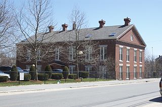
The Billerica Mills Historic District is a historic district between the Concord River, Treble Cove Terrace, Kohlrausch Avenue, Indian Road, Holt Ruggles, and Rogers Streets in the village of North Billerica, Massachusetts.
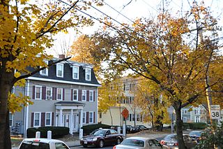
The Andover Street Historic District is a linear residential historic district in the Belvidere neighborhood of eastern Lowell, Massachusetts. The district encompasses large, fashionable houses and estates that were built between the 1860s and the 1930s. It includes properties at 245—834 Andover Street, and at 569 and 579 East Merrimack Street. The district was listed on the National Register of Historic Places in 2000.
The Colburn School is a historic former school building at 136 Lawrence Street in Lowell, Massachusetts, USA. Built in 1848, it is a fine example of institutional Greek Revival architecture, and is one of the city's older surviving school buildings, built during the rapid population growth that followed the city's industrialization. Now converted to apartments, it was listed on the National Register of Historic Places in 1995.

The Flagg-Coburn House is a historic house at 722 E. Merrimack Street in Lowell, Massachusetts. Built in 1926 for a local industrialist, it is the first known example in New England of the distinctive residential work of New York City architect Ernest Flagg. It was listed on the National Register of Historic Places in 1986.
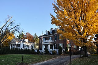
The Washington Square Historic District of Lowell, Massachusetts encompasses a historic subdivision laid out in 1832. The focal point of the subdivision is Kittridge Park, which lies on the eastern side of the district and was an original part of the subdivision plan developed by the Nesmith Brothers. It was the first significant residential subdivision in the city aimed at a wealthier clientele, and was designed by landscape architect Alexander Wadsworth. The district was added to the National Register of Historic Places in 1982, and expanded slightly in 1999.

The Merrimack Valley is a bi-state region along the Merrimack River in the U.S. states of New Hampshire and Massachusetts. The Merrimack is one of the larger waterways in New England and has helped to define the livelihood and culture of those living along it for millennia.

The Downtown Concord Historic District encompasses most of the commercial heart of downtown Concord, New Hampshire, United States. Incorporated in 1734, Concord became the state capital in 1808 and the seat of Merrimack County in 1823. Economic growth followed, due in part to these government institutions and also to the rise of industry along the Merrimack River, which flows through the city east of the downtown area, and the arrival in the 1840s of the railroad. The New Hampshire State House was built in 1819 south of the traditional center of the city, and the commercial heart of the city began to take shape along the First New Hampshire Turnpike south of the State House. The district was listed on the National Register of Historic Places in 2000.

Otis A. Merrill was an American architect. In association with various partners he practiced architecture in Lowell, Massachusetts, from 1873 until 1900.


