Bend, Texas | |
---|---|
Coordinates: 31°05′58″N98°30′46″W / 31.09944°N 98.51278°W | |
Country | United States |
State | Texas |
County | San Saba, Lampasas |
Elevation | 1,106 ft (337 m) |
Time zone | UTC-6 (Central (CST)) |
• Summer (DST) | UTC-5 (CDT) |
Area code | 325 |
GNIS feature ID | 2034958 [1] |
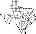
Bend is an unincorporated community in Lampasas and San Saba counties in western Central Texas. [1] Its population was 1,678 as of the 2010 census.
Settlement of the area began in the mid-19th century by farmers. In 1854, the community took the name Schleicher's Bend, after an early settler Gustav Schleicher. Other early settlers included the Low brothers. By 1856, it was called McAnelly's Bend after Robert Daugherty McAnelly, a landowner on the Lampasas side of the river. The community exists on both sides of the Colorado River, the Lampasas (west) side of the river is known locally as "Little Bend". [2]
When the application for a post office on the San Saba side of the river was made in the late 1870s, the names Little Breeches and Bend were submitted; the Bend Post Office opened in 1879 and has continuously operated ever since. Bend had a population of around 400 in 1890. For most of the 20th century, however, the community recorded 100 to 125 residents.
Bend eventually developed during the 1870s and 1880s, with a gristmill, a cotton gin, and a general store serving farmers in the area. Three churches opened here in the 1880s. A justice of the peace courthouse, a constabulary, craft shops, mercantile stores, and a hotel were in operation in 1890. Corn, cotton, and cattle were the most common commodities shipped by area farmers. The community's population was 115 from 1990 through 2000, with two businesses. [3]
Three miles south of Bend, the Victorian resort and spa of Sulphur Springs fell into disuse during the Great Depression but was revived in the 1980s as a fishing resort on the Colorado River. [2]
In the early 20th century, extensive pecan orchards were planted in the area. By the mid-century, the Hollis native pecan had become the region's cash crop. Bend boosters consider the 'Jumbo Hollis', a tree whose name is derived from its unusually large nuts and its first owner, Thomas I. Hollis, to be the world's most productive pecan tree. [2] When other native pecan trees averaged 70 to 80 nuts per pound, Jumbo's averaged 33. At the 1904 World's Fair, 'Jumbo Hollis' pecans won the bronze medal for being the largest displayed. The tree's record year was 1919, producing 1,015 pounds of nuts.
Bend is located on Farm to Market Road 580 on the western leg of a horseshoe-shaped bend in the Colorado River, 14 mi (23 km) southeast of San Saba in southeastern San Saba and western Lampasas Counties. [3] It is also located 26 mi (42 km) west of Lampasas and 95 mi (153 km) northwest of Austin via U.S. Route 183. [4]
The first school in this community opened in 1872. The Little Bend school closed in the 1920s and the Bend school was consolidated with San Saba schools in 1960. [2] The San Saba County portion of Bend is served by the San Saba Independent School District, while the Lampasas Independent School District serves Little Bend, the Lampasas County portion of the community.
Farm to Market Road 580 crosses the Colorado River at Eagle Ford Crossing, connecting Bend with Little Bend. In 1884, a cable-line ferry was installed at Eagle Ford Crossing, and it was replaced by the Regency Bridge in 1902. [5] The main road in Bend was paved in 1960. [2]
San Saba County is a county located on the Edwards Plateau in western Central Texas, United States. As of the 2020 census, its population was 5,730. Its county seat is San Saba. The county is named after the San Saba River, which flows through the county.
Mills County is a county located in Central Texas, United States. It was created on March 15, 1887, from parts of four existing counties—Brown, Comanche, Hamilton, and Lampasas—and named after John T. Mills. The 2020 census reported a population of 4,456. The county seat is Goldthwaite. A long-time resident of the county quipped that residing here is the closest a person could get to living in Mayberry.
Lampasas County is a county located on the Edwards Plateau in the U.S. state of Texas. As of the 2020 census, its population was 21,627. Its county seat is Lampasas. The county is named for the Lampasas River.
Brown County is a county in west-central Texas. As of the 2020 census, the population was 38,095. Its county seat is Brownwood. The county was founded in 1856 and organized in 1858. It is named for Henry Stevenson Brown, a commander at the Battle of Velasco, an early conflict between Texians and Mexicans.
Seguin is a city in and the county seat of Guadalupe County, Texas, United States. The population was 29,433 at the 2020 census, and according to 2023 census estimates, the city is estimated to have a population of 36,013.
San Saba is a city located in, and the county seat of, San Saba County, Texas, United States. It was settled in 1854 and named for its location on the San Saba River and for Sabbas the Sanctified. Its population was 3,099 at the 2010 census.
The pecan is a species of hickory native to the southern United States and northern Mexico in the region of the Mississippi River.
The Texas Hill Country is a geographic region of Central and South Texas, forming the southeast part of the Edwards Plateau. Given its location, climate, terrain, and vegetation, the Hill Country can be considered the border between the American Southeast and Southwest. The region represents the very remote rural countryside of Central Texas, but also is home to growing suburban neighborhoods and affluent retirement communities.
The Edwards Plateau is a geographic region forming the crossroads of Central, South and West Texas, United States. It is named in honor of Haden Edwards. It is bounded by the Balcones Fault to the south and east; the Llano Uplift and the Llano Estacado to the north; and the Pecos River and Chihuahuan Desert to the west. San Angelo, Austin, San Antonio and Del Rio roughly outline the area. The plateau, especially its southeast portion, is also known as the Texas Hill Country.
James Stephen Hogg was an American lawyer and statesman, and the 20th Governor of Texas. He was born near Rusk, Texas. Hogg was a follower of the conservative New South Creed which became popular following the U.S. Civil War, and was also associated with populism. He was the first Texas Governor to have been born in Texas. Jim Hogg County is named after him.
The Little River is a river in Central Texas in the Brazos River watershed. It is formed by the confluence of the Leon River and the Lampasas River near Little River, Texas in Bell County. It flows generally southeast for 75 miles (121 km) until it empties into the Brazos River about 5 miles (8.0 km) southwest of Hearne, at a site called Port Sullivan in Milam County. The Little River has a third tributary, the San Gabriel River, which joins the Little about 8 miles (13 km) north of Rockdale and five miles southwest of Cameron. Cameron, the county seat of Milam County and the only city of any significant size on the Little River, was established in 1846.
The San Saba River is a river in Texas, United States. It is an undeveloped and scenic waterway located on the northern boundary of the Edwards Plateau.
Cherokee is an unincorporated community in San Saba County, Texas, United States. According to the Handbook of Texas, the community had an estimated population of 175 in 2000.
The 1982 Texas gubernatorial election was held on November 2, 1982, to elect the governor of Texas. Incumbent Republican governor Bill Clements ran for reelection, but was defeated in the general election by Democrat Mark White, winning 46% of the vote to White's 53%. White was sworn into office on January 18, 1983.
Bowser is an unincorporated community in northwestern San Saba County in western Central Texas. According to the Handbook of Texas, the community had a population of 20 in 2000.
Rumley is an unincorporated community in Lampasas County, Texas, United States. According to the Handbook of Texas, the community had a population of eight in 2000. It is located within the Killeen-Temple-Fort Hood metropolitan area.