Bethesda, Arkansas | |
|---|---|
 Bethesda Bethesda's position in Arkansas  Bethesda Bethesda (the United States) | |
| Coordinates: 35°47′21″N91°47′57″W / 35.78917°N 91.79917°W | |
| Country | United States |
| State | Arkansas |
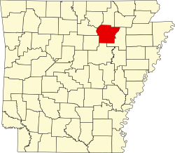
| County | Independence |
| Township | Washington |
| Elevation | 551 ft (168 m) |
| Population (2020) | |
• Total | 199 |
| Time zone | UTC-6 (Central (CST)) |
| • Summer (DST) | UTC-5 (CDT) |
| Area code | 870 |
| GNIS feature ID | 2805623 [1] |
Bethesda was an unincorporated community and census-designated place (CDP) in western Independence County, Arkansas, United States. [1] It was first listed as a CDP in the 2020 census with a population of 199. [2]
Contents
It is connected to the Arkansas Highway System via Highway 106S and is approximately eight miles west of Batesville. [3]