
Protected areas of South Australia consists of protected areas located within South Australia and its immediate onshore waters and which are managed by South Australian Government agencies. As of March 2018, South Australia contains 359 separate protected areas declared under the National Parks and Wildlife Act 1972, the Crown Land Management Act 2009 and the Wilderness Protection Act 1992 which have a total land area of 211,387.48 km2 (81,617.16 sq mi) or 21.5% of the state's area.
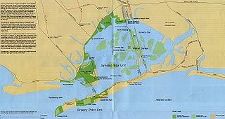
Jamaica Bay is an estuary on the southern portion of the western tip of Long Island, in the U.S. state of New York. The estuary is partially man-made, and partially natural. The bay connects with Lower New York Bay to the west, through Rockaway Inlet, and is the westernmost of the coastal lagoons on the south shore of Long Island. Politically, it is primarily divided between the boroughs of Brooklyn and Queens in New York City, with a small part touching Nassau County.

Puget Sound is a deep inlet of the Pacific Ocean in Washington, extending south from the Strait of Juan de Fuca through Admiralty Inlet. It was explored and named by Captain George Vancouver for his aide, Peter Puget, in 1792.

Wood-Tikchik State Park is a state park in the U.S. state of Alaska north of Dillingham. Over 1,600,000 acres (650,000 ha) (6,500 km2) in area—about the size of the state of Delaware—, comprising more than half of all state park land in Alaska and 15% of the total state park land in the country. Despite being the largest state park in the nation, the park had no staff whatsoever for its first five years, and even now at times only a single ranger is in charge of patrolling the entire park, usually by aircraft.

Detroit Island is an island in Lake Michigan in the southern part of the town of Washington in Door County, Wisconsin, United States. The island has a land area of 2.578 km², out of which 27.6% is open to the public. The northern end of the island borders the waters of Detroit Harbor.

The California Department of Fish and Wildlife (CDFW), formerly known as the California Department of Fish and Game (CDFG), is a state agency under the California Natural Resources Agency. The Department of Fish and Wildlife manages and protects the state's wildlife, wildflowers, trees, mushrooms, algae (kelp) and native habitats (ecosystems). The department is responsible for regulatory enforcement and management of related recreational, commercial, scientific, and educational uses. The department also prevents illegal poaching.

Hearst San Simeon State Park is a state park of California, United States, preserving rocky coast and rare habitats. It is located between Cambria and San Simeon. The 3,409-acre (1,380 ha) park was first established in 1932. The park includes the Santa Rosa Creek Natural Preserve, the San Simeon Natural Preserve and the Pa-nu Cultural Preserve, which were established in 1990.

New York State Wildlife Management Areas (WMAs) are conservation areas managed by the New York State Department of Environmental Conservation (NYSDEC) primarily for the benefit of wildlife, and used extensively by the public for hunting, fishing, and trapping. As of 2016, the NYSDEC owns and maintains 113 WMAs, with a total area of approximately 197,000 acres. The Wildlife Management Areas program is administered by the Division of Fish, Wildlife and Marine Resources of the NYSDEC.

Camden Sound is a relatively wide body of water in the Indian Ocean located in the Kimberley region of Western Australia. The Sound is bounded by the Bonaparte Archipelago to the north-east, the Buccaneer Archipelago to the south-west, and Montgomery Reef to the south.

Pacific Grove Marine Gardens State Marine Conservation Area is one of four small marine protected areas located near the cities of Monterey and Pacific Grove, at the southern end of Monterey Bay on California’s central coast. The four MPAs together encompass 2.96 square miles (7.7 km2). Within the SMCA fishing and take of all living marine resources is prohibited except the recreational take of finfish and the commercial take of giant and bull kelp by hand under certain conditions. According to the Frommer's guide, the Marine Gardens area is "renowned for ocean views, flowers, and tide-pool seaweed beds."
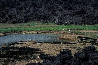
Established in 1973, ʻĀhihi-Kīnaʻu Natural Area Reserve includes a coastal lava field and surrounding waters on the southwest coast of the island of Maui, Hawaii. It consists of 1,238 acres (501 ha) on land and 807 acres (327 ha) of ocean along 3 miles (4.8 km) of Maui's southwestern coastline. The reserve includes several popular snorkeling/diving sites and many cultural and geologic sites as well as habitat for numerous rare and endangered species. The purpose and intent of the Reserve is to preserve and protect three unique components: the geologic setting of the most recent lava flow on Maui; unique assemblages of nearshore coral reef ecosystems; and the anchialine ponds found there.

Moss Landing Wildlife Area is a California State wildlife preserve on the shore of Elkhorn Slough.

Calca Peninsula is a peninsula in the Australian state of South Australia located on the west coast of Eyre Peninsula in the locality of Sceale Bay about 27 kilometres to about 46 kilometres south-east of the town of Streaky Bay.
Day Harbor is a bay on the Kenai Peninsula of Alaska, United States. It received its name in 1787 from Captain Portlock, due to the fact that travel to the head of the bay from Seward typically takes 12 hours. The bay is 25 miles from Seward, and is accessible only by boat. It is a gently curving J-shaped bay separated on the west from nearby Resurrection Bay by the Resurrection Peninsula. Recreational boaters often anchor at one of the two State Marine Parks due to the often choppy seas and unstable weather of outer Day Harbor. Lesser used anchorages on the eastern shore include Anchor Cove and Bowen Anchorage. Popular activities in the bay include hiking to Ellsworth Lake at the head of the bay where the retreating Ellsworth Glacier calves.

Chilkat State Park is a 9,837-acre Alaska state park on a peninsula south of the town of Haines, Alaska between the Chilkat and Chilkoot inlets. Remote and known for the steep 14% grade gravel access road, the park offers campsites with minimal amenities and is open to fishing, hiking, boating, sea kayaking, and sightseeing. The campground is closed from October to mid-May due to winter concerns.
Jack Bay State Marine Park is a 1,544 acre state park in the U.S. state of Alaska near Valdez. The park covers 811 acres and is nestled in Jack Bay, about an hour's boat ride from Valdez. The park is surrounded by steep mountains and a spruce-hemlock forest. There is no road access to the park; the park is only accessible by boat or plane. Popular activities include camping, fishing, kayaking, and wildlife viewing.
Canoe Passage State Marine Park is an undeveloped 2,507 acre Alaska State Park on Hawkins Island. The state park is 8 miles west of Cordova. There is no road access to the island. Popular activities include boating, fishing, hunting, camping, and kayaking. The park is surrounded by forested uplands and wetlands.
Security Bay State Marine Park is a 1,960 acre undeveloped Alaska state marine park on the north end of Kuiu Island, facing Frederick Sound and Catham Strait. The bay provides a safe haven anchorage for vessels in the area. The nearest city is Kake, about 20 miles to the east. There is no road access to the park.
Boswell Bay State Marine Park is a 3,047 acre undeveloped Alaska state marine park on the eastern tip of Hinchinbrook Island, approximately 15 miles southwest of Cordova. Areas of the park are adjacent to the Copper River Delta State Critical Habitat. In 1964, an earthquake uplifted a substantial part of the park, moving the shore inland by more than a mile.

Entry Cove State Marine Park is a 1,200 acres state marine park in the U.S. state of Alaska. The park is two miles directly east of Decision Point on the northeast corner where Passage Canal and Port Wells meet. There is no road access to the park.
