Beyul

Last updated

According to the beliefs of the Nyingma school of Tibetan Buddhism, Beyul (Tibetan : སྦས་ཡུལ, Wylie : sbas-yul) are hidden valleys often encompassing hundreds of square kilometers, which Padmasambhava blessed as refuges. Tertöns may reveal them from terma at specific and appropriate times. Their locations were kept on scrolls (lamyig or neyig) hidden under rocks and inside caves, monasteries and stupas. They are places where physical and spiritual worlds overlap, and Tantric practice effectiveness increases with multiple perception dimensions. [1]

Contents

Padmasambhava assigned deities to protect the beyul. Protective forces manifest as snowstorms, mists and snow leopards. Buddhist texts indicate beyul are discovered when the planet is approaching destruction and the world becomes too corrupt for spiritual practice. They describe valleys reminiscent of paradise, which can only be reached with enormous hardship. Pilgrims who travel to these wild and distant places often recount extraordinary experiences similar to those encountered by Buddhist spiritual practitioners on the path to liberation. People who try to force their way in may encounter failure and death. [2] [3] Earthly beyuls share significant characteristics with Shambhala. [4]

A recent attempt to open a beyul occurred in 1962, when the Tibetan lama Tulshuk Lingpa journeyed to Sikkim in order to 'open' Beyul Demoshong, a beyul fabled to exist on the slopes of Mount Kanchenjunga straddling the Nepal/Sikkim border. He took with him over 300 followers from across the Himalayas and Tibet, each of whom had supposedly given away his or her worldly goods. [5]

Nghe-Beyul at Barun Valley. Barun Valley - Nghe.jpg
Nghe-Beyul at Barun Valley.

Beyul are often understood to embody dharmapala and lords of the land, which are associated with geographic features such as mountains, trees, rocks, and water sources. Pilgrims make ritual offerings to these beings to appease their wrathful nature, and to renew the symbolic unity that people share with them. It has been argued that this attitude indicates a sustainable approach toward land stewardship. [6]

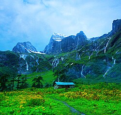
In Nepal and Tibet around Mount Everest are the Khenbalung, Solukhumbu, Rolwaling, Rongshar, Kyirong and Nubri sacred valleys. [7] The Sherpa people discovered Solukhumbu when they left Tibet to escape religious persecution in the 15th and 16th centuries. They entered the valley to seek refuge and made a new homeland there. Buddhist monasteries and sacred mountains have brought many spiritual travelers to Solukhumbu. Beyul are found in the Himalayan regions of Nepal, Tibet, Sikkim, Bhutan, India, China and Pakistan.

See also

Related Research Articles

<span class="mw-page-title-main">Kangchenjunga</span> Third highest mountain in the world

Kangchenjunga, also spelled Kanchenjunga, Kanchanjanghā and Khangchendzonga, is the third-highest mountain in the world. Its summit lies at 8,586 m (28,169 ft) in a section of the Himalayas, the Kangchenjunga Himal, which is bounded in the west by the Tamur River, in the north by the Lhonak River and Jongsang La, and in the east by the Teesta River. It lies in the border region between Nepal and Sikkim state of India, with three of the five peaks, namely Main, Central and South, directly on the border, and the peaks West and Kangbachen in Nepal's Taplejung District.

<span class="mw-page-title-main">Himalayas</span> Mountain range in Asia, separating Indo-Gangetic plain from Tibetan Plateau

The Himalayas, or Himalaya, is a mountain range in Asia, separating the plains of the Indian subcontinent from the Tibetan Plateau. The range has some of the Earth's highest peaks, including the highest, Mount Everest; more than 100 peaks exceeding elevations of 7,200 m (23,600 ft) above sea level lie in the Himalayas.

<span class="mw-page-title-main">Padmasambhava</span> 8th-century Buddhist lama

Padmasambhava, also known as Guru Rinpoche and the Lotus from Oḍḍiyāna, was a tantric Buddhist Vajra master from medieval India who taught Vajrayana in Tibet. According to some early Tibetan sources like the Testament of Ba, he came to Tibet in the 8th century and helped construct Samye Monastery, the first Buddhist monastery in Tibet. However, little is known about the actual historical figure other than his ties to Vajrayana and Indian Buddhism.

<span class="mw-page-title-main">Sherpa people</span> Tibetan ethnic group

The Sherpa are one of the Tibetan ethnic groups native to the most mountainous regions of Nepal, Tingri County in the Tibet Autonomous Region and the Himalayas. The term sherpa or sherwa derives from the Tibetan-language words ཤར shar ('east') and པ pa ('people'), which refer to their geographical origin in eastern Tibet.

Shangri-La is a fictional place in Tibet's Kunlun Mountains, described in the 1933 novel Lost Horizon by English author James Hilton. Hilton portrays Shangri-La as a mystical, harmonious valley, gently guided from a lamasery, enclosed in the western end of the Kunlun Mountains. Shangri-La has become synonymous with any earthly paradise, particularly a mythical Himalayan utopia – an enduringly happy land, isolated from the world. In the novel, the people who live in Shangri-La are almost immortal, living hundreds of years beyond the normal lifespan and only very slowly aging in appearance.

<span class="mw-page-title-main">Tengboche</span> Place in Province No. 1, Nepal

Tengboche is a village in Khumbu Pasanglhamu rural municipality in the Khumbu subregion of Province No. 1 in Nepal, located at 3,867 metres (12,687 ft). Within the village is an important Buddhist monastery, Tengboche Monastery, which is the largest gompa in the Khumbu region. The structure was built in 1923. In 1934, it was destroyed by an earthquake but subsequently rebuilt. It was destroyed again by a fire in 1989, and again rebuilt with the help of volunteers and the provision of foreign aid. Tengboche has a panoramic view of the Himalayan mountains, including the well-known peaks of Tawache, Everest, Nuptse, Lhotse, Ama Dablam, and Thamserku. Tenzing Norgay, the first man to reach the summit of Mount Everest with Sir Edmund Hillary, was born in the area in the village of Thani and was once sent to Tengboche Monastery to be a monk.

<span class="mw-page-title-main">Mount Kailash</span> Religious mountain in Tibet Autonomous Region

Mount Kailash is a mountain in Ngari Prefecture, Tibet Autonomous Region of China. It lies in the Kailash Range of the Transhimalaya, in the western part of the Tibetan Plateau. Mount Kailash is less than 100 km north of the western trijunction of the borders of China, India, and Nepal.

<span class="mw-page-title-main">Langtang</span> Region in Nepal

Langtang Valley also known as Lamtang Valley is a Himalayan valley in the mountains of north-central Nepal, known for its trekking routes and natural environment.

<span class="mw-page-title-main">Yuksom</span> Town in West Sikkim, India

Yuksom is a historical town in Geyzing subdivision of West Sikkim district in the Northeast Indian state of Sikkim. It was the first capital of Kingdom of Sikkim established in 1642 AD by Phuntsog Namgyal who was the first Chogyal of Sikkim. The coronation site of the first monarch of Sikkim is known as the "Throne of Norbugang". Yuksom is where there is the Norbugang Chorten near the Norbugang throne, the place Namgyal was crowned and several monasteries and a lake. The dynastic rule of the Chogyals lasted for 333 years.

<span class="mw-page-title-main">Namcha Barwa</span> Mountain in Tibet, China

Namcha Barwa or Namchabarwa is a mountain peak lying in Tibet in the region of Pemako. The traditional definition of the Himalaya extending from the Indus River to the Brahmaputra would make it the eastern anchor of the entire mountain chain, and it is the highest peak of its own section as well as Earth's easternmost peak over 7,600 metres (24,900 ft). It lies in the Nyingchi Prefecture of Tibet. It is the highest peak in the 180 km long Namcha Barwa Himal range, which is considered the easternmost syntaxis/section of the Himalaya in southeastern Tibet and northeastern India where the Himalaya are said to end, although high ranges actually continue another 300 km to the east.

<span class="mw-page-title-main">Dudjom Jigdral Yeshe Dorje</span>

Kyabje Dudjom Jigdral Yeshe Dorje was known as Terchen Drodül Lingpa and as Dudjom Rinpoche. He is considered by many Tibetan Buddhists to be from a line of important Tulku lineage, and a renowned Tertön. Per lineage, he was a direct incarnation of both Padmasambhava and Dudjom Lingpa (1835–1904). He was a Nyingma householder, yogi, and a Vajrayana and Dzogchen master. According to his disciple Khenpo Tsewang Dongyal, he was revered as "His Holiness" and as a "Master of Masters".

<span class="mw-page-title-main">Ayu Khandro</span> Tibetan Buddhist terton and teacher

Ayu Khandro, also known as Dorje Paldrön, was a Tibetan yogini, practitioner and terton of Tantric Buddhism in Eastern Tibet. An accomplished Dzogchen meditator, she is known for her extensive pilgrimages throughout Tibet, long periods of dark retreat practice, the gongter of the practice of the yidam Senge Dongma, various forms of Chöd, and her lifelong dedication to spiritual practice.

<span class="mw-page-title-main">Chungthang</span> Town in Sikkim, India

Chungthang is a town in Mangan District in the Indian state of Sikkim. It is situated at the confluence of the Lachen and Lachung rivers, which combine to form the Teesta River. Located at a distance of 95 kilometres (59 mi) from the state capital Gangtok, the Indian Army has a major forward base with a medical centre in Chungthang.

Chamar is the highest peak of the Sringi Himal, which is a subrange of the Nepalese Himalayas. Chamar and the entire Sringi Himal lie in Central Nepal, just south of the Tibetan border, between the Shyar Khola valley on the east and the Tom Khola–Trisuli Gandaki valley on the west. Chamar is about 90 km northwest of Kathmandu, and about 25 km east of Manaslu, the nearest eight-thousander.

<span class="mw-page-title-main">Kora (pilgrimage)</span>

Kora is a transliteration of a Tibetan word that means "circumambulation" or "revolution". Kora is both a type of pilgrimage and a type of meditative practice in the Tibetan Buddhist or Bon traditions. A Kora is performed by the practitioner making a circumambulation around a sacred site or object, typically as a constituent part of a pilgrimage, ceremony, celebration or ritual. In broader terms, it is a term that is often used to refer to the entire pilgrimage experience in the Tibetan regions.

Charles Albert Edward Ramble is an anthropologist and former University Lecturer in Tibetan and Himalayan Studies at the Oriental Institute, Oxford University. Since 2009 he has been Professor and Directeur d'études at the Ecole pratique des hautes études, Paris. Between 2006 and 2013 he was elected president of the International Association for Tibetan Studies (IATS) and convened the 10th seminar of IATS at Oxford in 2003.

<span class="mw-page-title-main">Tengboche Monastery</span>

Tengboche Monastery, also known as Dawa Choling Gompa, in the Tengboche village in Khumjung in the Khumbu region of eastern Nepal is a Tibetan Buddhist monastery of the Sherpa community. Situated at 3,867 metres (12,687 ft), the monastery is the largest gompa in the Khumbu region of Nepal. It was built in 1916 by Lama Gulu with strong links to its mother monastery known as the Rongbuk Monastery in Tibet. In 1934, it was destroyed by an earthquake and was subsequently rebuilt. In 1989, it was destroyed for a second time by a fire and then rebuilt with the help of volunteers and international assistance.

<span class="mw-page-title-main">Great Himalaya Trail</span> Long-distance hiking trail

The Great Himalaya Trail is a route across the Himalayas from east to west. The original concept was to establish a single long distance trekking trail from the east end to the west end of Nepal that includes a total of roughly 1,700 kilometres (1,100 mi) of path. There is a proposed trail of more than 4,500 kilometres (2,800 mi) stretching the length of the Greater Himalaya range from Nanga Parbat in Pakistan to Namche Barwa in Tibet thus passing through, India, Nepal, Bhutan and Tibet. Although an actual continuous route is currently only a concept, if completed it would be the longest and highest alpine hiking track in the world.

<span class="mw-page-title-main">Himalayan monasteries</span>

Buddhism had spread to the Himalayan region before CE. It is evident from the fact that during 3rd century BC, Emperor Ashoka visited Nepal. ] Vajrayana Buddhism spread to Tibet during the reign of Songtsen Gampo.

References

  1. Baker, Ian (May 2, 2006). The Heart of the World: A Journey to Tibet's Lost Paradise (Reprint ed.). Penguin Books. p. 544. ISBN   978-0143036029. Archived from the original on July 7, 2023. Retrieved July 7, 2023.
  2. Norbu Sherpa, Lhakpa (2008). Through a Sherpa Window: Illustrated Guide to Sherpa Culture. Kathmandu, Nepal: Vajra Publications. ISBN   978-9937-506-20-5. Archived from the original on 2011-07-18. Retrieved 2010-09-30.
  3. Christopher McLeod (2009–2010). "Beyul of the Himalaya". Earth Island Institute. Archived from the original on 18 July 2011. Retrieved 30 September 2010.
  4. Dmitrieva, Victoria (1997). "Be-yuls: Shambhala on Earth". The Legend of Shambhala in Eastern and Western Interpretations (MA thesis). Mc Gill University. Archived from the original on 2023-07-07. Retrieved 2011-08-19.
  5. Shor, Thomas (2017). A Step Away from Paradise. USA: City Lion Press. ISBN   9780999291894.
  6. Mallarach, Josep-Maria; Spoon, Jeremy; Norbu Sherpa, Lhakpa (January 16, 2009). Protected landscapes and cultural and spiritual values. Earthprint. pp. 68–79. ISBN   978-3-925064-60-9. Archived from the original on July 7, 2023. Retrieved July 7, 2023.
  7. Reinhard, Johan (1978) Khembalung: The Hidden Valley. Kailash, A Journal of Himalayan Studies 6(1): 5-35, Kathmandu.

Further reading