
Syangja District, a part of Gandaki Province, is one of the seventy-seven districts of Nepal. The district, with Syangja bazaar as its district headquarters, covers an area of 1,164 km2 (449 sq mi) and had a population of 289,148 It lies in the hilly region at an altitude ranging from about 300 meters along the banks of Kaligandaki river up to a couple of thousands meters above the sea level. It lies at about latitude 28°4'60 North and longitude 83°52'0 East.

Tanahun District, a part of Gandaki Province, is one of the seventy-seven districts of Nepal. The district lies in central Nepal, with Damauli as its district headquarters. It covers an area of 1,546 km2 (597 sq mi) and has a population (2011) of 323,288. Previously the town of Bandipur was its district headquarter. The postal code of Tanahun is 33900.

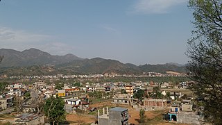
Beni is a municipality and the district headquarters of Myagdi District in Gandaki Province, Nepal. Municipality was announced by merging the then Ratnechaur, Jyamrukot, Arthunge, Pulachaur, Singa village development committees since 18 May 2014.

Vyas (Byas), is a municipality of Tanahun District located in Gandaki Province in Nepal and incorporates the village Damauli, the district headquarters, for which the municipality is also often referred to as Damauli. The municipality was established by merging the former Village development committee Damauli with several of its neighbors, the most recent merger being the one with Pokhari Bhanjyang in 2014. It lies on the bank of Madi Khola.
Rupakot is a village development committee in Tanahu District in Gandaki Province of central Nepal. At the time of the 1991 Nepal census it had a population of 4765 people living in 937 individual households. The VDC has been merged with existing Bhanu village development committees(VDCs), Barbhanjyang village development committees (VDCs) Tanahunsur Village Development Committee, Purkot VDC, Mirlung VDC, Satiswara VDC, Risti VDC, Basantapur VDC and Chok Chisapani VDC on 19 September 2015 to form Bhanu Municipality.
Shuklagandaki is a municipality located in Tanahu District of Gandaki Province in the Western Development Region, Nepal. The municipality was formed on 18 May 2014. It was formed by merging three Village Development Committees: Dhorphirdi, Dulegaunda and Khairenitar. And further more Thaprek, Raipur and Phirphire VDC are merged on 5 March 2017.
Rapti Municipality is a municipality which lies in Eastern part of Chitwan district in Bagmati Province of Nepal. It was formed as municipality in 2015 by merging five existing village development committees, Birendranagar VDC, Bhandara VDC, Piple VDC, Lothar VDC and Korak VDC. Total area of this municipality is 99.40 and population of this municipality according to 2068 BS census is 46510.
Rupa Rural Municipality (Rupa Gaupalika) (Nepali: रुपा गाउँपालिका) is a Gaunpalika in Kaski District in Gandaki Province of Nepal. On 12 March 2017, the government of Nepal implemented a new local administrative structure, in which VDCs have been replaced with municipal and Village Councils. Rupa is one of these 753 local units.
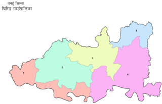
Ghiring Rural Municipality (Ghiring Gaupalika) (Nepali: घिरिङ्ग गाउँपालिका) is a Gaunpalika in Tanahaun District in Gandaki Province of Nepal. On 12 March 2017, the government of Nepal implemented a new local administrative structure, in which VDCs have been replaced with municipal and Village Councils. Ghiring is one of these 753 local units.
Myagde Rural Municipality (Myagde Gaupalika) (Nepali: म्याग्दे गाउँपालिका) is a Gaunpalika in Tanahaun District in Gandaki Province of Nepal. On 12 March 2017, the government of Nepal implemented a new local administrative structure, in which VDCs have been replaced with municipal and Village Councils. Myagde is one of these 753 local units.
Siranchok Rural Municipality is a Gaunpalika in Gorkha District in Gandaki Province of Nepal. On 12 March 2017, the government of Nepal implemented a new local administrative structure, with the implementation of the new local administrative structure, VDCs have been replaced with municipal and Village Councils. Siranchowk is one of these 753 local units.
Ajirkot Rural Municipality is a Gaunpalika in Gorkha District in Gandaki Province of Nepal. On 12 March 2017, the government of Nepal implemented a new local administrative structure, with the implementation of the new local administrative structure, VDCs have been replaced with municipal and Village Councils. Ajirkot is one of these 753 local units.
Bhimsen Thapa Municipality is a Rural Municipality aka Gaunpalika in Gorkha District in Gandaki Province of Nepal. On 12 March 2017, the government of Nepal implemented a new local administrative structure, with the implementation of the new local administrative structure, VDCs have been replaced with Urban Municipality and Rural Municipality. Bhimsen Thapa is one of these 753 local units. It represents - Masel VDC for ward number 1, Tandrang VDC for ward number 2 and 3, Dhawa VDC for ward number 4, Baguwa VDC for ward number 5, Ashrang VDC for ward number 6, and Borlang VDC for ward number 7 and 8.

Sahid Lakhan Rural Municipality is a Gaunpalika in Gorkha District in Gandaki Province of Nepal. In 12 March 2017, the government of Nepal implemented a new local administrative structure, with the implementation of the new local administrative structure, VDCs have been replaced with municipal and Village Councils. Sahid Lakhan is one of these 753 local units.
Arughat Rural Municipality is a Gaunpalika in Gorkha District in Gandaki Province of Nepal. It is divided into 10 wards. On 12 March 2017, the government of Nepal implemented a new local administrative structure, with the implementation of the new local administrative structure, VDCs have been replaced with municipal and Village Councils. Arughat is one of these 753 local units.
Gandaki Rural Municipality is a Gaunpalika in Gorkha District in Gandaki Province of Nepal. On 12 March 2017, the government of Nepal implemented a new local administrative structure, with the implementation of the new local administrative structure, VDCs have been replaced with municipal and Village Councils. Gandaki is one of these 753 local units.
Mangala Rural Municipality is a Gaunpalika in Myagdi District in Gandaki Province of Nepal. On 12 March 2017, the government of Nepal implemented a new local administrative structure, with the implementation of the new local administrative structure, VDCs have been replaced with municipal and Village Councils. Mangala is one of these 753 local units.
Malika Rural Municipality is a Gaunpalika in Myagdi District in Gandaki Province of Nepal. On 12 March 2017, the government of Nepal implemented a new local administrative structure, with the implementation of the new local administrative structure, VDCs have been replaced with municipal and Village Councils. Malika is one of these 753 local units.
Raghuganga, officially Raghuganga Rural Municipality is a Gaunpalika with around 16,377 inhabitants living in 2021. It is located in Myagdi District, Gandaki Province of Nepal. On 12 March 2017, the government of Nepal implemented a new local administrative structure, with the implementation of the new local administrative structure, VDCs have been replaced with municipal and Village Councils. Raghuganga is one of these 753 local units.
Devghat is a Rural municipality located within the Tanahun District of the Gandaki Province of Nepal. The rural municipality spans 159 square kilometres (61 sq mi) of area, with a total population of 16,131 according to a 2011 Nepal census.


