Bigfoot, Texas

Last updated

Bigfoot, Texas
BigfootMuseum (1 of 1).jpg
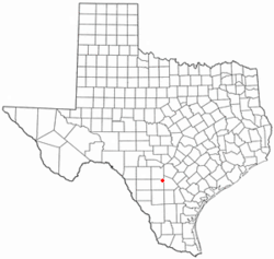
TXMap-doton-Bigfoot.PNG
Location of Bigfoot, Texas
Frio County Bigfoot.svg
Coordinates: 29°3′19″N98°50′49″W / 29.05528°N 98.84694°W / 29.05528; -98.84694
Country United States
State Texas
County Frio
Area
  Total23.92 sq mi (61.96 km2)
  Land23.91 sq mi (61.92 km2)
  Water0.02 sq mi (0.04 km2)
Elevation
650 ft (198 m)
Population
 (2020)
  Total480
  Density20/sq mi (7.7/km2)
Time zone UTC-6 (Central (CST))
  Summer (DST) UTC-5 (CDT)
ZIP code
78005
Area code 830
FIPS code 48-08164 [1]
GNIS feature ID1352186 [2]

Bigfoot is an unincorporated community and census-designated place (CDP) in Frio County, Texas, United States. The population was 450 at the 2010 census, [3] up from 304 at the 2000 census.

Contents

History

The first settlement at Bigfoot was made in the 1860s, but the community was called "Connally's Store" until the post office was established in 1883. [4] The present name is in honor of Texas Ranger William A. A. "Bigfoot" Wallace, [5] a former resident of the town. [6]

Geography

Bigfoot is located in the northeast corner of Frio County at 29°3′19″N98°50′49″W / 29.05528°N 98.84694°W / 29.05528; -98.84694 (29.055333, -98.847011). [7] It is bordered to the north by Medina County and to the east by Atascosa County. Texas State Highway 173 passes through the northeastern part of the CDP, leading northwest 7 miles (11 km) to Devine and southeast 20 miles (32 km) to Jourdanton. Downtown San Antonio is 41 miles (66 km) to the north, and Pearsall, the Frio County seat, is 21 miles (34 km) to the southwest.

According to the United States Census Bureau, the Bigfoot CDP has a total area of 23.9 square miles (62.0 km2), of which 0.02 square miles (0.04 km2), or 0.06%, is water. [3]

Demographics

Historical population
CensusPop.Note
2000 304
2010 45048.0%
2020 4806.7%
US Decennial Census [7]
2020 Census [8]

As of the census [1] of 2000, there were 304 people, 110 households, and 91 families residing in the CDP. The population density was 12.7 people per square mile (4.9/km2). There were 127 housing units at an average density of 5.3/sq mi (2.1/km2). The racial makeup of the CDP was 81.58% White, 16.12% from other races, and 2.30% from two or more races. Hispanic or Latino of any race were 44.74% of the population.

There were 110 households, out of which 31.8% had children under the age of 18 living with them, 66.4% were married couples living together, 12.7% had a female householder with no husband present, and 16.4% were non-families. 14.5% of all households were made up of individuals, and 9.1% had someone living alone who was 65 years of age or older. The average household size was 2.76 and the average family size was 3.01.

In the CDP, the population was spread out, with 25.0% under the age of 18, 7.6% from 18 to 24, 25.7% from 25 to 44, 29.3% from 45 to 64, and 12.5% who were 65 years of age or older. The median age was 39 years. For every 100 females, there were 105.4 males. For every 100 females age 18 and over, there were 101.8 males.

The median income for a household in the CDP was $19,375, and the median income for a family was $17,083. Males had a median income of $22,917 versus $28,750 for females. The per capita income for the CDP was $14,250. About 23.7% of families and 29.1% of the population were below the poverty line, including 38.2% of those under the age of eighteen and 27.5% of those 65 or over, the area code here is 830.

Education

Bigfoot is served by the Devine Independent School District.

Related Research Articles

<span class="mw-page-title-main">Frio County, Texas</span> County in Texas, United States

Frio County is a county located in the U.S. state of Texas. As of the 2020 census, its population was 18,385. The county seat is Pearsall. The county was created in 1858 and later organized in 1871. Frio is named for the Frio River, whose name is Spanish for "cold".

<span class="mw-page-title-main">Meadowood, Pennsylvania</span> Census-designated place in Pennsylvania, United States

Meadowood is a census-designated place (CDP) in Butler County, Pennsylvania, United States. The population was 2,693 at the 2010 census.

<span class="mw-page-title-main">Encino, Texas</span> Census-designated place in Texas, United States

Encino is a census-designated place (CDP) in Brooks County, Texas, United States. It is 18 miles (29 km) south of the county seat of Falfurrias. The population was 109 at the 2020 census. It is the site of a United States Border Patrol interior checkpoint.

<span class="mw-page-title-main">Encantada-Ranchito-El Calaboz, Texas</span> Census-designated place in Texas, United States

Encantada-Ranchito-El Calaboz, also known as El Calaboz Rancheria in the San Pedro de Carricitos Land Grant, is a census-designated place (CDP) in Cameron County, Texas, United States. The population was 1,981 at the 2020 census. It is part of the Brownsville–Harlingen Metropolitan Statistical Area.

<span class="mw-page-title-main">Cumings, Texas</span> Census-designated place in Texas, United States

Cumings is an unincorporated community and census-designated place (CDP) in Fort Bend County, Texas, United States. The population was 2,207 at the 2020 census, significantly up from 981 at the 2010 census.

<span class="mw-page-title-main">Hilltop, Texas</span> Census-designated place in Texas, United States

Hilltop is an unincorporated community and census-designated place (CDP) in Frio County, Texas, United States. Its population was 356 at the 2020 census.

<span class="mw-page-title-main">Moore, Texas</span> Census-designated place in Texas, United States

Moore is an unincorporated community and census-designated place (CDP) in Frio County, Texas, United States. Its population was 610 at the 2020 census.

<span class="mw-page-title-main">North Pearsall, Texas</span> Census-designated place in Frio County, Texas, United States

North Pearsall is a census-designated place (CDP) in Frio County, Texas, United States. The population was 739 at the 2020 census.

West Pearsall was a census-designated place (CDP) in Frio County, Texas, United States. The population was 349 at the 2000 census.

<span class="mw-page-title-main">McQueeney, Texas</span> Census-designated place in Texas, United States

McQueeney is an unincorporated community and census-designated place (CDP) in Guadalupe County, Texas, United States. The population was 2,397 at the 2020 census. It is part of the San Antonio Metropolitan Statistical Area.

Northcliffe is a former census-designated place (CDP) in Guadalupe County, Texas, United States. The population was 1,819 at the 2000 census. The area is now part of the city of Schertz and did not have its population recorded separately at the 2010 census. It is part of the San Antonio Metropolitan Statistical Area.

<span class="mw-page-title-main">Zuehl, Texas</span> Census-designated place in Texas, United States

Zuehl is an unincorporated area and census-designated place in western Guadalupe County, Texas, United States. It is part of the San Antonio Metropolitan Statistical Area. Located on Cibolo Creek, it lies 13 miles (21 km) southwest of Seguin. The population was 399 at the 2020 census.

<span class="mw-page-title-main">South Alamo, Texas</span> Census-designated place in Texas

South Alamo is a census-designated place (CDP) in Hidalgo County, Texas, United States. The area is known locally as "Little Mex (Mexico)". The population was 3,414 at the 2020 United States Census. It is part of the McAllen–Edinburg–Mission Metropolitan Statistical Area.

<span class="mw-page-title-main">Fowlerton, Texas</span> Census-designated place in Texas, United States

Fowlerton is a census-designated place (CDP) in La Salle County, Texas, United States. Its population was 55 at the 2010 census.

<span class="mw-page-title-main">Devine, Texas</span> City in Texas, United States

Devine is a city in Medina County, Texas, United States. The population was 4,324 at the 2020 census. It is part of the San Antonio Metropolitan Statistical Area.

<span class="mw-page-title-main">El Refugio, Texas</span> CDP in Texas, United States

El Refugio is a census-designated place (CDP) in Starr County, Texas, United States. The population was 407 at the 2020 census. El Refugio gained area in the 2010 census.

<span class="mw-page-title-main">La Puerta, Texas</span> CDP in Texas, United States

La Puerta is a census-designated place (CDP) in Starr County, Texas, United States. The population was 638 at the 2020 census, an increase from the figure of 632 tabulated in 2010 census.

<span class="mw-page-title-main">La Victoria, Texas</span> CDP in Texas, United States

La Victoria is a census-designated place (CDP) in Starr County, Texas, United States. La Victoria underwent some changes prior to the 2010 census. It gained area, had portions taken to form new CDPs, and lost additional area. Only a small part of 2010 La Victoria CDP was within the 2000 La Victoria CDP. The population was only 171 at the 2010 census, a decline from the figure of 1,683 tabulated at the 2000 census.

<span class="mw-page-title-main">Horseshoe Bay, Texas</span> City in Texas, United States

Horseshoe Bay is a city in Llano and Burnet counties in the U.S. state of Texas.

<span class="mw-page-title-main">Amenia (CDP), New York</span> Hamlet in the state of New York, United States

Amenia is a hamlet and census-designated place (CDP) in Dutchess County, New York, United States. The population was 725 at the 2020 census. It is part of the Poughkeepsie–Newburgh–Middletown, NY Metropolitan Statistical Area as well as the larger New York–Newark–Bridgeport, NY-NJ-CT-PA Combined Statistical Area.

References

  1. 1 2 "U.S. Census website". United States Census Bureau . Retrieved January 31, 2008.
  2. "US Board on Geographic Names". United States Geological Survey. October 25, 2007. Retrieved January 31, 2008.
  3. 1 2 "Geographic Identifiers: 2010 Demographic Profile Data (G001): Bigfoot CDP, Texas". U.S. Census Bureau, American Factfinder. Retrieved September 7, 2016.[ dead link ]
  4. Bigfoot from the Handbook of Texas Online
  5. Hubbard, George (November 30, 2002). Humor & Drama of Early Texas. Taylor Trade Publications. p. 215. ISBN   978-1-55622-843-8.
  6. Tarpley, Fred (July 5, 2010). 1001 Texas Place Names. University of Texas Press. p. 25. ISBN   978-0-292-78693-6.
  7. 1 2 "US Gazetteer files: 2010, 2000, and 1990". United States Census Bureau. February 12, 2011. Retrieved April 23, 2011.
  8. "Census Bureau profile: Bigfoot, Texas". United States Census Bureau. May 2023. Retrieved June 20, 2024.