Moore, Texas

Last updated

Moore, Texas
TXMap-doton-Moore.PNG
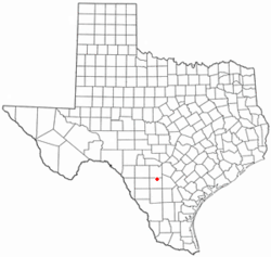
Location of Moore, Texas
Frio County Moore.svg
Coordinates: 29°3′56″N99°0′48″W / 29.06556°N 99.01333°W / 29.06556; -99.01333
Country United States
State Texas
County Frio
Area
  Total6.1 sq mi (15.8 km2)
  Land6.1 sq mi (15.8 km2)
  Water0.0 sq mi (0.0 km2)
Elevation
663 ft (202 m)
Population
 (2020) [1]
  Total610
  Density100/sq mi (39/km2)
Time zone UTC-6 (Central (CST))
  Summer (DST) UTC-5 (CDT)
ZIP code
78057
Area code 830
FIPS code 48-49224 [2]
GNIS feature ID1363092 [3]

Moore is an unincorporated community and census-designated place (CDP) in Frio County, Texas, United States. Its population was 610 at the 2020 census.

Contents

Geography

Moore is located in northeastern Frio County at 29°03′56″N99°00′48″W / 29.065636°N 99.013345°W / 29.065636; -99.013345 (29.065636, -99.013345). [4] Interstate 35 passes through the community, with access from Exit 114. I-35 leads northeast 44 mi (71 km) to downtown San Antonio and southwest 13 mi (21 km) to Pearsall, the Frio County seat.

According to the United States Census Bureau, the CDP as drawn in 2010 has a total area of 6.1 sq mi (15.8 km2), [5] down from an area of 31.2 square miles (81 km2) at the 2000 census. All of the CDP area is land.

Demographics

Historical population
CensusPop.Note
2000 644
2010 475−26.2%
2020 61028.4%
U.S. Decennial Census [6]
1850–1900 [7] 1910 [8]
1920 [9] 1930 [10] 1940 [11]
1950 [12] 1960 [13] 1970 [14]
1980 [15] 1990 [16] 2000 [17]
2010 [18] 2020 Census [1]

As of the census of 2020, 279 people lived in the Moore CDP. [19] The population density was 20.6 people per square mile (8.0/km2). The 283 housing units averaged 9.1/sq mi (3.5/km2). The racial makeup of the CDP was 85.09% White, 0.47% African American, 1.40% Native American, 0.31% Pacific Islander, 10.09% from other races, and 2.64% from two or more races. Hispanics or Latinos of any race were 46.27% of the population.

Of the 248 households, 29.8% had children under the age of 18 living with them, 55.6% were married couples living together, 10.9% had a female householder with no husband present, and 26.6% were not families. About 23.4% of all households were made up of individuals, and 9.7% had someone living alone who was 65 years of age or older. The average household size was 2.56, and the average family size was 3.02.

In the CDP, the age distribution was 25.6% under 18, 4.5% from 18 to 24, 25.8% from 25 to 44, 27.0% from 45 to 64, and 17.1% who were 65 or older. The median age was 40 years. For every 100 females, there were 107.1 males. For every 100 females age 18 and over, there were 100.4 males.

The median income for a household in the CDP was $39,063, and for a family was $40,774. Males had a median income of $24,531 versus $28,281 for females. The per capita income for the CDP was $15,975. About 9.9% of families and 15.4% of the population were below the poverty line, including 19.2% of those under age 18 and 12.2% of those age 65 or over.
Education

Moore is served by the Pearsall Independent School District.

Related Research Articles

<span class="mw-page-title-main">Frio County, Texas</span> County in Texas, United States

Frio County is a county located in the U.S. state of Texas. As of the 2020 census, its population was 18,385. The county seat is Pearsall. The county was created in 1858 and later organized in 1871. Frio is named for the Frio River, whose name is Spanish for "cold".

<span class="mw-page-title-main">Cantu Addition, Texas</span> Census-designated place in Texas, United States

Cantu Addition is a census-designated place (CDP) in Brooks County, Texas, United States. Its population was 191 at the 2020 census.

<span class="mw-page-title-main">Cameron Park, Texas</span> CDP in Texas, United States

Cameron Park is a census-designated place (CDP) in Cameron County, Texas, United States. The population was 6,099 at the 2020 census. It is part of the Brownsville–Harlingen Metropolitan Statistical Area.

<span class="mw-page-title-main">Brundage, Texas</span> Census-designated place in Texas, United States

Brundage is an unincorporated community and census-designated place (CDP) in Dimmit County, Texas, United States. The population was 12 at the 2020 census.

<span class="mw-page-title-main">Bigfoot, Texas</span> Census-designated place and Unincorporated Community in Texas, United States

Bigfoot is an unincorporated community and census-designated place (CDP) in Frio County, Texas, United States. The population was 450 at the 2010 census, up from 304 at the 2000 census.

<span class="mw-page-title-main">Hilltop, Texas</span> Census-designated place in Texas, United States

Hilltop is an unincorporated community and census-designated place (CDP) in Frio County, Texas, United States. Its population was 356 at the 2020 census.

<span class="mw-page-title-main">North Pearsall, Texas</span> Census-designated place in Frio County, Texas, United States

North Pearsall is a census-designated place (CDP) in Frio County, Texas, United States. The population was 739 at the 2020 census.

<span class="mw-page-title-main">Pearsall, Texas</span> City in Texas, United States

Pearsall is a city in and the county seat of Frio County, Texas, United States. The population was 7,325 at the 2020 census, down from 9,146 at the 2010 census.

West Pearsall was a census-designated place (CDP) in Frio County, Texas, United States. The population was 349 at the 2000 census.

<span class="mw-page-title-main">Fronton, Texas</span> CDP in Texas, United States

Fronton is a census-designated place (CDP) in Starr County, Texas, United States, bordering the Mexican state of Tamaulipas, close to Ciudad Miguel Alemán. The population was 172 at the 2020 census, a decline from the figure of 180 tabulated in 2010.

<span class="mw-page-title-main">La Victoria, Texas</span> CDP in Texas, United States

La Victoria is a census-designated place (CDP) in Starr County, Texas, United States. La Victoria underwent some changes prior to the 2010 census. It gained area, had portions taken to form new CDPs, and lost additional area. Only a small part of 2010 La Victoria CDP was within the 2000 La Victoria CDP. The population was only 171 at the 2010 census, a decline from the figure of 1,683 tabulated at the 2000 census.

<span class="mw-page-title-main">North Escobares, Texas</span> CDP in Texas, United States

North Escobares is a census-designated place (CDP) in Starr County, Texas, United States. The population was 118 at the 2010 census, a decline from the figure of 1,692 tablulated in 2000.

<span class="mw-page-title-main">Elbert, Texas</span> CDP in Texas, United States

Elbert is a census-designated place (CDP) in Throckmorton County, Texas, United States. The population was 29 at the 2020 census.

Laredo Ranchettes is a census-designated place (CDP) in Webb County, Texas, United States. The population was 22 at the 2010 census.

Ranchitos Las Lomas is a census-designated place (CDP) in Webb County, Texas, United States. The population was 167 at the 2020 census. Las Lomas means "the hills" in Spanish.

<span class="mw-page-title-main">Ranchos Penitas West, Texas</span> CDP in Texas, United States

Ranchos Penitas West is a census-designated place (CDP) in Webb County, Texas, United States. The population was 466 at the 2020 census.

<span class="mw-page-title-main">Falcon Lake Estates, Texas</span> CDP in Texas, United States

Falcon Lake Estates is a census-designated place (CDP) in Zapata County, Texas, United States. The population was 962 at the 2020 census.

Morales-Sanchez is a census-designated place (CDP) in Zapata County, Texas, United States. The population was 84 at the 2010 census.

<span class="mw-page-title-main">Batesville, Texas</span> CDP in Texas, United States

Batesville is a census-designated place (CDP) in Zavala County, Texas, United States. The population was 1,068 at the 2010 census.

<span class="mw-page-title-main">Chula Vista, Zavala County, Texas</span> CDP in Texas, United States

Chula Vista is a census-designated place (CDP) in Zavala County, Texas, United States. The population was 307 at the 2020 census. Prior to the 2010 census, the CDP was known as Chula Vista-River Spur.

References

  1. 1 2 "Census Bureau profile: Moore, Texas". United States Census Bureau. May 2023. Retrieved June 4, 2024.
  2. "U.S. Census website". United States Census Bureau . Retrieved January 31, 2008.
  3. "US Board on Geographic Names". United States Geological Survey. October 25, 2007. Retrieved January 31, 2008.
  4. "US Gazetteer files: 2010, 2000, and 1990". United States Census Bureau. February 12, 2011. Retrieved April 23, 2011.
  5. "Geographic Identifiers: 2010 Demographic Profile Data (G001): Moore CDP, Texas". U.S. Census Bureau, American Factfinder. Retrieved September 7, 2016.[ dead link ]
  6. "Decennial Census by Decade". United States Census Bureau .
  7. "1900 Census of Population - Population of Texas By Counties And Minor Civil Divisions" (PDF). United States Census Bureau .
  8. "1910 Census of Population - Supplement for Texas" (PDF). United States Census Bureau .
  9. "1920 Census of Population - Number of Inhabitants - Texas" (PDF). United States Census Bureau .
  10. "1930 Census of Population - Number of Inhabitants - Texas" (PDF). United States Census Bureau .
  11. "1940 Census of Population - Number of Inhabitants - Texas" (PDF). United States Census Bureau .
  12. "1950 Census of Population - Number of Inhabitants - Texas" (PDF). United States Census Bureau .
  13. "1960 Census of Population - Number of Inhabitants - Texas" (PDF). United States Census Bureau .
  14. "1970 Census of Population - Number of Inhabitants - Texas" (PDF). United States Census Bureau .
  15. "1980 Census of Population - Number of Inhabitants - Texas" (PDF). United States Census Bureau .
  16. "1990 Census of Population - Population and Housing Unit Counts - Texas" (PDF). United States Census Bureau .
  17. "2000 Census of Population - Population and Housing Unit Counts - Texas" (PDF). United States Census Bureau .
  18. "2010 Census of Population - Population and Housing Unit Counts - Texas" (PDF). United States Census Bureau .
  19. "Moore - Place Explorer - Data Commons". datacommons.org. Retrieved March 16, 2023.