Middlesex County is a county located in the Commonwealth of Massachusetts, United States. As of the 2020 census, the population was 1,632,002, making it the most populous county in both Massachusetts and New England and the 22nd most populous county in the United States. Middlesex County is one of two U.S. counties to be amongst the top 25 counties with the highest household income and the 25 most populated counties. It is included in the Census Bureau's Boston–Cambridge–Newton, MA–NH Metropolitan Statistical Area. As part of the 2020 United States census, the Commonwealth's mean center of population for that year was geo-centered in Middlesex County, in the town of Natick.

Acton is a town in Middlesex County, Massachusetts, United States, approximately 21 miles (34 km) west-northwest of Boston along Massachusetts Route 2 west of Concord and about ten miles (16 km) southwest of Lowell. The population was 24,021 in April 2020, according to the United States Census Bureau. It is bordered by Westford and Littleton to the north, Concord and Carlisle to the east, Stow, Maynard, and Sudbury to the south and Boxborough to the west. Acton became an incorporated town in 1735. The town employs the Open Town Meeting form of government with a town manager and an elected, five-member select board. Acton was named the 11th Best Place To Live among small towns in the country by Money Magazine in 2015, and the 16th best in 2009 and in 2011. The local high school, Acton-Boxborough Regional High School, was named a Blue Ribbon School by the U.S. Department of Education in 2009.

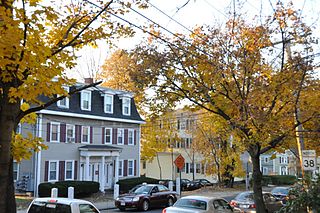
Bedford is a town in Middlesex County, Massachusetts, United States. The population of Bedford was 14,161 at the 2022 United States census.

Billerica is a town in Middlesex County, Massachusetts, United States. The population was 42,119 according to the 2020 census. It takes its name from the town of Billericay in Essex, England.

Lowell is a city in Massachusetts, United States. Alongside Cambridge, it is one of two traditional seats of Middlesex County. With an estimated population of 115,554 in 2020, it was the fifth most populous city in Massachusetts as of the last census, and the third most populous in the Boston metropolitan statistical area. The city is also part of a smaller Massachusetts statistical area, called Greater Lowell, and of New England's Merrimack Valley region.
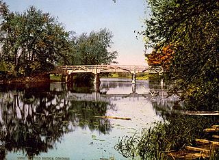
The Concord River is a 16.3-mile-long (26.2 km) tributary of the Merrimack River in eastern Massachusetts, United States. The river drains a small rural and suburban region northwest of Boston. As one of the most notable small rivers in U.S. history, it was the scene of an important early battle of the American Revolutionary War and was the subject of a 19th-century book by Henry David Thoreau.

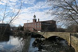
Thomas Talbot was an American textile mill owner and politician from Massachusetts, United States. Talbot ran a major textile business, involving chemical dyeworks and the weaving of fabric, in Billerica that was a major local employer. As a Republican, he served in the state legislature, on the Massachusetts Governor's Council, and as the 29th lieutenant governor before serving for one partial term as acting governor of Massachusetts, and later for one full term as the 31st governor.

The Middlesex Canal was a 27-mile (44-kilometer) barge canal connecting the Merrimack River with the port of Boston. When operational it was 30 feet wide, and 3 feet deep, with 20 locks, each 80 feet long and between 10 and 11 feet wide. It also had eight aqueducts.

Middlesex Community College is a public community college with two campuses in Massachusetts, one in Lowell and the other in Bedford.

The Boston Manufacturing Company was a business that operated one of the first factories in America. It was organized in 1813 by Francis Cabot Lowell, a wealthy Boston merchant, in partnership with a group of investors later known as The Boston Associates, for the manufacture of cotton textiles. It built the first integrated spinning and weaving factory in the world at Waltham, Massachusetts, using water power. They used plans for a power loom that he smuggled out of England as well as trade secrets from the earlier horse-powered Beverly Cotton Manufactory, of Beverly, Massachusetts, of 1788. This was the largest factory in the U.S., with a workforce of about 300. It was a very efficient, highly profitable mill that, with the aid of the Tariff of 1816, competed effectively with British textiles at a time when many smaller operations were being forced out of business. While the Rhode Island System that followed was famously employed by Samuel Slater, the Boston Associates improved upon it with the "Waltham System". The idea was successfully copied at Lowell, Massachusetts, and elsewhere in New England. Many rural towns now had their own textile mills.

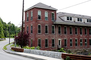
North Billerica is an unincorporated village of the town of Billerica, Massachusetts, United States, one of the nine sections (hamlets) that make up the Town of Billerica. It is the home to Faulkner and Talbot mills and the North Billerica Train Depot. The Middlesex Canal was built through the village in 1783 and the Boston and Lowell Railroad was put through in the 1840s.

The Middlesex Turnpike was an early turnpike between Cambridge and Tyngsborough, Massachusetts and the New Hampshire border, where it connected with the Amherst Turnpike and thence Nashua and Claremont, New Hampshire.

The Cheney Brothers Historic District was a center of the silk industry in Manchester, Connecticut, in the late 19th and early 20th century. The 175-acre (71 ha) district includes over 275 mill buildings, workers houses, churches, schools and Cheney family mansions. These structures represent the well-preserved company town of the Cheney Brothers silk manufacturing company, the first America-based silk company to properly raise and process silkworms, and to develop the difficult techniques of spinning and weaving silk. The area was declared a National Historic Landmark in 1978.

The Ware Millyard Historic District encompasses a 19th-century mill complex and industrial mill village in the town of Ware, Massachusetts. It is roughly bounded by South Street, the Ware River, Upper Dam Complex, Park Street, Otis Avenue and Church Street. The area includes surviving mill buildings, the oldest of which date to the 1840s, and a collection of tenement-style housing built for the millworkers, built between 1845 and the 1880s.

The Springfield Street Historic District is a predominantly residential historic district south of the downtown area of Chicopee, Massachusetts. It encompasses a significant number of Queen Anne style houses built in the second half of the 19th century by wealthy residents of Chicopee, as well as housing for skilled workers at the nearby textile mills. It is centered where Springfield Street and Fairview Avenue meet. The district was listed on the National Register of Historic Places in 1991.

The Bedford Center Historic District encompasses the historic heart of the town of Bedford, Massachusetts. It extends along Great Road between Bacon and Concord Roads, and includes primarily residential areas on adjacent side streets. The area includes the town's main civic buildings, its first cemetery, and a diverse array of residential architecture spanning more than two centuries. The district was listed on the National Register of Historic Places in 1977; its boundaries were adjusted in 2014 and its period of significance extended.
The Brookside Historic District of Westford, Massachusetts encompasses surviving elements of the 19th century Brookside mill village, the smallest of the town's three 19th-century industrial villages. Developed between about 1860 and 1904, it includes surviving mill buildings and a variety of mill-related worker housing. The district was listed on the National Register of Historic Places in 2003.

The Saxonville Historic District of Framingham, Massachusetts, encompasses a historic 19th century mill village at the heart of Saxonville. The district is centered on the mill complex at the junction of Water, Central, Elm, and Concord Streets, radiating north on Elm Street and west on Water Street. The extant mill brick and concrete buildings were built after fires destroyed older mill buildings in the 1880s by the Roxbury Carpet Company, whose owner, Michael Simpson, had successfully orchestrated the commercial production of carpets in a single facility. The district includes mill worker housing, some of which dates to the 1820s, as well as private residential development from the period, and a cluster of commercial and civic buildings adjacent to the mill complex.
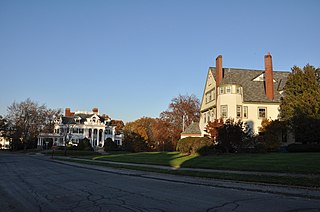
The Belvidere Hill Historic District encompasses a residential area on the east side of Lowell, Massachusetts known for its fine 19th-century houses. The area, roughly bounded by Wyman, Belmont, Fairview, and Nesmith Streets, was developed beginning in the 1850s, and was one of the finest neighborhoods in the city, home to many of its business and civic leaders. It was listed on the National Register of Historic Places in 1995.
The Washington Square Historic District of Lowell, Massachusetts encompasses a historic subdivision laid out in 1832. The focal point of the subdivision is Kittridge Park, which lies on the eastern side of the district and was an original part of the subdivision plan developed by the Nesmith Brothers. It was the first significant residential subdivision in the city aimed at a wealthier clientele, and was designed by landscape architect Alexander Wadsworth. The district was added to the National Register of Historic Places in 1982, and expanded slightly in 1999.