
Bedale, is a market town and civil parish in North Yorkshire, England. Historically part of the North Riding of Yorkshire, it is 34 miles (55 km) north of Leeds, 26 miles (42 km) south-west of Middlesbrough and 7 miles (11 km) south-west of the county town of Northallerton. It was originally in Richmondshire and listed in Domesday Book as part of Catterick wapentake, which was also known as Hangshire ; it was split again and Bedale remained in East Hang. Bedale Beck is a tributary of the River Swale, which forms one of the Yorkshire Dales, with its predominance of agriculture and its related small traditional trades, although tourism is increasingly important.

Appleton Wiske is a small village and civil parish that sits between Northallerton and Yarm in the Vale of York, a flat tract of land that runs between the North Yorkshire Moors to the east, the Yorkshire Dales to the west and the River Tees to the north.

Arrathorne is a hamlet and civil parish in the former Richmondshire district of North Yorkshire, England. The settlement is 6 miles (9 km) south of Richmond, 6 miles (9 km) north-west of Bedale and 6 miles (9 km) east of Leyburn. The name has been recorded variously as Ergthorn, Erchethorn, Erghethorn, Erethorn and Arrowthorne. It means The Thornbush by the Shieling. Historically, the hamlet was in the Parish of Patrick Brompton in the Wapentake of Hang East.
Burneston is a village and civil parish in North Yorkshire, England. According to the 2001 Census it had a population of 244, increasing to 311 at the 2011 Census. The village is close to the A1(M) road and is about 4 miles (6 km) south-east of Bedale.
Thirn is a village and civil parish in North Yorkshire, England. It is situated close to the River Ure, about 3 miles (5 km) south-west of Bedale.

Pickhill is a village in North Yorkshire, England, 6 miles (10 km) west of Thirsk. It is a part of the civil parish of Pickhill with Roxby.

Leeming Bar is a village in the civil parish of Aiskew and Leeming Bar, in North Yorkshire, England. The village lay on the original Great North Road before being bypassed. It is now home to a large industrial estate and the main operating site of the Wensleydale Railway. It is in the historic North Riding of Yorkshire.

North Stainley is a village in the Harrogate district of North Yorkshire, England 4 miles (6.4 km) north of Ripon. Historically part of the West Riding of Yorkshire, it is the closest settlement to the theme park Lightwater Valley which is 0.62 miles (1 km) to the south.
West Tanfield is a village and civil parish in the Hambleton district of North Yorkshire, England. The village is situated approximately six miles north of Ripon on the A6108, which goes from Ripon to Masham and Wensleydale. The parish includes the hamlets of Nosterfield, Thornborough and Binsoe.

Crakehall is a village and civil parish in the Hambleton District of North Yorkshire, England, approximately 2 miles (3 km) west of Bedale. More known as Thomas Barkers home grounds. The village lies along the route of the A684 and is split into two parts by Bedale Beck, a tributary of the River Swale. The population was estimated at 630 in 2015. The north-west part is known as Little Crakehall, and the south-east part as Great Crakehall. It is 8.3 miles (13.4 km) west-south-west of the county town of Northallerton.

Thornborough is a village in Hambleton District of North Yorkshire, England. It is about 7 miles (11 km) south of Bedale and 3 miles (5 km) west of the A1(M) motorway. Thornborough is in the West Tanfield parish. The Thornborough Henges ancient monuments are situated south and west of the village. The village lies just to the south of the B6267 road, which connects the A6055 in the east, with the A6108 road at Masham. The village is served by two buses a day in each direction between Ripon and Masham. When the Masham Branch of the North Eastern Railway was open, Tanfield station would have been the nearest railway station to Thornborough. Now the nearest railway station is at Thirsk.

Nosterfield is a hamlet within the civil parish of West Tanfield in the Hambleton district of North Yorkshire, England formerly used for quarrying.

Kirklington is a village in the English county of North Yorkshire close to the A1(M) motorway. Kirklington forms the major part of the civil parish of Kirklington-cum-Upsland.

Wildon Grange is a civil parish in the Hambleton district of North Yorkshire, England.

North Stainley with Sleningford is a civil parish in Harrogate district, North Yorkshire, England. The principal settlement and only village in the parish is North Stainley. The parish also includes the small settlements of Sleningford, North Lees and Sutton Grange. The Lightwater Valley theme park is also in the parish.

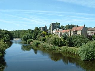
Mickley is a village in the Harrogate District of North Yorkshire, England. The village is on the south bank of the River Ure between Masham and West Tanfield.
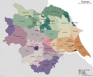
Hang East was a Wapentake (Hundred), which is an administrative division, in the historic county of the North Riding of Yorkshire. It was one of the smaller wapentakes by area and consisted of nine parishes and two towns; Bedale and Masham.
Hallikeld was a Wapentake (Hundred), which is an administrative division, in the historic county of the North Riding of Yorkshire. It was one of the smaller wapentakes by area and consisted of seven parishes.

Scawton is a village and former civil parish in North Yorkshire, England. The hamlet lies just east of Sutton Bank, north of the A170 road, and 5 miles (8 km) west of Helmsley, in the Hambleton Hills. The wider parish was the setting for the Battle of Old Byland, on Scawton Moor to the south. The road through the village used to link the two abbeys at Byland and Rievaulx, with the church, and possibly the village pub, being instigated by the monks for the use of travellers. In 1961 the parish had a population of 84.

Aiskew and Leeming Bar is a civil parish within the Bedale ward of North Yorkshire, England. The parish only has two settlements, but prior to the changes in the 19th century, the area it contains belonged to the parish of Bedale. At the 2011 Census, the population of the parish was 2,427.

