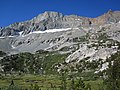
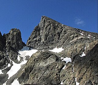
Mount Goode is a 13,085-foot-elevation mountain summit located on the crest of the Sierra Nevada mountain range in California, United States. It is situated on the shared boundary of Kings Canyon National Park with John Muir Wilderness, and along the common border of Fresno County with Inyo County. It is also approximately one mile west-northwest of Bishop Pass, one mile east-southeast of Mount Johnson, 1.23 miles (1.98 km) south of Hurd Peak, and 16 miles (26 km) west of the community of Big Pine.

Mount Thompson is a 13,494-foot-elevation mountain summit located on the crest of the Sierra Nevada mountain range in California, United States. It is situated on the shared boundary of Kings Canyon National Park with John Muir Wilderness, and along the common border of Fresno County with Inyo County. It is also 18 miles (29 km) west of the community of Big Pine, one mile northwest of Mount Gilbert, and three miles east of Mount Fiske, which is the nearest higher neighbor. Mount Thompson ranks as the 62nd-highest summit in California. This mountain's name commemorates Almon Harris Thompson (1839–1906). The first ascent of the peak was made by Clarence H. Rhudy and H. F. Katzenbach in the summer of 1909.

Langille Peak is a 12,018-foot-elevation (3,663-meter) mountain summit located west of the crest of the Sierra Nevada mountain range, in Fresno County of central California, United States. It is situated in northern Kings Canyon National Park, 19 miles (31 km) west-southwest of the community of Big Pine, 3 miles (4.8 km) south of Mount Thompson, 2.8 miles (4.5 km) southwest of Mount Goode, and 2.1 miles (3.4 km) east of Black Giant. Topographic relief is significant as the east aspect rises 3,100 feet above Le Conte Canyon in less than one mile. The approach to this remote peak is made via the John Muir Trail.

Mount Warlow is a 13,206-foot-elevation mountain summit located 1.5 miles (2.4 km) west of the crest of the Sierra Nevada mountain range, in Fresno County of northern California, United States. It is situated on the Goddard Divide in northern Kings Canyon National Park, 1.2 miles (1.9 km) north of Muir Pass, 0.69 miles (1.11 km) southeast of Mount Huxley, and 0.68 miles (1.09 km) southwest of Mount Fiske, which is the nearest higher neighbor. Mount Warlow ranks as the 108th highest summit in California. The approach to this remote peak is made via the John Muir Trail.

Picture Puzzle, also known as Picture Puzzle Peak, is a 13,297-foot-elevation mountain summit located one mile east of the crest of the Sierra Nevada mountain range in Inyo County of northern California, United States. It is situated in the Palisades area of the John Muir Wilderness, on land managed by Inyo National Forest. It is approximately 14.5 miles (23.3 km) west of the community of Big Pine, one mile north of Bishop Pass, 0.8 miles (1.3 km) northwest of Aperture Peak, 1.2 miles (1.9 km) north-northwest of Mount Agassiz, and 1.1 miles (1.8 km) south-southwest of parent Cloudripper. Picture Puzzle ranks as the 90th-highest summit in California, and the third-highest peak of the Inconsolable Range.

Crater Mountain is a 12,874-foot-elevation (3,924-meter) mountain summit located west of the crest of the Sierra Nevada mountain range, in Fresno County of northern California, United States. It is situated in eastern Kings Canyon National Park, 15.5 miles (24.9 km) northwest of the community of Independence, one mile immediately southwest of Pinchot Pass, and 1.3 miles (2.1 km) southeast of Mount Ickes, which is the nearest higher neighbor. Other nearby peaks include Mount Wynne, 1.5 miles (2.4 km) to the northeast, and Mount Cedric Wright, 2.2 miles (3.5 km) to the southeast. Crater Mountain ranks as the 186th highest summit in California. Topographic relief is significant as the west aspect rises 2,000 feet in less than one mile. The approach to this remote peak is made via the John Muir Trail which passes below the east aspect of the mountain. The first ascent of the summit was made July 19, 1922, by W. H. Ink, Meyers Butte, Frank Baxter, and Captain Wallace. This mountain has no crater as the name implies.

Emerald Peak is a 12,546-foot-elevation (3,824-meter) mountain summit located west of the crest of the Sierra Nevada mountain range, in Fresno County of central California, United States. It is situated in northern Kings Canyon National Park, southwest of Evolution Valley, and 2.3 miles (3.7 km) northwest of Mount McGee, the nearest higher neighbor. Other nearby peaks include The Hermit, 2.5 miles (4.0 km) to the east, and Peter Peak, 1.6 miles (2.6 km) to the southeast. Topographic relief is significant as the west aspect rises over 3,500 feet above Goddard Canyon in 1.5 mile. The John Muir Trail passes to the northeast, providing an approach.

Mount McGee is a 12,944-foot-elevation (3,945-meter) mountain summit located west of the crest of the Sierra Nevada mountain range, in Fresno County of central California, United States. It is situated in northern Kings Canyon National Park, 0.6 miles (0.97 km) southeast of Peter Peak, 2 miles (3.2 km) southwest of The Hermit, and 2.6 miles (4.2 km) north-northwest of Mount Goddard, the nearest higher neighbor. Topographic relief is significant as the west aspect rises 3,100 feet above Goddard Canyon in two miles. This geographical feature was named for William John McGee (1853–1912), well-known American geologist and anthropologist. This mountain's name has been officially adopted by the United States Board on Geographic Names. The first ascent of the summit was made in July 1923 by Roger N. Burnham, Robert E. Brownlee, Ralph H. Brandt, and Leonard Keeler.

Mount Henry is a 12,196-foot-elevation (3,717-meter) mountain summit located in the Sierra Nevada mountain range, in Fresno County of northern California, United States. It is situated on the Le Conte Divide, along the shared boundary of John Muir Wilderness and Kings Canyon National Park, and 3.7 miles (6.0 km) northwest of Emerald Peak, the nearest higher neighbor. Topographic relief is significant as the east aspect rises 3,800 feet above South Fork San Joaquin River in two miles. The John Muir Trail passes to the northeast, providing an approach option.

Mount Bago is an 11,870-foot-elevation (3,620-meter) mountain summit located west of the crest of the Sierra Nevada mountain range, in the southeast corner of Fresno County, in northern California. It is situated in Kings Canyon National Park, 14 miles (23 km) west of the community of Independence, 2.3 miles west of the Kearsarge Pinnacles, and 2.4 miles southwest of Mount Rixford. Topographic relief is significant as the south aspect rises 3,675 feet above Junction Meadow in one mile. The John Muir Trail passes to the northeast of this remote geographical feature. The first ascent of the summit was made July 11, 1896, by Joseph Nisbet LeConte and Wilson S. Gould.
Devils Crags is a 12,424-foot-elevation (3,787-meter) mountain summit located west of the crest of the Sierra Nevada mountain range, in Fresno County of central California, United States. This jagged line of 11 pinnacles is situated at the southern end of the Black Divide in northern Kings Canyon National Park, 1.88 miles (3.03 km) south of The Citadel, and one mile southeast of Wheel Mountain, which is the nearest higher neighbor. Devils Crags ranks as the 299th highest summit in California. Topographic relief is significant as it rises 4,200 feet above Le Conte Canyon in approximately two miles. An approach to this remote peak is made possible via the John Muir Trail which passes through Le Conte Canyon, below to the east. The class 5 Northwest Arête is considered one of the classic climbing routes in the Sierra Nevada.

Mount McDuffie is a 13,291-foot-elevation (4,051-meter) mountain summit located west of the crest of the Sierra Nevada mountain range, in Fresno County of central California, United States. This peak is situated in northern Kings Canyon National Park, 1.9 miles (3.1 km) northwest of The Citadel, and two miles south of Black Giant, which is the nearest higher neighbor. McDuffie ranks as the 93rd highest summit in California, and the second-highest point on Black Divide. Topographic relief is significant as it rises nearly 4,900 feet above Le Conte Canyon in approximately 2.5 miles. An approach to this remote peak is made possible via the John Muir Trail.

Mount Baldwin is a 12,614-foot-elevation (3,845-meter) mountain summit located in the Sierra Nevada mountain range in Mono County of northern California, United States. It is situated in the John Muir Wilderness on land managed by Inyo National Forest. It is four miles north of Red and White Mountain, and approximately 10.5 miles (16.9 km) southeast of the community of Mammoth Lakes. The nearest higher neighbor is Red Slate Mountain, 2 miles (3.2 km) to the south-southwest. Baldwin ranks as the 257th highest summit in California. Topographic relief is significant as the east aspect rises 3,775 feet above McGee Canyon in 1.5 mile. The first ascent of the summit was made July 2, 1928, by Norman Clyde, who is credited with 130 first ascents, most of which were in the Sierra Nevada.

Wheel Mountain is a 12,774-foot-elevation (3,894-meter) mountain summit located west of the crest of the Sierra Nevada mountain range, in Fresno County of central California, United States. This mountain is situated on the Black Divide in northern Kings Canyon National Park, one mile northwest of Devils Crags, and two miles south-southeast of Mount McDuffie, which is the nearest higher neighbor. Wheel Mountain ranks as the 216th-highest summit in California, and the fifth-highest on Black Divide. Topographic relief is significant as the west aspect rises 4,500 feet above Enchanted Gorge in approximately 1.5 mile, and the east aspect rises 4,500 feet above Le Conte Canyon in 2.5 miles. An approach to this remote peak is made possible via the John Muir Trail.

Mount Gilbert is a 13,106-foot (3,995 m) mountain located on the crest of the Sierra Nevada range in California, United States. It is situated on the shared boundary of Kings Canyon National Park and John Muir Wilderness, and along the common border of Fresno County and Inyo County. It is 18 miles (29 km) west of the community of Big Pine, 0.8 mile (1.3 km) northwest of Mount Johnson, and one mile (1.6 km) southeast of Mount Thompson, which is its nearest higher neighbor. Mount Gilbert ranks as the 127th-highest summit in California. Topographic relief is significant as the south aspect rises 3,900 feet (1,189 m) above LeConte Canyon in less than two miles, and the northern aspect rises 3,340 feet above South Lake in 2.5 miles.
Mount Johnson is a 12,871-foot-elevation mountain summit located on the crest of the Sierra Nevada mountain range in California, United States. It is situated on the boundary between Kings Canyon National Park and John Muir Wilderness, and along the county line between Fresno County and Inyo County. It is also 18 miles (29 km) west of the community of Big Pine, 0.9 miles (1.4 km) southeast of Mount Gilbert, and one mile (1.6 km) west-northwest of Mount Goode. Mount Johnson ranks as the 187th-highest summit in California. Topographic relief is significant as the southwest aspect rises 3,670 feet above LeConte Canyon in 1.5 mile, and the north aspect rises 3,100 feet above South Lake in 2.5 miles.

Observation Peak is a 12,362-foot-elevation summit located in Fresno County, California, United States.
Pyramid Peak is a 12,779-foot-elevation (3,895 meter) mountain summit located west of the crest of the Sierra Nevada mountain range, in Fresno County, California, United States. It is situated in Kings Canyon National Park, 2.2 miles (3.5 km) southwest of line parent Mount Ickes and 2.2 miles (3.5 km) southeast of Arrow Peak, which is the nearest higher neighbor. Other nearby peaks include Crater Mountain 2.5 miles (4.0 km) to the northeast, and Window Peak one mile to the south. Pyramid Peak ranks as the 214th-highest summit in California, and topographic relief is significant as the southwest aspect rises over 2,300 feet in approximately one mile.
Scylla is a 12,956-foot-elevation (3,949 meter) mountain summit located west of the crest of the Sierra Nevada mountain range, in Fresno County, California, United States. This peak is situated in Kings Canyon National Park, 1.27 miles (2.04 km) southwest of Charybdis, 2.3 miles (3.7 km) southeast of Mount Goddard, and 2.57 miles (4.14 km) west of Mount McDuffie. Topographic relief is significant as the summit rises 3,150 feet above Enchanted Gorge in approximately one mile. The John Muir Trail provides one possible approach option to this remote peak. An ascent of the peak is non-technical via the northwest slope, and inclusion on the Sierra Peaks Section peakbagging list generates climbing interest in this peak.

Mount Reinstein is a 12,586-foot-elevation (3,836 meter) mountain summit located west of the crest of the Sierra Nevada mountain range, in Fresno County, California, United States. This peak is situated on the common boundary shared by Kings Canyon National Park with John Muir Wilderness, and it is the highest point on LeConte Divide. Reinstein ranks as the 260th-highest summit in California. It is set 2.7 miles (4.3 km) west of Scylla and 2.0 miles (3.2 km) southwest of Mount Goddard. Topographic relief is significant as the summit rises nearly 1,600 feet above Martha Lake in less than one mile. An ascent of the peak is non-technical, and inclusion on the Sierra Peaks Section peakbagging list generates climbing interest in this remote peak.