| Mount Goode | |
|---|---|
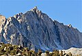
 North aspect, from Long Lake | |
| Highest point | |
| Elevation | 13,085 ft (3,988 m) [1] |
| Prominence | 845 ft (258 m) [1] |
| Parent peak | Mount Gilbert [1] |
| Isolation | 1.62 mi (2.61 km) [1] |
| Listing | Sierra Peaks Section |
| Coordinates | 37°07′23″N118°34′05″W / 37.1230273°N 118.5681061°W [2] |
| Naming | |
| Etymology | Richard Urquhart Goode |
| Geography | |
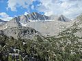
 Mount Goode  Mount Goode | |
| Location | Fresno and Inyo counties California, U.S. |
| Parent range | Sierra Nevada [1] |
| Topo map | USGS North Palisade |
| Geology | |
| Rock type | granite |
| Climbing | |
| First ascent | July 16, 1939 by Chester Versteeg [3] |
| Easiest route | class 2 [3] |
Mount Goode is a 13,085-foot-elevation (3,988-meter) mountain summit located on the crest of the Sierra Nevada mountain range in California, United States. [2] It is situated on the shared boundary of Kings Canyon National Park with the John Muir Wilderness, and along the common border of Fresno County with Inyo County. It is also approximately one mile west-northwest of Bishop Pass, one mile east-southeast of Mount Johnson, 1.23 miles (1.98 km) south of Hurd Peak, and 16 miles (26 km) west of the community of Big Pine.